EN Glaciers at the time of the Kleinmeister

Ice giants up close - glaciers at the time of the Kleinmeister
Bilder
nb-742845
Titel
View of the snow-capped mountains from the Central Plateau, 1802
Text

The view from the northern shore of Lake Biel near Ligerz opens up a wide vista of peaks covered in perpetual ice. The Schreckhorn, Finsteraarhorn, Wetterhorn, Eiger, Mönch and Jungfrau are clearly visible from left to right. Many of the glaciers that we will visit below are located in these Bernese Alps.

In 1810, Johann Gottfried Ebel (1764-1830) estimated the extent of the glaciers in the central Alps as follows:

"In the Alps from Mont Blanc to the border of Tyrol there are about 400 glaciers, of which very few are less than an hour [equivalent to about 4.5 km] long, very many are 6-7 hours long and 1/2-4 hours wide and 100-600 f[uss] [1 foot corresponds to approx. 30 cm] thick. It is impossible to determine the exact surface extent of all these ice masses; however, the mind can be given a total idea. I have tried to calculate the extent of all the glaciers according to a scale that is certainly too small rather than too large; and the result is that in the Alps from Mont Blanc through the whole of Switzerland to the border of Tyrol there is a sea of ice of almost 50 German square miles [1 mile corresponds to about 7.5 km], which is the inexhaustible source of the most important and largest rivers in Europe."

Ort auf moderner Karte
GEOMETRYCOLLECTION (POINT (7.136929 47.086375), LINESTRING (7.136929 47.086375, 7.137423 47.084939))
Camera Settings (3D)
{"landscape":{"camera.fov":60,"image.scale":350,"viewpoint":{"bounds":[[6.098079031824454,47.08227167562444],[7.5778328152908045,47.970027513119334]],"bearing":145.00838023530946,"pitch":81.68282539727909,"zoom":14.315392963997366,"center":{"lng":7.154136851454155,"lat":47.06961621366531},"cam":{"center":{"lng":7.166927574450881,"lat":47.5527032347899},"zoom":9.26574292747678,"bearing":0},"cameraToCenterDistance":1107.646491440297,"cameraPosition":{"lngLat":{"lng":7.1324608231323054,"lat":47.090703416033136},"altitude":847.0046106198213},"cameraTargetElevation":428.5}},"portrait":{"image.scale":200,"viewpoint":{"bounds":[[6.755956661618285,46.31447215546862],[8.030232574068322,47.08992349511965]],"bearing":144.93763193569293,"pitch":76.2205651243721,"zoom":15.094402505473322,"center":{"lng":7.144449949264526,"lat":47.078765824340365},"cameraToCenterDistance":1107.646491440297,"cameraPosition":{"lngLat":{"lng":7.1320291654384675,"lat":47.09081644854223},"altitude":830.0205258252629},"cameraTargetElevation":428.5}},"square":{"viewpoint":{"bounds":[[1.7223274469135106,39.80116191233529],[15.229307994699724,47.08895356782418]],"bearing":154.60838023529095,"pitch":78.85386346506654,"zoom":15.08646978872041,"center":{"lng":7.143251670092354,"lat":47.077132356413586},"cam":{"center":{"lng":69.25723018584463,"lat":48.25057167304297},"zoom":1.7362198016567238,"bearing":0},"cameraToCenterDistance":1107.646491440297,"cameraPosition":{"lngLat":{"lng":7.1338340450260205,"lat":47.090642599531066},"altitude":756.1829577001613},"cameraTargetElevation":428.5},"image.scale":200}}
Quellen

Johann Gottfried Ebel, Anleitung auf die nützlichste und genussvollste Art in der Schweitz zu reisen, vol. 3, Zurich 1810, p. 121

Bilder
nb-480787
Titel
The glaciers in Grindelwald around 1790
Text

"This valley is one of the most famous and most visited in Switzerland, because nowhere else can you see and admire glaciers as safely and comfortably as here."

This sentence by Johann Gottfried Ebel (1764-1830) sums up what brought masses of tourists to Grindelwald around 1800. The Upper and Lower Grindelwald Glacier both ended in the immediate vicinity of the village settlements. The Lower Grindelwald Glacier was the only glacier in the Alps to reach below 1000 meters in altitude. At the time of this view, in the late 1780s, the Lower Grindelwald Glacier was retreating again after a strong advance. Carl Gottlob Küttner (1755-1805) describes the landscape, which is characterized by contrasts:

"The Wetterhorn, the Eiger and the Mettenberg separate this valley from the Republic of Valais. I have never seen a more strange contrast! No shrub grows on these three mountains, much less a tree; their upper part is covered with snow and ice, the latter of which descends into the valley in two places and forms the two glaciers that have so often been drawn and engraved. Strawberries, bilberries, blackberries and cranberries grow next to them, and the meadows are as beautiful as you will ever find in Switzerland."

Ort auf moderner Karte
GEOMETRYCOLLECTION (POINT (8.045672 46.626952), LINESTRING (8.045672 46.626952, 8.045812 46.626791))
Camera Settings (3D)
{"landscape":{"camera.fov":60,"image.scale":350,"viewpoint":{"bounds":[[7.572312178606239,43.827940427355685],[11.153600128006161,46.63442978439505]],"bearing":133.00838023543167,"pitch":78.41074172493299,"zoom":15.15974061598488,"center":{"lng":8.051766157151405,"lat":46.6245075301222},"cam":{"center":{"lng":10.892164466795606,"lat":45.368012650754935},"zoom":7.048993149302527,"bearing":0},"cameraToCenterDistance":1107.646491440297,"cameraPosition":{"lngLat":{"lng":8.036524934984698,"lat":46.6342704421501},"altitude":1371.164821985854},"cameraTargetElevation":1044.753125025432}},"portrait":{"image.scale":300,"viewpoint":{"bounds":[[7.572312175024905,43.8279404060946],[11.153600150988296,46.63442978439616]],"bearing":133.00838023543167,"pitch":78.41074172493299,"zoom":15.15974061598488,"center":{"lng":8.05176615715095,"lat":46.624507530123225},"cameraToCenterDistance":1107.646491440297,"cameraPosition":{"lngLat":{"lng":8.036524934984214,"lat":46.63427044215112},"altitude":1371.1648219858475},"cameraTargetElevation":1044.753125025432}},"square":{"viewpoint":{"bounds":[[7.5723121683540455,43.82794036353198],[11.15360019715635,46.63442978439605]],"bearing":133.00838023543167,"pitch":78.41074172493299,"zoom":15.15974061598488,"center":{"lng":8.051766157151292,"lat":46.624507530123395},"cam":{"center":{"lng":25.47875231236557,"lat":46.49520153390168},"zoom":3.6513745427608093,"bearing":0},"cameraToCenterDistance":1107.646491440297,"cameraPosition":{"lngLat":{"lng":8.036524934984556,"lat":46.634270442151234},"altitude":1371.1648219858466},"cameraTargetElevation":1044.753125025432},"image.scale":442}}
Quellen

Johann Gottfried Ebel, Anleitung, auf die nützlichste und genussvollste Art die Schweitz bereisen, vol. 3, Zurich, p. 171; Carl Gottlob Küttner, Briefe eines Sachsen aus der Schweiz an einen Freund in Leipzig, Leipzig 1785/86, vol. 2, p. 141; GLAMOS 1881-2023, The Swiss Glaciers 1880-2022/23, Glaciological Reports No 1-142, Yearbooks of the Cryospheric Commission of the Swiss Academy of Sciences (SCNAT), published since 1964 by VAW / ETH Zurich, doi:10.18752/glrep_series; Heinz Jürg Zumbühl (ed.), Die Kleine Eiszeit. Gletschergeschichte im Spiegel der Kunst (exhib. cat. Lucerne/Bern 1983), Bern 1984, Fig. 1

Bilder
nb-476971
Titel
Lower Grindelwald Glacier, 1768
Text

When Johann Ludwig Aberli drew this view around 1768, the Lower Grindelwald Glacier was less impressive than it would be fifty years later. It ended at the exit of the glacier gorge on the Schopffelsen and could not be seen very well from the valley. Nevertheless, tourists visited the place where the Lütschine gushed out of the glacier gorge.

Ort auf moderner Karte
GEOMETRYCOLLECTION (POINT (8.046475 46.613699), LINESTRING (8.046475 46.613699, 8.047048 46.61299))
Camera Settings (3D)
{"landscape":{"camera.fov":60,"viewpoint":{"bounds":[[8.011588838472903,46.61507829780075],[8.06390064191703,46.64438043776107]],"bearing":151.0009254301233,"pitch":85,"zoom":17.369540447510182,"center":{"lng":8.04720103740533,"lat":46.61292514342432},"cam":{"center":{"lng":8.054747916155861,"lat":46.63102869711247},"zoom":13.539830040299789,"bearing":0},"cameraToCenterDistance":1131.8952027462615,"cameraPosition":{"lngLat":{"lng":8.044931230705487,"lat":46.615738019487594},"altitude":1108.7467628849797},"cameraTargetElevation":1077.4588867187506},"image.scale":135},"portrait":{"image.scale":130,"viewpoint":{"bounds":[[8.011588838480804,46.615078297800125],[8.0639006418929,46.64438043774294]],"bearing":151.0009254301233,"pitch":85,"zoom":17.369540447510182,"center":{"lng":8.047201037404989,"lat":46.612925143423695},"cameraToCenterDistance":1131.8952027462615,"cameraPosition":{"lngLat":{"lng":8.044931230705089,"lat":46.61573801948694},"altitude":1108.7467628849802},"cameraTargetElevation":1077.4588867187506}},"square":{"image.scale":135,"viewpoint":{"bounds":[[8.011588838455197,46.61507829779933],[8.063900641921919,46.644380437775965]],"bearing":151.0009254301233,"pitch":85,"zoom":17.369540447510182,"center":{"lng":8.047201037407376,"lat":46.6129251434229},"cam":{"center":{"lng":8.163293068508608,"lat":46.63930998540795},"zoom":10.655463373451456,"bearing":0},"cameraToCenterDistance":1131.8952027462615,"cameraPosition":{"lngLat":{"lng":8.044931230707476,"lat":46.615738019486145},"altitude":1108.7467628849806},"cameraTargetElevation":1077.4588867187506}}}
Quellen

Heinz Jürg Zumbühl (ed.),  Die Kleine Eiszeit. Gletschergeschichte im Spiegel der Kunst (exhib. cat. Lucerne/Bern 1983), Bern 1984, fig. 1

Bilder
nb-482008
Titel
The Lower Grindelwald Glacier around 1775
Text

"Access to the Lower Grindelwald Glacier, which lets out the waters of the Lütschinen, is not difficult.
Even ladies can walk effortlessly to its tongue in the valley and get a real idea of this unique sight."

By 1775, the glacier had grown again, so that the end of its tongue protruded slightly from the glacier gorge. At this point, it formed the "tail" that was to be depicted again and again in the 19th century. By 1790, however, this lowest part of the glacier had retreated back to the Schopffelsen. Gottlieb Sigmund Gruner (1717-1778 ) wrote in 1778:

"The people of Grindelwald complain: the glaciers are taking more and more fertile land away from them. I heard the same complaint on the Grimsel, about two ice valleys that were once fertile but are now glaciated. In the Valais, in Faucigny, in all places it is the same. So it must be the same. Here in Grindelwald there is convincing proof of this in the larch trees, which now stand a whole hour deep in the ice [an hour being a distance of about 4.5 km] [...]. So it seems undeniable that the glaciers are gradually conquering more land."

Ort auf moderner Karte
GEOMETRYCOLLECTION (POINT (8.045511 46.613364), LINESTRING (8.045511 46.613364, 8.045962 46.613297))
Camera Settings (3D)
{"landscape":{"camera.fov":60,"viewpoint":{"bounds":[[8.029590742673832,46.609064275425936],[8.044583580221598,46.6271926410524]],"bearing":105.75641222948366,"pitch":85,"zoom":18.436742513024118,"center":{"lng":8.046341389431518,"lat":46.61334430431785},"cam":{"center":{"lng":8.047212021987974,"lat":46.618901915519075},"zoom":14.287732251079733,"bearing":0},"cameraToCenterDistance":1107.646491440297,"cameraPosition":{"lngLat":{"lng":8.044236970246914,"lat":46.61375216864462},"altitude":1035.5460273253634},"cameraTargetElevation":1020.934088460802}},"portrait":{"image.scale":50,"viewpoint":{"bounds":[[8.027226025553034,46.60843611552289],[8.044106156768834,46.6288462808827]],"bearing":105.75641222948366,"pitch":85,"zoom":18.26568984226843,"center":{"lng":8.046085238456726,"lat":46.61325494502046},"cameraToCenterDistance":1107.646491440297,"cameraPosition":{"lngLat":{"lng":8.043715915638302,"lat":46.613714151722064},"altitude":1035.5460389011903},"cameraTargetElevation":1019.0947265621526}},"square":{"viewpoint":{"bounds":[[8.02957630406948,46.60905967903983],[8.044583732633697,46.62720585388897]],"bearing":105.75641223156254,"pitch":84.99734483639747,"zoom":18.436736662255356,"center":{"lng":8.04634138943618,"lat":46.61334430431634},"cam":{"center":{"lng":8.10461344689071,"lat":46.62328726393494},"zoom":11.550032485389096,"bearing":0},"cameraToCenterDistance":1107.646491440297,"cameraPosition":{"lngLat":{"lng":8.044236970251575,"lat":46.61375216864309},"altitude":1033.7144644109528},"cameraTargetElevation":1019.0947265621526}}}
Quellen

Jakob Samuel Wyttenbach, Vues remarquables des montagnes de la Suisse, dessinées et colorées d'après nature, Amsterdam 1785, Introduction; Heinz Jürg Zumbühl (ed.), Die Kleine Eiszeit. Gletschergeschichte im Spiegel der Kunst (exhib. cat. Lucerne/Bern 1983), Bern 1984, fig. 1; Gottlieb Sigmund Gruner, Reisen durch die merkwürdigsten Gegenden Helvetiens, Londen [i. e. Bern] 1778, vol. 2, pp. 23-24
 

Bilder
SFF_D_1392
Titel
Lower Grindelwald Glacier, 1822
Text

The first major advance of the Lower Grindelwald Glacier in the 19th century began around 1812/14. It reached its greatest extent around 1820. In the previous six to eight years, it had grown 450 to 520 m longer and now formed the so-called "tail", which reached almost to the valley floor.

Ort auf moderner Karte
GEOMETRYCOLLECTION (POINT (8.042464 46.62277), LINESTRING (8.042464 46.62277, 8.042518 46.62257))
Camera Settings (3D)
{"landscape":{"viewpoint":{"bounds":[[7.928682063216314,46.62341405072294],[8.162426552447641,46.719156152009276]],"bearing":167.47875273679657,"pitch":84.98934666732012,"zoom":15.316234264494216,"center":{"lng":8.045859932901067,"lat":46.61287908156612},"cam":{"center":{"lng":8.09907974883535,"lat":46.675387062536004},"zoom":11.885409510326436,"bearing":0},"cameraToCenterDistance":1107.646491440297,"cameraPosition":{"lngLat":{"lng":8.041737178105848,"lat":46.6256296157392},"altitude":1155.8077778890179},"cameraTargetElevation":1028.4574224645455},"image.scale":145},"portrait":{"image.scale":150,"viewpoint":{"bounds":[[7.929126969907259,46.62341796266193],[8.161952400912156,46.718787540800236]],"bearing":167.47875273673074,"pitch":85,"zoom":15.316257758326604,"center":{"lng":8.04585993289993,"lat":46.612879081567826},"cameraToCenterDistance":1107.646491440297,"cameraPosition":{"lngLat":{"lng":8.041737178104654,"lat":46.62562961574096},"altitude":1155.5356325494784},"cameraTargetElevation":1028.4574223890666}},"square":{"image.scale":150,"viewpoint":{"bounds":[[7.929126969915075,46.62341796266048],[8.16195240092199,46.71878754079762]],"bearing":167.47875273673074,"pitch":85,"zoom":15.316257758326604,"center":{"lng":8.045859932901521,"lat":46.61287908156632},"cam":{"center":{"lng":9.093254124949624,"lat":46.75094542503504},"zoom":7.59453254197536,"bearing":0},"cameraToCenterDistance":1107.646491440297,"cameraPosition":{"lngLat":{"lng":8.041737178106189,"lat":46.62562961573943},"altitude":1155.5356325494818},"cameraTargetElevation":1028.4574223890666}}}
Quellen

Heinz Jürg Zumbühl (ed.), Die Kleine Eiszeit. Gletschergeschichte im Spiegel der Kunst (exhib. cat. Lucerne/Bern 1983), Bern 1984, p. 11

Bilder
nb-477293
Titel
Lower Grindelwald Glacier, 1837
Text

The glacier more or less maintained its 1820 level for around 20 years. The second advance of the 19th century began in 1840 and lasted until 1860. Since then, the ice mass has retreated around 4.5 km, particularly rapidly in the last 20 years.

This gouache by Johann Ludwig Bleuler shows the glacier at dawn. The source at the Ischmeer is already illuminated by the sun, while the tail, which reaches down to the valley floor, is still in the shadow of the Mättenberg. Bleuler skillfully contrasts the orderly village view in the foreground with the impetuous ice masses of the Lower Grindelwald Glacier.


Ort auf moderner Karte
GEOMETRYCOLLECTION (POINT (8.044342 46.630644), LINESTRING (8.044342 46.630644, 8.044333 46.630422))
Camera Settings (3D)
{"landscape":{"camera.fov":60,"viewpoint":{"bounds":[[7.897536120264448,46.630449832762196],[8.398632794124751,46.81271247501695]],"bearing":-168.63232909139845,"pitch":80.72195416584539,"zoom":16.963498465325923,"center":{"lng":8.043665885926885,"lat":46.62741056809526},"cam":{"center":{"lng":8.255622342494036,"lat":46.729848816354206},"zoom":10.878861185824395,"bearing":0},"cameraToCenterDistance":1107.646491440297,"cameraPosition":{"lngLat":{"lng":8.044851350516893,"lat":46.63145972207491},"altitude":1197.4155844241832},"cameraTargetElevation":1122.3875000000019}},"portrait":{"viewpoint":{"bounds":[[7.899862130815336,46.6304967901271],[8.392302008781911,46.80961578834135]],"bearing":-168.63232909139845,"pitch":80.72195416584539,"zoom":16.988639823278078,"center":{"lng":8.043467402458191,"lat":46.62751003491056},"cameraToCenterDistance":1107.646491440297,"cameraPosition":{"lngLat":{"lng":8.044632387323077,"lat":46.63148923219879},"altitude":1197.4155756723299},"cameraTargetElevation":1123.6837890625611},"image.scale":40},"square":{"viewpoint":{"bounds":[[7.899862130843218,46.63049679012704],[8.39230200862906,46.809615788301755]],"bearing":-168.63232909139845,"pitch":80.72195416584539,"zoom":16.988639823278078,"center":{"lng":8.043467402459328,"lat":46.62751003491064},"cam":{"center":{"lng":10.36206151977234,"lat":46.88866578850511},"zoom":6.513833595206326,"bearing":0},"cameraToCenterDistance":1107.646491440297,"cameraPosition":{"lngLat":{"lng":8.044632387324214,"lat":46.631489232198874},"altitude":1197.4155756723299},"cameraTargetElevation":1123.6837890625611},"image.scale":40,"camera.fov":60}}
Quellen

Heinz Jürg Zumbühl (ed.), Die Kleine Eiszeit. Gletschergeschichte im Spiegel der Kunst (exhib. cat. Lucerne/Bern 1983), Bern 1984, Fig. 1; GLAMOS 1881-2023, The Swiss Glaciers 1880-2022/23, Glaciological Reports No 1-142, Yearbooks of the Cryospheric Commission of the Swiss Academy of Sciences (SCNAT), published since 1964 by VAW / ETH Zurich, doi:10.18752/glrep_series.

Bilder
zbz-990054269390205508
Titel
The Lower Grindelwald Glacier with the Hotel Bär, 1897
Text

It was not least the glaciers that led to the strong growth of tourism in Grindelwald. The Grandhotel Bär was one of several large hotels to open in 1893 after the old hotel was destroyed in the great village fire of 1892. In 1941, it again fell victim to a fire and was not rebuilt.
By 1900, the Lower Grindelwald Glacier had already retreated as far as it probably had around 1570. It is still visible from the opposite side of the valley, but its former extent can only be recognized by the apery slopes and rock faces, which are only slowly being recolonized by vegetation.

Ort auf moderner Karte
GEOMETRYCOLLECTION (POINT (8.033656 46.625083), LINESTRING (8.033656 46.625083, 8.03372 46.624928))
Camera Settings (3D)
{"landscape":{"camera.fov":60,"viewpoint":{"bounds":[[7.410149402228882,45.96175972189428],[8.812655064073454,46.62602491727753]],"bearing":159.27089572011903,"pitch":78.51598441832205,"zoom":17.194283497096542,"center":{"lng":8.034688532350401,"lat":46.6232456916037},"cam":{"center":{"lng":8.480204660422402,"lat":46.32320581835208},"zoom":9.100858041771028,"bearing":0},"cameraToCenterDistance":1107.646491440297,"cameraPosition":{"lngLat":{"lng":8.032887183401925,"lat":46.626514601074916},"altitude":1106.5522238458811},"cameraTargetElevation":1027.5918457155806},"image.scale":70},"portrait":{"viewpoint":{"bounds":[[7.410149405655858,45.96175972522167],[8.812655060216713,46.626024917277675]],"bearing":159.27089572011903,"pitch":78.51598441832205,"zoom":17.194283497096542,"center":{"lng":8.034688532349719,"lat":46.62324569160393},"cameraToCenterDistance":1107.646491440297,"cameraPosition":{"lngLat":{"lng":8.032887183401243,"lat":46.62651460107509},"altitude":1106.552223845881},"cameraTargetElevation":1027.5918457155806},"image.scale":70},"square":{"viewpoint":{"bounds":[[7.410149402283679,45.961759721896556],[8.812655064096987,46.62602491727745]],"bearing":159.27089572011903,"pitch":78.51598441832205,"zoom":17.194283497096542,"center":{"lng":8.034688532349833,"lat":46.62324569160353},"cam":{"center":{"lng":14.422677711350104,"lat":46.77728496431703},"zoom":5.003846501428964,"bearing":0},"cameraToCenterDistance":1107.646491440297,"cameraPosition":{"lngLat":{"lng":8.032887183401328,"lat":46.626514601074774},"altitude":1106.5522238458816},"cameraTargetElevation":1027.5918457155806},"image.scale":70}}
Quellen

https://www.grindelwaldgeschichten.ch/zeitlupe/brand-grandhotel-baer [04.11.2024]; Heinz Jürg Zumbühl (ed.), Die Kleine Eiszeit. Gletschergeschichte im Spiegel der Kunst (exhib. cat. Lucerne/Bern 1983), Bern 1984, fig. 1

Bilder
nb-819199
Titel
Upper Grindelwald Glacier at the beginning of the 19th century
Text

"An hour's walk up the valley from Grindelwald, on the path to the Scheideck, a short distance to the right, lies the upper Grindelwald glacier. It differs little from the lower one and is no more beautiful, but at times has larger ice vaults on its lower edge, especially on the eastern side."

The Upper Grindelwald Glacier was further away from the village and therefore less of a tourist attraction. It also did not advance as spectacularly. Instead, the thickness of the ice changed, reaching the valley floor at all times. Nevertheless, it also grew in the first half of the 19th century.


Ort auf moderner Karte
GEOMETRYCOLLECTION (POINT (8.078009 46.631397), LINESTRING (8.078009 46.631397, 8.078771 46.630916))
Camera Settings (3D)
{"landscape":{"camera.fov":60,"image.scale":201,"viewpoint":{"bounds":[[8.016368830462653,46.63268805689145],[8.08112733984592,46.68462498650368]],"bearing":131.5505699902492,"pitch":85,"zoom":16.604784628747176,"center":{"lng":8.079714775105117,"lat":46.630372390527214},"cam":{"center":{"lng":8.0777770801607,"lat":46.660876473889516},"zoom":12.768139661306627,"bearing":0},"cameraToCenterDistance":1107.646491440297,"cameraPosition":{"lngLat":{"lng":8.073888963847622,"lat":46.63391800402019},"altitude":1336.905051130483},"cameraTargetElevation":1284.8999999999996}},"portrait":{"image.scale":160,"viewpoint":{"bounds":[[8.016368830484396,46.63268805689424],[8.081127339825116,46.68462498647156]],"bearing":131.5505699902492,"pitch":85,"zoom":16.604784628747176,"center":{"lng":8.079714775099205,"lat":46.630372390529885},"cameraToCenterDistance":1107.646491440297,"cameraPosition":{"lngLat":{"lng":8.073888963841625,"lat":46.633918004022775},"altitude":1336.9050511304802},"cameraTargetElevation":1284.8999999999996},"camera.fov":60},"square":{"image.scale":163,"viewpoint":{"bounds":[[8.01636883046669,46.63268805689728],[8.081127339842368,46.6846249865022]],"bearing":131.5505699902492,"pitch":85,"zoom":16.604784628747176,"center":{"lng":8.07971477509625,"lat":46.63037239053287},"cam":{"center":{"lng":8.340161377345197,"lat":46.68088147336499},"zoom":9.440639508324052,"bearing":0},"cameraToCenterDistance":1107.646491440297,"cameraPosition":{"lngLat":{"lng":8.073888963838698,"lat":46.633918004025816},"altitude":1336.9050511304774},"cameraTargetElevation":1284.8999999999996},"camera.fov":60}}
Quellen

Karl Baedeker, Die Schweiz. Handbüchlein für Reisende, nach eigener Anschauung und den besten Hülfsquellen bearbeitet, Koblenz 1844, p. 167; Heinz Jürg Zumbühl (ed.), Die Kleine Eiszeit. Gletschergeschichte im Spiegel der Kunst (exhib. cat. Lucerne/Bern 1983), Bern 1984, p. 12

Bilder
SFF_D_1210
Titel
Upper Grindelwald glacier around 1835
Text

The church in Grindelwald with the mighty Wetterhorn towering behind it is still a popular photo subject today. Unlike today, however, the Upper Grindelwald Glacier was also an unmissable feature of the landscape and was visited for its spectacular location.

"Though the Lower Glacier exhibits inequalities in the shape of towers, obelisks, columns, &c.,  more diversified and more clearly defined than the Upper Glacier, yet the traveler would do well to visit the latter, were it only for the purpose of enjoying a nearer view of the Wetterhorn. This mountain is thus named from the storms of which its summit, almost always shrouded, is the focus, in the opinion of the inhabitants, whom it serves for a barometer."


Ort auf moderner Karte
GEOMETRYCOLLECTION (POINT (8.042679 46.624243), LINESTRING (8.042679 46.624243, 8.043054 46.624294))
Camera Settings (3D)
{"landscape":{"camera.fov":60,"image.scale":59,"viewpoint":{"bounds":[[8.016496101421751,46.609858304170444],[8.041863424631316,46.641791195283076]],"bearing":81.99641042532835,"pitch":85,"zoom":17.660875587246238,"center":{"lng":8.044985532765054,"lat":46.62450200388747},"cam":{"center":{"lng":8.047017115225628,"lat":46.62718819599198},"zoom":13.47073281201465,"bearing":0},"cameraToCenterDistance":1107.646491440297,"cameraPosition":{"lngLat":{"lng":8.041278097375738,"lat":46.62414399771873},"altitude":1075.3794015625247},"cameraTargetElevation":1050.3657226803562}},"portrait":{"image.scale":36,"viewpoint":{"bounds":[[8.016496101405664,46.60985830416277],[8.041863424629526,46.641791195296776]],"bearing":81.99641042532835,"pitch":85,"zoom":17.660875587246238,"center":{"lng":8.044985532763349,"lat":46.624502003887386},"cameraToCenterDistance":1107.646491440297,"cameraPosition":{"lngLat":{"lng":8.041278097374004,"lat":46.62414399771859},"altitude":1075.3794015625247},"cameraTargetElevation":1050.3657226803562}},"square":{"viewpoint":{"bounds":[[8.01649610140862,46.60985830417292],[8.04186342462711,46.6417911952874]],"bearing":81.99641042532835,"pitch":85,"zoom":17.660875587246238,"center":{"lng":8.044985532760847,"lat":46.624502003887045},"cam":{"center":{"lng":8.143332717501096,"lat":46.634537034039624},"zoom":10.792737993078084,"bearing":0},"cameraToCenterDistance":1107.646491440297,"cameraPosition":{"lngLat":{"lng":8.041278097371503,"lat":46.624143997718335},"altitude":1075.379401562525},"cameraTargetElevation":1050.3657226803562}}}
Quellen

Picturesque Tour through the Oberland in the Canton of Berne, in Switzerland, London 1823, pp. 94-95

Bilder
zbz-990053319810205508
Titel
The Upper Grindelwald Glacier in October 1854
Text

On October 2, 1854, Georg Meyer-Zimmermann (1814-1895) depicted the Upper Grindelwald Glacier at the time of its greatest extent in this watercolor.

Ort auf moderner Karte
GEOMETRYCOLLECTION (POINT (8.072526 46.635137), LINESTRING (8.072526 46.635137, 8.072695 46.634911))
Camera Settings (3D)
{"landscape":{"image.scale":68,"viewpoint":{"bounds":[[7.986827253382444,46.63491363696923],[8.129473858707541,46.70925590259489]],"bearing":154.36670942659566,"pitch":85,"zoom":15.908318698701896,"center":{"lng":8.07769238948822,"lat":46.628843609391225},"cam":{"center":{"lng":8.099712844516034,"lat":46.675266227038776},"zoom":12.250359194542327,"bearing":0},"cameraToCenterDistance":1107.646491440297,"cameraPosition":{"lngLat":{"lng":8.072234898168233,"lat":46.63665361138382},"altitude":1319.7333134452467},"cameraTargetElevation":1235.4551757812496}},"portrait":{"camera.fov":60,"viewpoint":{"bounds":[[7.987331056092756,46.6347628554887],[8.128251974992793,46.708206571361785]],"bearing":154.36670942659566,"pitch":85,"zoom":15.925878323193293,"center":{"lng":8.077096939086914,"lat":46.62876624823343},"cameraToCenterDistance":1107.646491440297,"cameraPosition":{"lngLat":{"lng":8.071705470489945,"lat":46.63648178545682},"altitude":1319.7336907421964},"cameraTargetElevation":1236.4749999996043}},"square":{"viewpoint":{"bounds":[[7.987331056101112,46.63476285548694],[8.128251974993589,46.70820657135559]],"bearing":154.36670942659566,"pitch":85,"zoom":15.925878323193293,"center":{"lng":8.07709693908896,"lat":46.628766248231614},"cam":{"center":{"lng":8.691935650563607,"lat":46.719824143817135},"zoom":8.318895403967126,"bearing":0},"cameraToCenterDistance":1107.646491440297,"cameraPosition":{"lngLat":{"lng":8.071705470491992,"lat":46.636481785455004},"altitude":1319.733690742199},"cameraTargetElevation":1236.4749999996043}}}
Quellen

Heinz Jürg Zumbühl (ed.), Die Kleine Eiszeit. Gletschergeschichte im Spiegel der Kunst (exhib. cat. Lucerne/Bern 1983), Bern 1984, p. 12

Bilder
zbz-990054266860205508
Titel
Wetterhorn elevator with the Eiger between 1905 and 1914
Text

The Upper Grindelwald Glacier also melts more slowly than its lower neighbor. At the beginning of the 20th century, it still offered this spectacular sight when you floated over it in the Wetterhorn elevator.

This elevator opened in 1907 and was the first electric cable car for passenger transport in Switzerland. It was actually intended to run to the summit of the Wetterhorn, but only the first stage was built. When the First World War broke out in 1914 and tourists stopped coming, the project was abandoned. Until then, tourists could prove they had a head for heights for five francs (around 55 francs today).


Ort auf moderner Karte
GEOMETRYCOLLECTION (POINT (8.0792 46.633273), POINT (8.0792 46.633273), LINESTRING (8.0792 46.633273, 8.079087 46.633068))
Camera Settings (3D)
{"landscape":{"image.scale":68,"viewpoint":{"bounds":[[7.935267906320945,46.63263042229315],[8.85332615591048,47.039164038857905]],"bearing":-153.2731616979865,"pitch":80.48842142673068,"zoom":16.215099497829932,"center":{"lng":8.075444698334877,"lat":46.62839417635769},"cam":{"center":{"lng":8.622269884257861,"lat":46.8536069814204},"zoom":9.794844153220817,"bearing":0},"cameraToCenterDistance":1107.646491440297,"cameraPosition":{"lngLat":{"lng":8.079985676412747,"lat":46.63458686933839},"altitude":1399.9862143670002},"cameraTargetElevation":1270.803125},"camera.fov":60},"portrait":{"camera.fov":60,"viewpoint":{"bounds":[[7.937330070455033,46.63259986561451],[8.842123742058646,47.033290243234944]],"bearing":-153.27316169760155,"pitch":80.49999999999999,"zoom":16.22239094996074,"center":{"lng":8.075444698335446,"lat":46.628383124677896},"cameraToCenterDistance":1107.646491440297,"cameraPosition":{"lngLat":{"lng":8.0799629368708,"lat":46.63454480996063},"altitude":1399.8268387558269},"cameraTargetElevation":1271.4499999983937}},"square":{"camera.fov":60,"image.scale":50,"viewpoint":{"bounds":[[7.937330070051161,46.63259986561383],[8.842123744256611,47.03329024438261]],"bearing":-153.27316169760155,"pitch":80.49999999999999,"zoom":16.22239094996074,"center":{"lng":8.075444698335673,"lat":46.628383124677214},"cam":{"center":{"lng":12.461298441078469,"lat":47.1419226401064},"zoom":5.636192348344118,"bearing":0},"cameraToCenterDistance":1107.646491440297,"cameraPosition":{"lngLat":{"lng":8.07996293687097,"lat":46.63454480995995},"altitude":1399.8268387558285},"cameraTargetElevation":1271.4499999983937}}}
Bilder
nb-477160
Titel
Rosenlaui, 1800
Text

During the entire Little Ice Age, the Rosenlaui Glacier ended about 650 meters before its current level. Around 1820, it advanced even further and almost reached the bottom of the valley. However, this view shows the end of the glacier before this advance.

"[The Rosenlaui Glacier] is smaller than the Grindelwald glaciers, but is famous above all others for the crystalline purity of its ice and the translucent azure in the crevasses and fissures. This characteristic is undoubtedly due to the types of mountains that enclose it, which do not deposit marl shale or other impurities in their deposits, giving the Grindelwald Glacier such a dirty appearance. On the left side of the glacier, a steep path leads in half an hour to a rocky reef overlooking the glacier, from where you have a good view of the glacier. The outer contours of the reef have the shape of a human face, which is why it is also known as the guardian of the glacier. There's also a guy here who, on the arrival of every traveler, is extremely active, chopping steps into the ice with an axe and expecting a tip in return."


Ort auf moderner Karte
GEOMETRYCOLLECTION (POINT (8.159237 46.675655), LINESTRING (8.159237 46.675655, 8.159419 46.675508))
Camera Settings (3D)
{"landscape":{"viewpoint":{"bounds":[[8.102493463570653,46.678105004951135],[8.220059042990044,46.72501636680954]],"bearing":168.79354637623146,"pitch":85,"zoom":16.308995753755998,"center":{"lng":8.159955739974976,"lat":46.67275951848151},"cam":{"center":{"lng":8.187517147075084,"lat":46.70356529559595},"zoom":12.913817426917266,"bearing":0},"cameraToCenterDistance":1107.646491440297,"cameraPosition":{"lngLat":{"lng":8.158098559798816,"lat":46.679191173636696},"altitude":1660.5875389920752},"cameraTargetElevation":1596.7984375007163},"image.scale":230},"portrait":{"viewpoint":{"bounds":[[8.091576533886524,46.67836405867689],[8.241592376929475,46.734489712540324]],"bearing":171.99354637623142,"pitch":85,"zoom":15.970987891084404,"center":{"lng":8.16036343574524,"lat":46.6714527931027},"cameraToCenterDistance":1107.646491440297,"cameraPosition":{"lngLat":{"lng":8.15868101445625,"lat":46.67965976707967},"altitude":1731.5218546321137},"cameraTargetElevation":1650.8898437507821},"image.scale":200,"camera.fov":60},"square":{"viewpoint":{"bounds":[[8.10249346347365,46.67810500495156],[8.220059043071473,46.7250163668576]],"bearing":168.79354637623146,"pitch":85,"zoom":16.308995753755998,"center":{"lng":8.159955739973611,"lat":46.672759518481996},"cam":{"center":{"lng":8.690321361462935,"lat":46.741863877887795},"zoom":8.580315455975754,"bearing":0},"cameraToCenterDistance":1107.646491440297,"cameraPosition":{"lngLat":{"lng":8.158098559797423,"lat":46.67919117363721},"altitude":1660.5875389920748},"cameraTargetElevation":1596.7984375007163},"image.scale":200},"null":{"image.scale":300,"viewpoint":{"bounds":[[8.098740396043922,46.678275474311334],[8.19991085040138,46.72946241152886]],"bearing":155.99354637632246,"pitch":85,"zoom":16.422922620039714,"center":{"lng":8.16135048865101,"lat":46.67393738470645},"cam":{"center":{"lng":8.17103731536497,"lat":46.70552934072518},"zoom":13.187162118012488,"bearing":0},"cameraToCenterDistance":1107.646491440297,"cameraPosition":{"lngLat":{"lng":8.157757889433611,"lat":46.67947203773409},"altitude":1692.0261078217836},"cameraTargetElevation":1633.0818348496553}}}
Quellen

Heinz Jürg Zumbühl (ed.), Die Kleine Eiszeit. Gletschergeschichte im Spiegel der Kunst (Exhib.Cat. Lucerne/Bern 1983), Bern 1984, pp. 10-12; GLAMOS 1881-2023, The Swiss Glaciers 1880-2022/23, Glaciological Reports No 1-142, Yearbooks of the Cryospheric Commission of the Swiss Academy of Sciences (SCNAT), published since 1964 by VAW / ETH Zurich, doi:10.18752/glrep_series; Karl Baedeker, Die Schweiz. Handbüchlein für Reisende, nach eigener Anschauung und des besten Hülfsquellen bearbeitet, Koblenz 1844, pp. 169-170

Bilder
nb-479958
Titel
Rosenlaui, 1822
Text

During the advance, the glacier almost reaches the bottom of the valley around 1825.

"Halfway to Meyringen, we stop to take a last look at the great mountains of Grindelwald, which will soon no longer be visible: The mighty Jungfrau has already disappeared; the Eiger, which touches it, still shows its sharp peak at the end of the gorge; closer to us is the storm peak (the Wetter-Horn), which is almost permanently shrouded in cloud; the great bare rock of the Well-Horn stands in the middle, and behind it the radiant glaciers of the Rosenlaui spread out. This imposing image is characteristic: it captures the austere yet vibrant nature of the Swiss mountains. Many painters have stopped at this place and taken great impressions home with them."


Ort auf moderner Karte
GEOMETRYCOLLECTION (POINT (8.166318 46.691951), LINESTRING (8.166318 46.691951, 8.165417 46.691098))
Camera Settings (3D)
{"landscape":{"camera.fov":60,"viewpoint":{"bounds":[[8.163247411053817,46.691913668481504],[8.231672617538663,46.72555766390008]],"bearing":-145.80667968561517,"pitch":84.99018119781311,"zoom":16.12741823961994,"center":{"lng":8.161967396736145,"lat":46.68786002636341},"cam":{"center":{"lng":8.218997128468516,"lat":46.71037916896941},"zoom":13.198809336098194,"bearing":0},"cameraToCenterDistance":923.1830804342117,"cameraPosition":{"lngLat":{"lng":8.167043701330101,"lat":46.69298497826239},"altitude":1365.8979072685338},"cameraTargetElevation":1305.4999999999077},"image.scale":76},"portrait":{"viewpoint":{"bounds":[[8.091576533886524,46.67836405867689],[8.241592376929475,46.734489712540324]],"bearing":171.99354637623142,"pitch":85,"zoom":15.970987891084404,"center":{"lng":8.16036343574524,"lat":46.6714527931027},"cameraToCenterDistance":1107.646491440297,"cameraPosition":{"lngLat":{"lng":8.15868101445625,"lat":46.67965976707967},"altitude":1731.5218546321137},"cameraTargetElevation":1650.8898437507821},"image.scale":200,"camera.fov":60},"square":{"viewpoint":{"bounds":[[8.10249346347365,46.67810500495156],[8.220059043071473,46.7250163668576]],"bearing":168.79354637623146,"pitch":85,"zoom":16.308995753755998,"center":{"lng":8.159955739973611,"lat":46.672759518481996},"cam":{"center":{"lng":8.690321361462935,"lat":46.741863877887795},"zoom":8.580315455975754,"bearing":0},"cameraToCenterDistance":1107.646491440297,"cameraPosition":{"lngLat":{"lng":8.158098559797423,"lat":46.67919117363721},"altitude":1660.5875389920748},"cameraTargetElevation":1596.7984375007163},"image.scale":200},"null":{"image.scale":300,"viewpoint":{"bounds":[[8.098740396043922,46.678275474311334],[8.19991085040138,46.72946241152886]],"bearing":155.99354637632246,"pitch":85,"zoom":16.422922620039714,"center":{"lng":8.16135048865101,"lat":46.67393738470645},"cam":{"center":{"lng":8.17103731536497,"lat":46.70552934072518},"zoom":13.187162118012488,"bearing":0},"cameraToCenterDistance":1107.646491440297,"cameraPosition":{"lngLat":{"lng":8.157757889433611,"lat":46.67947203773409},"altitude":1692.0261078217836},"cameraTargetElevation":1633.0818348496553}}}
Quellen

Heinz Jürg Zumbühl (ed.), Die Kleine Eiszeit. Gletschergeschichte im Spiegel der Kunst (exhib. cat. Lucerne/Bern 1983), Bern 1984, pp. 10-12; Gabriel Lory fils (ed.), Voyage pittoresque de l'Oberland Bernois, Paris 1822, Vue des Montagnes du Wetter-Horn, Well-Horn, et du Glacier de Rosenlaui

Bilder
nb-482067
Titel
Lauteraar glacier around 1790
Text

The Aargletscher were also relatively easy to reach from the top of the Grimsel Pass. Johann Gottfried Ebel writes in his travel guide:

"Aargletscher. All the rocks around carry extensive glacier and ice valleys. The long Gelmer ice valley runs to the NE and the extraordinary Aar ice valleys lie to the SW. It is worth spending a day visiting the latter in good weather. Safe guides and signposts can be found in the Spithal; here you can enter the lap of high rock and glacier nature without danger, where everything bears the imprint of another world. From Spithal his to Zinken Stock 1 h, where the end of the Vorder or Lauteraar glacier ends in an ice wall. The glacier is covered with granite debris for 1 st.; the ascent is arduous, but takes no longer than 1/4 st. It is completely flat without crevasses, 6 st. long and 2 st. wide. Now and then round depressions, from the middle of which rise ice pillars carrying large blocks of rubble; ice pyramids 18 feet high made of transparent ice."

Ort auf moderner Karte
GEOMETRYCOLLECTION (POINT (8.191689 46.563668), LINESTRING (8.191689 46.563668, 8.184309 46.567799))
Camera Settings (3D)
{"landscape":{"camera.fov":60,"viewpoint":{"bounds":[[8.192386363106749,46.422097158653],[8.346809147758762,46.625618520788606]],"bearing":-79.88976785667705,"pitch":81.09004446577666,"zoom":17.377399391984635,"center":{"lng":8.188996016981037,"lat":46.56431365709415},"cam":{"center":{"lng":8.383069117986622,"lat":46.53262735478475},"zoom":10.801377950778187,"bearing":0},"cameraToCenterDistance":1107.646491440297,"cameraPosition":{"lngLat":{"lng":8.193444849248067,"lat":46.56376824443632},"altitude":2403.611712831962},"cameraTargetElevation":2349.4490722656255},"image.scale":43},"portrait":{"viewpoint":{"bounds":[[6.339566349296973,45.81524384091975],[8.193307385857679,48.24012269813656]],"bearing":-79.88976785667705,"pitch":78.71640848932248,"zoom":16.50865818436501,"center":{"lng":8.186616897583008,"lat":46.56453310761748},"cameraToCenterDistance":1107.646491440297,"cameraPosition":{"lngLat":{"lng":8.194681053758785,"lat":46.56354446773079},"altitude":2462.3038662846934},"cameraTargetElevation":2337.3562500000007},"image.scale":60},"square":{"viewpoint":{"bounds":[[6.339566462555894,45.81524388731154],[8.193307385854553,48.24012259726521]],"bearing":-79.88976785667705,"pitch":78.71640848932248,"zoom":16.50865818436501,"center":{"lng":8.186616897580166,"lat":46.5645331076166},"cam":{"center":{"lng":15.608271079049189,"lat":47.66935415597476},"zoom":4.60141346767894,"bearing":0},"cameraToCenterDistance":1107.646491440297,"cameraPosition":{"lngLat":{"lng":8.194681053755886,"lat":46.56354446772991},"altitude":2462.3038662846957},"cameraTargetElevation":2337.3562500000007},"image.scale":101}}
Quellen

Johann Gottfried Ebel, Anleitung, auf die nützlichste und genussvollste Art die Schweitz zu bereisen, vol. 3, Zurich 1810, pp. 165-166

Bilder
nb-482069
Titel
Stone table on the Unteraar glacier around 1790
Text

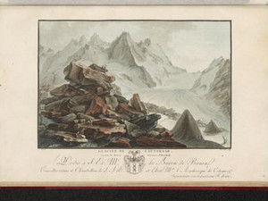
The Saxon traveler Carl Gottlob Küttner (1755-1805) visited the Aargletscher around 1780:

"Three hours further on, on the Lauteraar glacier, lies a large rock that, perhaps centuries ago, fell from the mountain peaks onto the ice. As the ice is constantly changing its shape, melting here, and taking on a fresh appearance there, the ice under this rock has gradually been consumed, so that it now rests on a column of ice, with most of it floating in the air. I know this strange play of nature and chance only from a drawing I have of it by Mr. Wolf, a Swiss painter, who has penetrated deeper into the icebergs than anyone before him. At Mr. Wagner's in Bern I saw a number of oil paintings by him, which are the fruit of these travels and which are to be engraved in copper and published with a description by a Bernese clergyman. It is astonishing how much effort these two men have gone to in order to penetrate the most remote ice valleys here, at Grindelwald, behind the Lauterbrunnen valley, etc., some of which have never been seen before."

Ort auf moderner Karte
GEOMETRYCOLLECTION (POINT (8.239403 46.567295), LINESTRING (8.239403 46.567295, 8.232536 46.566823))
Camera Settings (3D)
{"landscape":{"image.scale":120,"viewpoint":{"bounds":[[8.243737712636772,46.52988444762451],[8.28790299866293,46.59281436153259]],"bearing":-92.33142618268914,"pitch":85,"zoom":16.696815976354287,"center":{"lng":8.237452805043858,"lat":46.56727708626664},"cam":{"center":{"lng":8.30093050297944,"lat":46.564040789207354},"zoom":12.493746237461686,"bearing":0},"cameraToCenterDistance":1107.646491440297,"cameraPosition":{"lngLat":{"lng":8.244750334513384,"lat":46.56748134849255},"altitude":2087.9271311949997},"cameraTargetElevation":2039.0791015623747}},"portrait":{"image.scale":120,"viewpoint":{"bounds":[[8.243737712635266,46.529884447461086],[8.287902998844146,46.592814361634595]],"bearing":-92.33142618268914,"pitch":85,"zoom":16.696815976354287,"center":{"lng":8.237452805042267,"lat":46.56727708626681},"cameraToCenterDistance":1107.646491440297,"cameraPosition":{"lngLat":{"lng":8.24475033451182,"lat":46.56748134849272},"altitude":2087.9271311949997},"cameraTargetElevation":2039.0791015623747}},"square":{"image.scale":120,"viewpoint":{"bounds":[[8.243737712638904,46.52988444755056],[8.28790299874936,46.59281436158406]],"bearing":-92.33142618268914,"pitch":85,"zoom":16.696815976354287,"center":{"lng":8.237452805045905,"lat":46.567277086268035},"cam":{"center":{"lng":8.464564143191183,"lat":46.576539929628524},"zoom":9.99279642855041,"bearing":0},"cameraToCenterDistance":1107.646491440297,"cameraPosition":{"lngLat":{"lng":8.244750334515402,"lat":46.567481348493914},"altitude":2087.9271311949988},"cameraTargetElevation":2039.0791015623747}}}
Quellen

Carl Gottlob Küttner, Briefe eines Sachsen aus der Schweiz an einen Freund in Leipzig, Leipzig 1785/86, pp. 119-120

Bilder
nb-817138
Titel
Stone tables on the Unteraar glacier, 1822
Text

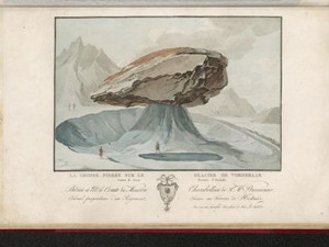
"[...] in the middle of this terrifying plain, these large stones, which look like bizarre monuments erected by mysterious beings, make the solitude even more gloomy and horrible."

Modern research describes the formation of these special formations as follows:

"[Glacier tables] sometimes reach considerable and spectacular heights, which depends not only on the size of the stone slab and the amount of ablation caused by the climate, but also on the position of the sun - this phenomenon does not occur at high latitudes. They are subject to a constant, periodic cycle of formation and destruction: from a certain height, depending on the angle of incidence of the sun, the one-sided melting of the base begins due to radiation, and the top slab tilts towards the sun until it finally slips sideways and the process can start all over again. A glacier table, or more precisely the protective block of rock, is carried along like a boat on the surface of the glacier."


Ort auf moderner Karte
GEOMETRYCOLLECTION (POINT (8.234425 46.565765), LINESTRING (8.234425 46.565765, 8.229103 46.565647))
Camera Settings (3D)
{"landscape":{"image.scale":70,"viewpoint":{"bounds":[[8.236517343234254,46.46006727871563],[8.356331929004995,46.63549291068969]],"bearing":-91.57667545347819,"pitch":80.52727628769838,"zoom":18.179626376665084,"center":{"lng":8.234502375122588,"lat":46.56588114135465},"cam":{"center":{"lng":8.394274550309206,"lat":46.555327795929884},"zoom":11.0150637018793,"bearing":0},"cameraToCenterDistance":1107.646491440297,"cameraPosition":{"lngLat":{"lng":8.237088762974452,"lat":46.565930086333196},"altitude":2079.636083749908},"cameraTargetElevation":2046.6322998049413}},"portrait":{"image.scale":70,"viewpoint":{"bounds":[[8.236456766872607,46.45895800447977],[8.35745405710287,46.63611607304486]],"bearing":-91.57667545347819,"pitch":80.52727628769838,"zoom":18.16545525033945,"center":{"lng":8.234421908855438,"lat":46.56581752081678},"cameraToCenterDistance":1107.646491440297,"cameraPosition":{"lngLat":{"lng":8.237033827141204,"lat":46.56586694899275},"altitude":2079.636124484143},"cameraTargetElevation":2046.3065185546868}},"square":{"image.scale":70,"viewpoint":{"bounds":[[8.236456766873886,46.458958008085546],[8.357454052950914,46.63611607070959]],"bearing":-91.57667545347819,"pitch":80.52727628769838,"zoom":18.16545525033945,"center":{"lng":8.234421908856575,"lat":46.56581752081718},"cam":{"center":{"lng":8.841443197259167,"lat":46.58920140520965},"zoom":8.538806502453355,"bearing":0},"cameraToCenterDistance":1107.646491440297,"cameraPosition":{"lngLat":{"lng":8.23703382714234,"lat":46.565866948993175},"altitude":2079.6361244841423},"cameraTargetElevation":2046.3065185546868}}}
Quellen

Gabriel Lory fils (ed.), Voyage pittoresque de l'Oberland Bernois, Neuchâtel/Paris 1822, Les pierres sur le glacier de l'Aar; https://www.sac-cas.ch/de/die-alpen/gletschertische-mittelmoraenen-und-eingepackte-gletscher-ueberstrahlungs-und-waermebedingte-eisver-aenderungen-17217/ [18.11.2024]

Bilder
nb-818303
Titel
Finsteraarhorn, 1822
Text

"A few miles ahead, we arrived in front of the terrifying Finsteraarhorn: It is a barrier before which one must stop; to cross it would be to look death in the face; yet some brave men, led by a hospice servant, undertook it in 1812 and accomplished it without accident: They went into the dark valley from which the chamois seemed to come, and then over the ridge, the beginning of which we see, connecting the summit of the Finsteraarhorn with that of the Schreckhorn, which is a mile to the right; at the back of this summit, called Straleck, they descended to the green island of Zesenberg, of which we spoke on our visit to Grindelwald, and finally reached this last valley over the lower glacier. On another tour the previous year, they went through the Oberaar valley, which lies behind the left glacier, and planted a flag on the summit of the Jungfrau, which was considered inaccessible. During these various excursions, they were forced to spend several nights in the middle of these icy deserts: their lives depended absolutely on the deceptive duration of the fine weather; a fog would have buried them forever in this huge grave."

Due to a technical limitation of the map display, the peak of the Finsteraarhorn is not shown here. However, it is barely exaggerated in the view


Ort auf moderner Karte
GEOMETRYCOLLECTION (POINT (8.170666 46.549342), LINESTRING (8.170666 46.549342, 8.165858 46.547866))
Camera Settings (3D)
{"landscape":{"camera.fov":60,"image.scale":54,"viewpoint":{"bounds":[[8.17076871304883,46.535649247177076],[8.229788436759662,46.581645100731436]],"bearing":-124.00000000172342,"pitch":85,"zoom":16.87983420123839,"center":{"lng":8.1668221950531,"lat":46.54763835390855},"cam":{"center":{"lng":8.225939513328314,"lat":46.56061254127658},"zoom":12.946060356597636,"bearing":0},"cameraToCenterDistance":1107.646491440297,"cameraPosition":{"lngLat":{"lng":8.172155737295213,"lat":46.55011249608978},"altitude":2554.508609081723},"cameraTargetElevation":2511.464843750133}},"portrait":{"image.scale":88,"viewpoint":{"bounds":[[8.171916565818265,46.53506719800225],[8.239074890531953,46.586647325942295]],"bearing":-124.80000000000008,"pitch":85,"zoom":16.700670771917224,"center":{"lng":8.167514204978943,"lat":46.54795564009882},"cameraToCenterDistance":1107.646491440297,"cameraPosition":{"lngLat":{"lng":8.173495526812502,"lat":46.55081461726991},"altitude":2554.5073006818984},"cameraTargetElevation":2505.7722656250016}},"square":{"viewpoint":{"bounds":[[8.17038031660374,46.53816688029127],[8.22965615160308,46.581731298022504]],"bearing":-127.20000000096435,"pitch":84.98545009668891,"zoom":16.908174247989624,"center":{"lng":8.166747093200911,"lat":46.54759777065746},"cam":{"center":{"lng":8.46675949160047,"lat":46.58032852358761},"zoom":9.568265205479646,"bearing":0},"cameraToCenterDistance":1107.646491440297,"cameraPosition":{"lngLat":{"lng":8.171771707746586,"lat":46.55022071679028},"altitude":2554.6305728165376},"cameraTargetElevation":2512.3015625001226}}}
Quellen

Gabriel Lory fils (ed.), Voyage pittoresque de l'Oberland Bernois, Neuchâtel/Paris 1822, Vue prise au pied du Finsteraarhorn

Bilder
zbz-990113467300205508
Titel
Rhone Glacier, 1790
Text

When Gottlieb Sigmund Gruner (1717-1778) visited the Rhone Glacier in 1777, he noticed that it had changed considerably since Johann Jakob Scheuchzer (1672-1733) first described it in 1708. In fact, it had receded more than 230 meters since then and no longer offered such an impressive sight.

"Mr. Scheuchzer had already described the glacier [...] and provided the first outline of it [...] as it appeared about 70 years ago. At that time, it was indeed remarkable enough, in that, in addition to a steeply sloping ice sheet with pyramids, there was also a glacier mountain, or ice mass of coarse ice, several hundred shoes high, shaped like the top of a hat. Now, however, this glacier looks quite different, and is no more remarkable than a hundred others I have already seen. The glacier mountain has completely melted away, and the ice sheet no longer consists of composite pyramids, but is completely smooth and looks like a gentle stream flowing downwards, intersected at the top by horizontal slopes and at the bottom by vertical ones."

Ort auf moderner Karte
GEOMETRYCOLLECTION (POINT (8.381646 46.566846), LINESTRING (8.381646 46.566846, 8.381721 46.567193))
Camera Settings (3D)
{"landscape":{"viewpoint":{"bounds":[[6.294682157262855,46.56633868613682],[18.650371310067925,51.69931730160582]],"bearing":25.488888712588732,"pitch":78.99244726295855,"zoom":16.403467664329778,"center":{"lng":8.38455319404602,"lat":46.571496051458865},"cam":{"center":{"lng":15.124120232926089,"lat":49.39150298573264},"zoom":6.254918476752698,"bearing":0},"cameraToCenterDistance":1107.646491440297,"cameraPosition":{"lngLat":{"lng":8.38075793790631,"lat":46.56602306850414},"altitude":2020.614637996899},"cameraTargetElevation":1889.480078125002},"camera.fov":60},"portrait":{"viewpoint":{"bounds":[[8.091525971065664,46.566229807387344],[9.496846123365032,47.147240067179666]],"bearing":21.488888712588732,"pitch":77.99244726295854,"zoom":16.322186621109996,"center":{"lng":8.384252786636353,"lat":46.57163618627973},"cameraToCenterDistance":1107.646491440297,"cameraPosition":{"lngLat":{"lng":8.38084698200916,"lat":46.56568871518223},"altitude":2032.6013511367757},"cameraTargetElevation":1881.440625000001}},"square":{"viewpoint":{"bounds":[[5.9076932139478515,46.566338615726806],[20.554592875842587,52.592934714659776]],"bearing":25.488888712920925,"pitch":79.00914338864068,"zoom":16.403549376675162,"center":{"lng":8.384553194046475,"lat":46.57149605145926},"cam":{"center":{"lng":79.14219152342156,"lat":54.18387368030662},"zoom":1.6193296825807149,"bearing":0},"cameraToCenterDistance":1107.646491440297,"cameraPosition":{"lngLat":{"lng":8.380757937906736,"lat":46.566023068504535},"altitude":2012.3713131805634},"cameraTargetElevation":1881.440625000001}}}
Quellen

Wikimedia Commons contributors,"File:ETH-BIB-Rhonegletscher-Front-Variationen 1654-1914-Dia 247-Z-00235.tif," Wikimedia Commons [08.11.2024]; Gottlieb Sigmund Gruner, Reisen durch die merkwürdigsten Gegenden Helvetiens, 1st part, London [i. e. Bern] 1778, pp. 232-233

Bilder
zbz-990113646750205508
Titel
Rhone Glacier, 1825
Text

When this view was taken around 1825, the glacier had advanced around 360 meters compared to 1777. This was the first advance in the 19th century and the end of the tongue was only around 250 meters away from Gletsch.

Ort auf moderner Karte
GEOMETRYCOLLECTION (POINT (8.361604 46.562247), LINESTRING (8.361604 46.562247, 8.361948 46.562439))
Camera Settings (3D)
{"landscape":{"viewpoint":{"bounds":[[8.32192561562718,46.54056788616697],[8.361009742048111,46.57092021919135]],"bearing":55.8031087073814,"pitch":85,"zoom":17.476251441743347,"center":{"lng":8.363610506060922,"lat":46.563092832097055},"cam":{"center":{"lng":8.358400240826711,"lat":46.557039898339156},"zoom":13.545834010158284,"bearing":0},"cameraToCenterDistance":1107.646491440297,"cameraPosition":{"lngLat":{"lng":8.360091128345715,"lat":46.561448527058076},"altitude":1786.323397017094},"cameraTargetElevation":1757.8625976562514},"image.scale":49},"portrait":{"image.scale":52,"viewpoint":{"bounds":[[8.321925615529551,46.540567886125245],[8.361009742047997,46.570920219221705]],"bearing":55.8031087073814,"pitch":85,"zoom":17.476251441743347,"center":{"lng":8.363610506060581,"lat":46.56309283209799},"cameraToCenterDistance":1107.646491440297,"cameraPosition":{"lngLat":{"lng":8.360091128345317,"lat":46.561448527059014},"altitude":1786.3233970170936},"cameraTargetElevation":1757.8625976562514}},"square":{"viewpoint":{"bounds":[[8.321925615716083,46.54056788625181],[8.361009742048736,46.57092021917623]],"bearing":55.8031087073814,"pitch":85,"zoom":17.476251441743347,"center":{"lng":8.363610506061491,"lat":46.56309283209728},"cam":{"center":{"lng":8.517346247379322,"lat":46.569182581278824},"zoom":10.169126497267946,"bearing":0},"cameraToCenterDistance":1107.646491440297,"cameraPosition":{"lngLat":{"lng":8.360091128346255,"lat":46.56144852705836},"altitude":1786.323397017094},"cameraTargetElevation":1757.8625976562514}}}
Quellen

Wikimedia Commons contributors,"File:ETH-BIB-Rhonegletscher-Front-Variationen 1654-1914-Dia 247-Z-00235.tif," Wikimedia Commons [08.11.2024]

Bilder
nb-933246
Titel
Rhone glacier in the middle of the 19th century
Text

"The Rhone Glacier is one of the most beautiful in Switzerland; it is very extensive, has the shape of an amphitheater and is surrounded by high mountains covered with perpetual snow that constantly nourishes it. It is not very difficult to access, but it should only be entered with great caution, as no glacier is covered with more wide and deep crevasses and cracks."

By the middle of the 19th century, the glacier had advanced far for the second time. By 1856, it ended just 325 meters from Gletsch.

Ort auf moderner Karte
GEOMETRYCOLLECTION (POINT (8.358858 46.561177), LINESTRING (8.358858 46.561177, 8.360381 46.562003))
Camera Settings (3D)
{"landscape":{"camera.fov":60,"image.scale":41,"viewpoint":{"bounds":[[8.300481395861965,46.52925052926429],[8.359121816425585,46.576094346600485]],"bearing":57.3600565934505,"pitch":85,"zoom":16.87615217771663,"center":{"lng":8.363175988196872,"lat":46.56305410457003},"cam":{"center":{"lng":8.355932743690317,"lat":46.55467412788701},"zoom":12.919864357798545,"bearing":0},"cameraToCenterDistance":1107.646491440297,"cameraPosition":{"lngLat":{"lng":8.357744716610483,"lat":46.56066219587555},"altitude":1800.9929689563123},"cameraTargetElevation":1757.8514648437167}},"portrait":{"image.scale":37,"viewpoint":{"bounds":[[8.300481396086639,46.529250529420835],[8.359121816424675,46.576094346539634]],"bearing":57.3600565934505,"pitch":85,"zoom":16.87615217771663,"center":{"lng":8.363175988195962,"lat":46.563054104569176},"cameraToCenterDistance":1107.646491440297,"cameraPosition":{"lngLat":{"lng":8.357744716609602,"lat":46.56066219587461},"altitude":1800.992968956313},"cameraTargetElevation":1757.8514648437167}},"square":{"viewpoint":{"bounds":[[8.300481395868587,46.52925052926523],[8.35912181642695,46.57609434659926]],"bearing":57.3600565934505,"pitch":85,"zoom":16.87615217771663,"center":{"lng":8.36317598819835,"lat":46.56305410457051},"cam":{"center":{"lng":8.593683498660397,"lat":46.57283688507647},"zoom":9.58381383585086,"bearing":0},"cameraToCenterDistance":1107.646491440297,"cameraPosition":{"lngLat":{"lng":8.357744716612018,"lat":46.56066219587598},"altitude":1800.9929689563119},"cameraTargetElevation":1757.8514648437167},"image.scale":39}}
Quellen

Louis Reynier, Guide des Voyageurs en Suisse, Brussels 1821, p. 72; Wikimedia Commons contributors,"File:ETH-BIB-Rhonegletscher-Front-Variationen 1654-1914-Dia 247-Z-00235.tif," Wikimedia Commons [08.11.2024]

Bilder
zbz-990104741560205508
Titel
Rhone Glacier between 1866 and 1870
Text

By 1870, the glacier had retreated again after two striking advances and now ended at roughly the same point as a hundred years earlier around 1777. It once again formed the large "ice cake" in the valley basin that travelers had always found so impressive.

Ort auf moderner Karte
GEOMETRYCOLLECTION (POINT (8.367248 46.563314), LINESTRING (8.367248 46.563314, 8.36802 46.563741))
Camera Settings (3D)
{"landscape":{"viewpoint":{"bounds":[[8.20179210437945,46.47293994545967],[8.36669393936782,46.60535890452471]],"bearing":56.86712188610603,"pitch":80.52740890816031,"zoom":18.32999662843053,"center":{"lng":8.367814868690289,"lat":46.56371062461736},"cam":{"center":{"lng":8.358092646273974,"lat":46.54483372969182},"zoom":11.421043704094417,"bearing":0},"cameraToCenterDistance":1107.646491440297,"cameraPosition":{"lngLat":{"lng":8.365862652202026,"lat":46.562834523248256},"altitude":1807.8001248485593},"cameraTargetElevation":1778.0623046874996},"image.scale":49,"camera.fov":60},"portrait":{"image.scale":52,"viewpoint":{"bounds":[[8.201792106831988,46.472939946712444],[8.366693939368133,46.605358903861315]],"bearing":56.86712188610603,"pitch":80.52740890816031,"zoom":18.32999662843053,"center":{"lng":8.367814868690743,"lat":46.56371062461605},"cameraToCenterDistance":1107.646491440297,"cameraPosition":{"lngLat":{"lng":8.365862652202509,"lat":46.56283452324698},"altitude":1807.80012484856},"cameraTargetElevation":1778.0623046874996}},"square":{"viewpoint":{"bounds":[[8.201792106848188,46.472939946790916],[8.366693939366712,46.60535890385256]],"bearing":56.86712188610603,"pitch":80.52740890816031,"zoom":18.32999662843053,"center":{"lng":8.367814868688583,"lat":46.56371062461528},"cam":{"center":{"lng":9.026301269440609,"lat":46.59587471842383},"zoom":8.092173759993873,"bearing":0},"cameraToCenterDistance":1107.646491440297,"cameraPosition":{"lngLat":{"lng":8.365862652200406,"lat":46.56283452324621},"altitude":1807.8001248485605},"cameraTargetElevation":1778.0623046874996}}}
Quellen

Wikimedia Commons contributors,"File:ETH-BIB-Rhonegletscher-Front-Variationen 1654-1914-Dia 247-Z-00235.tif," Wikimedia Commons [08.11.2024]

Bilder
zbz-990113914890205508
Titel
Rhone glacier around 1875
Text

From then on, the glacier retreated further and further. However, it still offered a spectacular sight, so it is not surprising that a tourist infrastructure developed in its immediate vicinity.

Josef Anton Zeiter from Münster had already built the first hostel in 1830. Here, at the junction of the Grimsel and Furka Passes and in the immediate vicinity of the glacier, a particularly large number of tourists were to be expected. In 1858, the "Glacier du Rhône" hotel opened on this site, which was extended into a spacious building by 1870. In 1868, Queen Victoria visited Gletsch, which made the village even more famous than it already was. In 1866, the new Furka road in the background also opened up traffic for carriages and from 1891-95, the Grimsel road branched off directly in Gletsch.


Ort auf moderner Karte
GEOMETRYCOLLECTION (POINT (8.360865 46.562205), LINESTRING (8.360865 46.562205, 8.36102 46.562282))
Camera Settings (3D)
{"landscape":{"viewpoint":{"bounds":[[8.322958182823527,46.54134160516733],[8.36057041566184,46.57354131925837]],"bearing":61.2287897682653,"pitch":85,"zoom":17.47471891452936,"center":{"lng":8.363422751426697,"lat":46.56302828620389},"cam":{"center":{"lng":8.353481294926155,"lat":46.55833905685992},"zoom":14.077031587086775,"bearing":0},"cameraToCenterDistance":1107.646491440297,"cameraPosition":{"lngLat":{"lng":8.359689051572957,"lat":46.56161865635352},"altitude":1786.0858088494374},"cameraTargetElevation":1757.5947265625016}},"portrait":{"viewpoint":{"bounds":[[8.323214840264797,46.541601954338006],[8.360605959358907,46.57361227594129]],"bearing":61.2287897682653,"pitch":85,"zoom":17.483225218849633,"center":{"lng":8.363441526889801,"lat":46.56316106624294},"cameraToCenterDistance":1107.646491440297,"cameraPosition":{"lngLat":{"lng":8.359729776609356,"lat":46.56175972682303},"altitude":1786.0857273960708},"cameraTargetElevation":1757.762207031251},"image.scale":37},"square":{"viewpoint":{"bounds":[[8.323214840259794,46.54160195434639],[8.36060595935814,46.57361227594674]],"bearing":61.2287897682653,"pitch":85,"zoom":17.483225218849633,"center":{"lng":8.363441526888892,"lat":46.56316106624314},"cam":{"center":{"lng":8.510170435751462,"lat":46.57046348469143},"zoom":10.233013635088811,"bearing":0},"cameraToCenterDistance":1107.646491440297,"cameraPosition":{"lngLat":{"lng":8.359729776608418,"lat":46.56175972682328},"altitude":1786.0857273960705},"cameraTargetElevation":1757.762207031251}},"null":{"viewpoint":{"bounds":[[8.321382842097535,46.540271134025375],[8.360719892240638,46.570723355164176]],"bearing":55.62878976654974,"pitch":85,"zoom":17.468525560206743,"center":{"lng":8.363326191909096,"lat":46.56294161016811},"cam":{"center":{"lng":8.352132079168967,"lat":46.55634600402459},"zoom":14.157583701678025,"bearing":0},"cameraToCenterDistance":1107.646491440297,"cameraPosition":{"lngLat":{"lng":8.359795248151983,"lat":46.56128107711953},"altitude":1786.0863078639845},"cameraTargetElevation":1757.472607413968}}}
Bilder
zbz-990108663860205508
Titel
The Rhone Glacier around 1900
Text

By 1900, the glacier had already retreated a full 1580 meters compared to its longest extent around 1825. It no longer reached the valley floor, but still showed the spectacular icefall. In 1896, the writer Joseph Viktor Widmann (1842-1911) hiked up the Grimsel from the Upper Valais:

"And suddenly - a surprising turn in the road: there lies the Rhone Glacier, with its bluish-white ice light still flashing out into the dusk, an unforgettably beautiful sight. After a long hike and as darkness fell, the magnificent inn that stands there was also very pleasant. To be suddenly transported from the solitude of the Klus, where I hadn't met a soul, into the midst of the glittering tourist world that visits our country in summer, was a piquant contrast that I enjoyed with great pleasure. This is also the right place for it: Every Agenblicke, a multi-horse coach arrived from the Furka and the evening table d'hote showed two long rows of guests. Such a large house is also a natural meeting place for the inhabitants of the area; at the same time, mountain guides and road workers and other country people surrounded the inn that evening; but the clouds hung too darkly over the glacier for the guides to make firm appointments for the following day and do good business."


Ort auf moderner Karte
GEOMETRYCOLLECTION (POINT (8.359453 46.560394), LINESTRING (8.359453 46.560394, 8.359866 46.560659))
Camera Settings (3D)
{"landscape":{"viewpoint":{"bounds":[[8.203150066725897,46.47531335430398],[8.36002331780034,46.59359021073104]],"bearing":53.60928961374498,"pitch":82.02742226557795,"zoom":17.154445663591385,"center":{"lng":8.362587243320604,"lat":46.56211172623833},"cam":{"center":{"lng":8.347543596084506,"lat":46.539525185871184},"zoom":11.584110610820545,"bearing":0},"cameraToCenterDistance":1107.646491440297,"cameraPosition":{"lngLat":{"lng":8.35833122552765,"lat":46.559954960535805},"altitude":1817.4929942758977},"cameraTargetElevation":1760.88133546392}},"portrait":{"viewpoint":{"bounds":[[8.203150066400212,46.47531335413083],[8.360023317800994,46.59359021080547]],"bearing":53.60928961374498,"pitch":82.02742226557795,"zoom":17.154445663591385,"center":{"lng":8.362587243321059,"lat":46.562111726238555},"cameraToCenterDistance":1107.646491440297,"cameraPosition":{"lngLat":{"lng":8.358331225528218,"lat":46.559954960535975},"altitude":1817.4929942758974},"cameraTargetElevation":1760.88133546392}},"square":{"viewpoint":{"bounds":[[8.20315006610727,46.4753133539499],[8.360023317801591,46.59359021086601]],"bearing":53.60928961374498,"pitch":82.02742226557795,"zoom":17.154445663591385,"center":{"lng":8.362587243321968,"lat":46.562111726238584},"cam":{"center":{"lng":8.987516324578735,"lat":46.588415134856916},"zoom":8.16418181047093,"bearing":0},"cameraToCenterDistance":1107.646491440297,"cameraPosition":{"lngLat":{"lng":8.358331225529014,"lat":46.559954960536004},"altitude":1817.4929942758974},"cameraTargetElevation":1760.88133546392}}}
Quellen

Wikimedia Commons contributors,"File:ETH-BIB-Rhonegletscher-Front-Variationen 1654-1914-Dia 247-Z-00235.tif," Wikimedia Commons [08.11.2024]; Joseph Viktor Widmann, Spaziergänge in den Alpen, Frauenfeld 1896, pp. 261-262

Bilder
zbz-990101685870205508
Titel
Rheinwald glacier around 1830
Text

In the 19th century, the source of the Hinterrhein was still at the glacier gate of the Rheinwald glacier. Today, this no longer exists and the glacier itself has disintegrated into three tongues: The two Paradise Glaciers and the Zapport Glacier. However, the inhabitants of the valley had a completely different problem at the beginning of the 19th century:

"The glaciers in the background of the Rheinwald have, according to the legend of the inhabitants, increased, and formerly usable alpine drifts are now covered with glaciers. It is said that a pass once led over the Zaport-Alp into the Kalanker valley, at the top of which there was an inn, and that a pagan chapel, later a hermitage, stood in a place where now only glaciers lie."

Ort auf moderner Karte
GEOMETRYCOLLECTION (POINT (9.090032 46.500746), LINESTRING (9.090032 46.500746, 9.089898 46.500575))
Camera Settings (3D)
{"landscape":{"camera.fov":60,"viewpoint":{"bounds":[[9.090636619670732,46.47454749155514],[9.209318215734271,46.56519402995292]],"bearing":-125.67547404631608,"pitch":82.17988197485103,"zoom":17.450963339028796,"center":{"lng":9.088489740491866,"lat":46.49941893092566},"cam":{"center":{"lng":9.182939535233885,"lat":46.52240975278295},"zoom":12.584825361351164,"bearing":0},"cameraToCenterDistance":1107.646491440297,"cameraPosition":{"lngLat":{"lng":9.091987957458372,"lat":46.501147692736424},"altitude":2352.8267842381733},"cameraTargetElevation":2307.55640156921},"image.scale":72},"portrait":{"viewpoint":{"bounds":[[8.988127153121752,46.44342422791516],[9.092072690491761,46.543848376989104]],"bearing":-112.30840372299834,"pitch":71.94738907953412,"zoom":17.467577549392768,"center":{"lng":9.088923607217168,"lat":46.50012861475929},"cameraToCenterDistance":1107.646491440297,"cameraPosition":{"lngLat":{"lng":9.09270332634037,"lat":46.50119611817726},"altitude":2375.1584127550964},"cameraTargetElevation":2273.235118553975},"image.scale":67,"camera.fov":60},"square":{"viewpoint":{"bounds":[[9.090634900097001,46.474393611820545],[9.210002051647564,46.56556700394822]],"bearing":-125.67547404628897,"pitch":82.16711927560647,"zoom":17.450919166497123,"center":{"lng":9.088489740490331,"lat":46.49941893092614},"cam":{"center":{"lng":9.687470657849616,"lat":46.56105225968116},"zoom":8.558375312865538,"bearing":0},"cameraToCenterDistance":1107.646491440297,"cameraPosition":{"lngLat":{"lng":9.091987957456837,"lat":46.50114769273688},"altitude":2352.901594933592},"cameraTargetElevation":2307.55640156921},"image.scale":77}}
Quellen

https://nossaistorgia.ch/entries/KEAVXQ87DNa [29.11.2024]; Johann Gottfried Ebel, Anleitung, auf die nützlichste und genussvollste Art die Schweitz zu bereisen, vol. 4, Zurich, p. 109

Bilder
zbz-990053430210205508
Titel
Rheinwald glacier in the first half of the 19th century
Text

"If you want to descend to the glacier in the basin, you must have very good guides with you, otherwise you won't dare. Returning from the basin via the Paradise Alp, which is mostly covered in stone rubble, and through Hell shortens the route considerably, but it is not possible without a knowledgeable guide. The ice vault from which the glacial stream flows is sometimes large and magnificent. This glacial stream and the 13 streams that foam down over the rocky ridge are the actual sources of the Hinter-Rhine."

Ort auf moderner Karte
GEOMETRYCOLLECTION (POINT (9.098063 46.498367), LINESTRING (9.098063 46.498367, 9.097634 46.498278))
Camera Settings (3D)
{"landscape":{"camera.fov":60,"image.scale":61,"viewpoint":{"bounds":[[9.099247693785912,46.48399529028359],[9.130708524940871,46.515701853176836]],"bearing":-109.161021724514,"pitch":84,"zoom":18.2053588886413,"center":{"lng":9.097336828733091,"lat":46.49788635212124},"cam":{"center":{"lng":9.133332505506075,"lat":46.501254683365914},"zoom":13.429508636809834,"bearing":0},"cameraToCenterDistance":1131.8952027462615,"cameraPosition":{"lngLat":{"lng":9.099810499442015,"lat":46.498478038001934},"altitude":2159.869831805612},"cameraTargetElevation":2138.801561789304}},"portrait":{"viewpoint":{"bounds":[[9.09946701008738,46.48257016748977],[9.134362063550668,46.517737578657346]],"bearing":-109.161021724514,"pitch":84,"zoom":18.055893123121983,"center":{"lng":9.097347557544708,"lat":46.49797774797594},"cameraToCenterDistance":1131.8952027462615,"cameraPosition":{"lngLat":{"lng":9.100091250860856,"lat":46.49863402000821},"altitude":2159.86977290871},"cameraTargetElevation":2136.501757812807}},"square":{"viewpoint":{"bounds":[[9.099467010085732,46.48257016735474],[9.13436206383659,46.517737578817986]],"bearing":-109.161021724514,"pitch":84,"zoom":18.055893123121983,"center":{"lng":9.097347557542662,"lat":46.49797774797594},"cam":{"center":{"lng":9.20066266596325,"lat":46.50656169925642},"zoom":11.239577327650753,"bearing":0},"cameraToCenterDistance":1131.8952027462615,"cameraPosition":{"lngLat":{"lng":9.10009125085881,"lat":46.49863402000818},"altitude":2159.86977290871},"cameraTargetElevation":2136.501757812807}}}
Quellen

Johann Gottfried Ebel, Anleitung, auf die nützlichste und genussvollste Art die Schweitz zu bereisen, vol. 4, Zurich, pp. 108-109

Carl Gottlob Küttner, Briefe eines Sachsen aus der Schweiz an einen Freund in Leipzig, Leipzig 1785/86, vol. 2, pp. 117-118; Christian Pfister, "Kleine Eiszeit", in: Historisches Lexikon der Schweiz (HLS), version of 21.05.2010 [18.10.2024]; Christian Pfister; Conradin A. Burga; Hanspeter Holzhauser; Sven Kotlarski; Ueli Haefeli: "Klima", in: Historisches Lexikon der Schweiz (HLS), version of 07.09.2021 [18.10.2024]; https://www.admin.ch/gov/de/start/dokumentation/medienmitteilungen.msg-id-72560.html [18.10.2024]; https://interaktiv.tagesanzeiger.ch/2022/gletscher-prognosen/ [17.08.2023]

Map Style
Swisstopo Satellite
Bitte berühren!