EN Vues remarquables des Montagnes de la Suisse, 1785

With Painter Caspar Wolf through the Alps of the Bernese Oberland and Central Switzerland
Bilder
nb-482042
Titel
View of the Alps from Worb Castle
Text

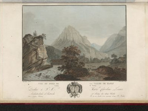
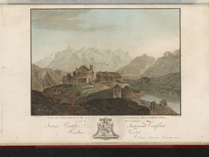
Worb Castle is located in the canton of Bern on the main road leading through the Emmental valley to Lucerne. This view was drawn near the fountain, which was located directly behind the castle. Samuel Wyttenbach, who wrote the text for the plates in this publication, reports that the pre-Alpine peaks of the Niesen and Stockhorn would also be covered in snow in summer - the climate at that time was therefore much cooler than it is today.

Around 1350, the then lord of Worb Castle, Baron von Kien, had the Biglenbach diverted to fill the castle moat. From then on, the canal, which still exists today, was also used to operate mills and all kinds of industries that used water power. This marked the beginning of the commercial and industrial development of Worb.


Aufnahmestandort
nb-482042
Ort auf moderner Karte
GEOMETRYCOLLECTION (POINT (7.568445 46.931464), LINESTRING (7.568445 46.931464, 7.567844 46.930952))
Camera Settings (3D)
{"landscape":{"image.scale":81,"viewpoint":{"bounds":[[7.53845230618677,46.91345190879761],[7.570403588339673,46.93296609648655]],"bearing":-136.5594052453285,"pitch":80.99999999999999,"zoom":18.15111173199696,"center":{"lng":7.567962706093795,"lat":46.93110509696564},"cam":{"center":{"lng":7.561720730931427,"lat":46.92320989115882},"zoom":14.38233067066032,"bearing":0},"cameraToCenterDistance":1791,"cameraPosition":{"lngLat":{"lng":7.570900735762649,"lat":46.93322366349295},"altitude":684.3399849315347},"cameraTargetElevation":632.9522215442669}},"portrait":{"viewpoint":{"bounds":[[7.543531421013853,46.918095899322765],[7.570001400239249,46.93270149569855]],"bearing":-136.56520105532627,"pitch":80.38159944172133,"zoom":18.062129508247835,"center":{"lng":7.568233609205436,"lat":46.93132305925877},"cameraToCenterDistance":1077.0165098970401,"cameraPosition":{"lngLat":{"lng":7.570109270879527,"lat":46.93267584732965},"altitude":664.5896392892339},"cameraTargetElevation":629.4839843461535},"camera.fov":58},"square":{"viewpoint":{"bounds":[[7.5508307726659325,46.92190080524088],[7.569605658931266,46.93233322871254]],"bearing":-138.96520105532642,"pitch":80.12248021601555,"zoom":18.55722971168377,"center":{"lng":7.5683918595325395,"lat":46.931335880539166},"cam":{"center":{"lng":7.5669583086799435,"lat":46.927117270953744},"zoom":14.496031797058478,"bearing":0},"cameraToCenterDistance":1077.0165098970401,"cameraPosition":{"lngLat":{"lng":7.569661651049216,"lat":46.93233214224395},"altitude":654.192893159871},"cameraTargetElevation":628.6205566393771}}}
Quellen

Jakob Samuel Wyttenbach, Vues remarquables des montagnes de la Suisse, dessinées et colorées d'après nature, Amsterdam 1785, pp. 1-2; https://www.myswitzerland.com/fr-ch/decouvrir/chemin-historique-de-worb/ [30.05.2023]

Bilder
nb-482048
Titel
View of Thun and the Aare at the outflow from Lake Thun
Text

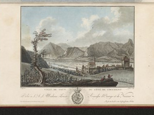
The location of this view - slightly north of today's hospital - still shows the vineyard that was located here. The small islands in the Aare can also be seen. The view of Thun from the south was taken on one of them.


Ort auf moderner Karte
GEOMETRYCOLLECTION (POINT (7.631947 46.762217), POINT (7.644253 46.762417), LINESTRING (7.631947 46.762217, 7.631893 46.761109))
Camera Settings (3D)
{"landscape":{"camera.fov":60,"viewpoint":{"bounds":[[7.612522455075663,46.76345170191186],[7.677059063027713,46.78651187988845]],"bearing":-170.19109304769802,"pitch":82.82289104174032,"zoom":18.36284219658108,"center":{"lng":7.6319469999955345,"lat":46.76221700000161},"cam":{"center":{"lng":7.658640642129313,"lat":46.77603693768481},"zoom":13.835760490623704,"bearing":0},"cameraToCenterDistance":1107.646491440297,"cameraPosition":{"lngLat":{"lng":7.632337504145028,"lat":46.76376423908124},"altitude":604.1516740629457},"cameraTargetElevation":582.1653995972307}},"portrait":{"viewpoint":{"bounds":[[7.612477029796565,46.76345151656588],[7.677161772063727,46.78656430946032]],"bearing":-170.1910930477832,"pitch":82.81728611002535,"zoom":18.362824417854448,"center":{"lng":7.631946999995307,"lat":46.7622170000017},"cameraToCenterDistance":1107.646491440297,"cameraPosition":{"lngLat":{"lng":7.6323375041448,"lat":46.76376423908138},"altitude":604.1690252972195},"cameraTargetElevation":582.1653995972307}},"square":{"viewpoint":{"bounds":[[7.612477029670828,46.76345151656548],[7.677161772352122,46.78656430961237]],"bearing":-170.1910930477832,"pitch":82.81728611002535,"zoom":18.362824417854448,"center":{"lng":7.631946999994966,"lat":46.76221700000124},"cam":{"center":{"lng":7.935900743077298,"lat":46.79715475579593},"zoom":9.44228382510442,"bearing":0},"cameraToCenterDistance":1107.646491440297,"cameraPosition":{"lngLat":{"lng":7.632337504144431,"lat":46.76376423908093},"altitude":604.1690252972196},"cameraTargetElevation":582.1653995972307}},"null":{"viewpoint":{"bounds":[[7.612522455086065,46.76345170191172],[7.677059063022966,46.78651187988626]],"bearing":-170.19109304769802,"pitch":82.82289104174032,"zoom":18.36284219658108,"center":{"lng":7.631946999995876,"lat":46.76221700000144},"cam":{"center":{"lng":7.6586406421289155,"lat":46.776036937683386},"zoom":13.835760490962763,"bearing":0},"cameraToCenterDistance":1107.646491440297,"cameraPosition":{"lngLat":{"lng":7.632337504145482,"lat":46.7637642390811},"altitude":604.1516740629459},"cameraTargetElevation":582.1653995972307}}}
Quellen

Jakob Samuel Wyttenbach, Vues remarquables des montagnes de la Suisse, dessinées et colorées d'après nature, Amsterdam 1785, p. 5

Bilder
nb-482076
Titel
View from the Schlossberg in Thun towards Lake Thun and the Niesen
Text

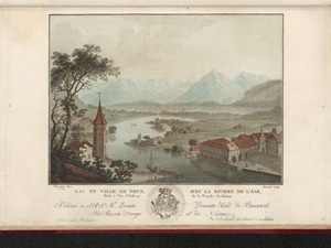
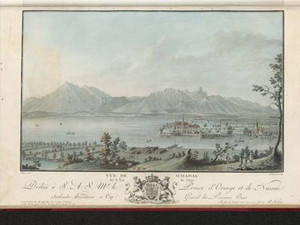
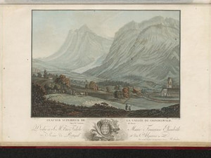
In the 18th century, the town of Thun was the starting point for travelers coming to the Bernese Oberland. Postal boats ran from the landing stage to Bern, which took two hours. There were also mail boats to Unterseen twice a week, from where passengers traveled on to the valleys of Lauterbrunnen and Grindelwald. You could also take a mail boat across Lake Brienz to Brienz to visit Meiringen and the Haslital. If you wanted to hire your own ship with two boatmen to cross Lake Thun to Neuhaus near Interlaken in four hours, this cost two and a half guilders in 1810, which corresponds to around 450 Swiss francs in 2023.


Aufnahmestandort
nb-482076
Ort auf moderner Karte
GEOMETRYCOLLECTION (POINT (7.631603 46.758793), LINESTRING (7.631603 46.758793, 7.63162 46.758716))
Camera Settings (3D)
{"landscape":{"viewpoint":{"bounds":[[7.379096209404423,46.759291685974716],[7.9071024099328895,46.96879106128057]],"bearing":168.34744802153682,"pitch":80.52705482229703,"zoom":17.100737192497512,"center":{"lng":7.63229012489478,"lat":46.7566494824938},"cam":{"center":{"lng":7.760641771840909,"lat":46.87307253504147},"zoom":10.75052416864417,"bearing":0},"cameraToCenterDistance":1107.646491440297,"cameraPosition":{"lngLat":{"lng":7.631186208298573,"lat":46.76031664274916},"altitude":627.3037143149159},"cameraTargetElevation":557.8301757825279},"image.scale":53},"portrait":{"viewpoint":{"bounds":[[7.3790962054901,46.759291685973636],[7.907102414157748,46.96879106447676]],"bearing":168.34744802153682,"pitch":80.52705482229703,"zoom":17.100737192497512,"center":{"lng":7.632290124894439,"lat":46.75664948249249},"cameraToCenterDistance":1107.646491440297,"cameraPosition":{"lngLat":{"lng":7.63118620829826,"lat":46.76031664274785},"altitude":627.3037143149176},"cameraTargetElevation":557.8301757825279}},"square":{"viewpoint":{"bounds":[[7.379096207494143,46.75929168597406],[7.90710241189899,46.96879106281443]],"bearing":168.34744802153682,"pitch":80.52705482229703,"zoom":17.100737192497512,"center":{"lng":7.632290124894325,"lat":46.756649482493174},"cam":{"center":{"lng":10.019127229518318,"lat":47.044347138232695},"zoom":6.413226308960023,"bearing":0},"cameraToCenterDistance":1107.646491440297,"cameraPosition":{"lngLat":{"lng":7.631186208298146,"lat":46.760316642748506},"altitude":627.3037143149168},"cameraTargetElevation":557.8301757825279}}}
Quellen

Jakob Samuel Wyttenbach, Vues remarquables des montagnes de la Suisse, dessinées et colorées d'après nature, Amsterdam 1785, p. 2; Johann Gottfried Ebel, Anleitung, auf nützlichste und genussvollste Art die Schweitz zu bereisen, vol. 4, Zurich 1810, p. 339

Bilder
nb-482043
Ort
GEOMETRYCOLLECTION (POINT (7.633616 46.754244), LINESTRING (7.633616 46.754244, 7.630184 46.760212))
Titel
View of Thun from the south
Text

Thun was not only the starting point for the trip to the Bernese Oberland, but also offered its own sights. Thun Castle, for example, with its mighty donjon and four corner towers, was built around 1200 under Berchthold V of Zähringen. Not far away, on the same hill, stands the town church, whose tower is octagonal at the top. The accompanying text mentions the beautiful view over Lake Thun and the mountains to the south, which can be enjoyed by climbing up to the castle terrace, which is also recommended by all contemporary travel guides.


Aufnahmestandort
nb-482043
Ort auf moderner Karte
GEOMETRYCOLLECTION (POINT (7.63344 46.754639), LINESTRING (7.63344 46.754639, 7.632258 46.756824))
Camera Settings (3D)
{"landscape":{"viewpoint":{"bounds":[[7.6254209225671445,46.74283664140589],[7.646851168430942,46.753881750619996]],"bearing":-25.192185365802057,"pitch":84.5,"zoom":18.912742220183212,"center":{"lng":7.6334381103649775,"lat":46.75462259666182},"cam":{"center":{"lng":7.642319729887106,"lat":46.748830264013776},"zoom":14.999095695673857,"bearing":0},"cameraToCenterDistance":1107.646491440297,"cameraPosition":{"lngLat":{"lng":7.634106739996895,"lat":46.75364874305487},"altitude":570.6635181523955},"cameraTargetElevation":559.1406982423059},"image.scale":36},"portrait":{"viewpoint":{"bounds":[[7.625420922369699,46.74283664118565],[7.646851168681309,46.753881750624146]],"bearing":-25.192185365802057,"pitch":84.5,"zoom":18.912742220183212,"center":{"lng":7.633438110361567,"lat":46.75462259666605},"cameraToCenterDistance":1107.646491440297,"cameraPosition":{"lngLat":{"lng":7.6341067399934275,"lat":46.7536487430591},"altitude":570.6635181523945},"cameraTargetElevation":559.1406982423059},"image.scale":37},"square":{"viewpoint":{"bounds":[[7.625420922247457,46.74283664102154],[7.64685116887992,46.753881750624856]],"bearing":-25.192185365802057,"pitch":84.5,"zoom":18.912742220183212,"center":{"lng":7.633438110361794,"lat":46.754622596666906},"cam":{"center":{"lng":7.732572155409798,"lat":46.7557010223959},"zoom":11.036060832571977,"bearing":0},"cameraToCenterDistance":1107.646491440297,"cameraPosition":{"lngLat":{"lng":7.634106739993655,"lat":46.753648743059955},"altitude":570.6635181523943},"cameraTargetElevation":559.1406982423059},"image.scale":39}}
Quellen

Volker Herrmann, Leta Büchi, Schloss Thun, neue Erkenntnisse zur Baugeschichte von Burg und Schloss, in: Mittelalter. Zeitschrift des Schweizerischen Burgenvereins, 19th vol. 2014/4, p. 123; Jakob Samuel Wyttenbach, Vues remarquables des montagnes de la Suisse, dessinées et colorées d'après nature, Amsterdam 1785, p. 2

Bilder
nb-482047
Titel
View of Schadau Castle near Thun
Text

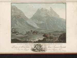
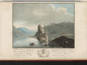
Schadau Castle, which had belonged to the von Bubenberg family since 1348, was situated at the outflow of the River Aare from Lake Thun. It served as the "Sässhaus" of the Strättligen estate. The building you see here was built from 1638 under the then owner Franz Ludwig von Erlach. Today, a neo-Gothic villa from the mid-19th century stands in its place in the middle of an extensive landscaped park.


Aufnahmestandort
nb-482047
Ort auf moderner Karte
GEOMETRYCOLLECTION (POINT (7.643899 46.74796), LINESTRING (7.643899 46.74796, 7.643791 46.747872))
Camera Settings (3D)
{"landscape":{"viewpoint":{"bounds":[[7.6185246763458,46.74751948476137],[7.874156231279898,46.87477930557753]],"bearing":-150.89243978071295,"pitch":82.00000000000001,"zoom":17.541594695960608,"center":{"lng":7.642219662666321,"lat":46.74561737717423},"cam":{"center":{"lng":7.81767096977012,"lat":46.81661108844867},"zoom":11.471114878456238,"bearing":0},"cameraToCenterDistance":1255.0894182705438,"cameraPosition":{"lngLat":{"lng":7.644447854687854,"lat":46.74835965201254},"altitude":614.6411650150271},"cameraTargetElevation":565.590624999978},"image.scale":26,"camera.fov":54},"portrait":{"viewpoint":{"bounds":[[7.58570200367393,46.71652470425727],[7.644265757785263,46.75506541333914]],"bearing":-132.68358508766153,"pitch":75.99999999999999,"zoom":19.18715791161565,"center":{"lng":7.643320709466934,"lat":46.747590384067934},"cameraToCenterDistance":1150.0817362257346,"cameraPosition":{"lngLat":{"lng":7.644286998288891,"lat":46.748201010942665},"altitude":608.626119092379},"cameraTargetElevation":583.6550048831831},"image.scale":14},"square":{"viewpoint":{"bounds":[[7.604119592982016,46.72650784427316],[7.6441436061871855,46.75284568556742]],"bearing":-132.68358508766153,"pitch":75.99999999999999,"zoom":19.736300128998966,"center":{"lng":7.643497735261917,"lat":46.74773695528941},"cam":{"center":{"lng":7.695285400838202,"lat":46.745096179758406},"zoom":11.474693455555776,"bearing":0},"cameraToCenterDistance":1150.0817362257346,"cameraPosition":{"lngLat":{"lng":7.644158122506639,"lat":46.74815427340042},"altitude":604.5418934265192},"cameraTargetElevation":587.4760223388687},"image.scale":14,"camera.fov":60}}
Quellen

Jakob Samuel Wyttenbach, Vues remarquables des montagnes de la Suisse, dessinées et colorées d'après nature, Amsterdam 1785, p. 5; Anne-Marie Dubler, "Scherzligen", in: Historisches Lexikon der Schweiz (HLS), version of 11.09.2012 [13.11.2023])


Bilder
nb-482075
Ort
GEOMETRYCOLLECTION (POINT (7.445347 46.460313), LINESTRING (7.445347 46.460313, 7.523061 46.372927))
Titel
View towards Lenk with the Wildstrubel
Text

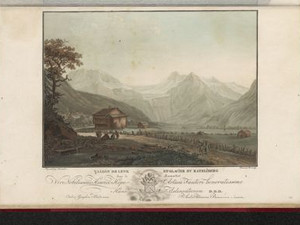
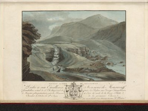
"The highest part of the 13-hour-long Simme valley is one of the most picturesque and remarkable mountain regions, whose beauties are little known and visited, although travelers from Thun to here can travel comfortably on small carriages [...]." According to Ebel, the three falls of the Simme are particularly recommended, all of which can be visited in one morning - provided you set off at four or five in the morning.


Aufnahmestandort
nb-482075
Ort auf moderner Karte
GEOMETRYCOLLECTION (POINT (7.442512 46.460648), LINESTRING (7.442512 46.460648, 7.44416 46.458628))
Camera Settings (3D)
{"landscape":{"viewpoint":{"bounds":[[7.418742430746789,46.46191246761268],[7.461291647781394,46.48162805879184]],"bearing":160.9126161328502,"pitch":84.00000000000003,"zoom":18.250732760744526,"center":{"lng":7.442499697201242,"lat":46.460666242600865},"cam":{"center":{"lng":7.45099873294194,"lat":46.47261150755426},"zoom":14.170533712971897,"bearing":0},"cameraToCenterDistance":1107.646491440297,"cameraPosition":{"lngLat":{"lng":7.4416876320839265,"lat":46.46228280030786},"altitude":1086.2032032616316},"cameraTargetElevation":1066.210937466753}},"portrait":{"viewpoint":{"bounds":[[7.4187424307670256,46.46191246761475],[7.4612916477614135,46.48162805877698]],"bearing":160.9126161328502,"pitch":84.00000000000003,"zoom":18.250732760744526,"center":{"lng":7.442499697200674,"lat":46.46066624260297},"cameraToCenterDistance":1107.646491440297,"cameraPosition":{"lngLat":{"lng":7.4416876320833865,"lat":46.462282800309936},"altitude":1086.2032032616307},"cameraTargetElevation":1066.210937466753}},"square":{"viewpoint":{"bounds":[[7.418742430974305,46.46191246761646],[7.461291647585568,46.481628058608294]],"bearing":160.9126161328502,"pitch":84.00000000000003,"zoom":18.250732760744526,"center":{"lng":7.442499697200219,"lat":46.460666242604674},"cam":{"center":{"lng":7.631488514030622,"lat":46.48642125896086},"zoom":10.046576715919226,"bearing":0},"cameraToCenterDistance":1107.646491440297,"cameraPosition":{"lngLat":{"lng":7.441687632082903,"lat":46.46228280031164},"altitude":1086.2032032616303},"cameraTargetElevation":1066.210937466753}}}
Quellen

Johann Gottfried Ebel, Anleitung, auf nützlichste und genussvollste Art die Schweitz zu bereisen, vol. 3, Zurich 1810, p. 319
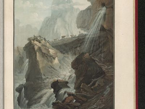
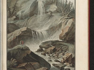
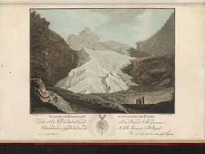
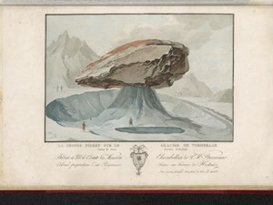
Bilder
nb-482083
Ort
GEOMETRYCOLLECTION (POINT (7.339038 46.37037), LINESTRING (7.339038 46.37037, 7.340672 46.368414))
Titel
View of the Geltenschuss above Lake Lauenen
Text

Back in 1810, Johann Gottfried Ebel praised Lake Lauenen as a "magnificent viewpoint". Further up the valley, however, there are more sights to see: "From this magnificent viewpoint, a path leads up to the Gelten glacier in 4 hours, a rather arduous climb, and past the magnificent waterfalls of the Tungel and Gelten streams. Up at the foot of the glacier is an alpine meadow surrounded by steep rock faces, over which a number of streams tumble down, a unique sight."

Ort auf moderner Karte
GEOMETRYCOLLECTION (POINT (7.330558 46.378154), LINESTRING (7.330558 46.378154, 7.330703 46.378021))
Camera Settings (3D)
{"landscape":{"camera.fov":50,"image.scale":168,"viewpoint":{"bounds":[[7.1208450005633495,46.37754855931141],[7.429833681069482,46.5667267769316]],"bearing":152.51354780995075,"pitch":85,"zoom":15.396743143400696,"center":{"lng":7.3387491703001615,"lat":46.36739398573289},"cam":{"center":{"lng":7.380713521309929,"lat":46.480282807069585},"zoom":10.908184781444698,"bearing":0},"cameraToCenterDistance":1371.4121756658628,"cameraPosition":{"lngLat":{"lng":7.328472048088912,"lat":46.3810228720119},"altitude":2166.494088379812},"cameraTargetElevation":2017.0187500016948}},"portrait":{"viewpoint":{"bounds":[[6.921723024387262,46.37915660312507],[7.519477798685983,46.744802893430744]],"bearing":152.1909265119042,"pitch":84,"zoom":15.137188120405401,"center":{"lng":7.338448762888902,"lat":46.36773453350452},"cameraToCenterDistance":1371.4121756658628,"cameraPosition":{"lngLat":{"lng":7.326033848275301,"lat":46.38397394208181},"altitude":2202.1539249881525},"cameraTargetElevation":1987.5492184078214},"image.scale":282},"square":{"viewpoint":{"bounds":[[6.921723023844123,46.37915660312419],[7.519477798922338,46.74480289392022]],"bearing":152.1909265119042,"pitch":84,"zoom":15.137188120405401,"center":{"lng":7.3384487628886745,"lat":46.36773453350355},"cam":{"center":{"lng":9.910496899235056,"lat":46.76739646120282},"zoom":6.234227441471939,"bearing":0},"cameraToCenterDistance":1371.4121756658628,"cameraPosition":{"lngLat":{"lng":7.326033848275017,"lat":46.38397394208084},"altitude":2202.1539249881566},"cameraTargetElevation":1987.5492184078214},"image.scale":313}}
Quellen

Johann Gottfried Ebel, Anleitung, auf die nützlichste und genussvollste Art die Schweitz zu bereisen, vol. 3, Zurich 1810, pp. 271-272

Bilder
nb-482050
Ort
GEOMETRYCOLLECTION (POINT (7.782183 46.684305), LINESTRING (7.782183 46.684305, 7.772999 46.682892))
Titel
At the Beatus Caves on Lake Thun
Text

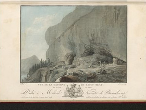
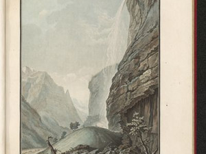
These caves were already visited by travelers in the Middle Ages. According to legend, a hermit named Beatus, who had come from France or England, lived here in the 2nd century AD. After driving away a dragon and converting the locals to Christianity, he made the caves his home and supposedly died in 112 AD at the age of 100. His grave in the caves then became a pilgrimage destination.

After the Reformation, the Bernese government tried everything in its power to stop the pilgrimage. However, pilgrims continued to come from central Switzerland in particular, constantly breaking down the wall erected by the Bernese at the entrance to the cave. In the 18th century, visitors were then taken by boat to Merligen and climbed up to the cave from there, while the boats continued on to Sundlauenen, where they picked up the tourists again and transported them on to Neuhaus.


Ort auf moderner Karte
GEOMETRYCOLLECTION (POINT (7.782359 46.684498), LINESTRING (7.782359 46.684498, 7.782226 46.684536))
Camera Settings (3D)
{"landscape":{"viewpoint":{"bounds":[[7.788662381352935,46.62516201219904],[7.864063238233655,46.706558184379475]],"bearing":-79.43547026901956,"pitch":85,"zoom":16.926208110339317,"center":{"lng":7.782445549964905,"lat":46.68462902717792},"cam":{"center":{"lng":7.871863464650119,"lat":46.66934474056998},"zoom":12.119746978458267,"bearing":0},"cameraToCenterDistance":1371.4121756658628,"cameraPosition":{"lngLat":{"lng":7.7900282451127225,"lat":46.68365885482396},"altitude":773.3999118057668},"cameraTargetElevation":721.9222900390623},"image.scale":118},"portrait":{"viewpoint":{"bounds":[[7.784431681458642,46.64773249340311],[7.831942764880495,46.70055632524455]],"bearing":-82.07935684522448,"pitch":85,"zoom":17.560594362554163,"center":{"lng":7.780369520181921,"lat":46.68477990957243},"cameraToCenterDistance":1371.4121756658628,"cameraPosition":{"lngLat":{"lng":7.785291230063621,"lat":46.684310160250675},"altitude":746.7291554227123},"cameraTargetElevation":713.5666013723013}},"square":{"viewpoint":{"bounds":[[7.784431681464298,46.647732493664904],[7.831942764557397,46.700556325117844]],"bearing":-82.07935684522448,"pitch":85,"zoom":17.560594362554163,"center":{"lng":7.780369520187833,"lat":46.68477990957078},"cam":{"center":{"lng":8.021987096929877,"lat":46.690448189999756},"zoom":9.88744519037965,"bearing":0},"cameraToCenterDistance":1371.4121756658628,"cameraPosition":{"lngLat":{"lng":7.785291230069589,"lat":46.684310160249055},"altitude":746.7291554227133},"cameraTargetElevation":713.5666013723013}}}
Quellen

Rainald Fischer, "Beatus", in: Historisches Lexikon der Schweiz (HLS), version of 10.06.2004 [12.04.2024]; Gottfried Buchmüller, Beatenhöhlen, Beatenverehrung und Beatenkirchlein. Was sie aus alten und neuen Tagen zu erzählen wissen, in: Berner Zeitschrift für Geschichte und Altertumskunde, vol. 7 (1945), pp. 72-89 [12.04.2024]; Johann Gottfried Ebel, Anleitung, auf die nützlichste und genussvollste Art die Schweitz zu bereisen, vol. 4, Zurich 1810, pp. 343-344

Bilder
nb-482051
Ort
GEOMETRYCOLLECTION (POINT (7.87205 46.694137), LINESTRING (7.87205 46.694137, 7.866201 46.691769))
Titel
View of Interlaken on Lake Brienz
Text

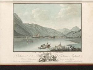
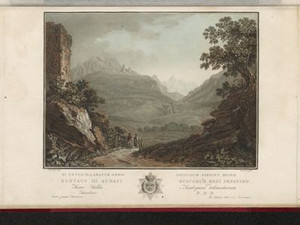
Augustinian canons lived here from 1133 at the latest. Nuns also lived in the same convent from at least 1247. This led to such a decline in morals that the women's convent was dissolved in 1484. After the Reformation, the convent developed into today's Interlaken Castle, with only a few parts of the church and convent buildings still standing.

The fertile plain lay between Lakes Thun and Brienz and was named "inter Lacus", which means "between the lakes". Despite its location in the Alps, the mild climate made it possible to grow fruit trees. Johann Gottfried Ebel reported that the largest walnut trees in Switzerland grew here.

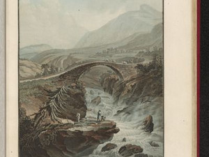
The covered Aare bridge on the right of the picture is part of the route over the Grimsel Pass to Italy and into central Switzerland via the Brünig. The high volume of traffic brought in large revenues from the bridge toll, which had to be paid at the customs house at the left end of the bridge.


Ort auf moderner Karte
GEOMETRYCOLLECTION (POINT (7.883538 46.694429), LINESTRING (7.883538 46.694429, 7.882889 46.694252))
Camera Settings (3D)
{"landscape":{"viewpoint":{"bounds":[[7.837941523124158,46.67367390238746],[7.884863054628568,46.70805526325543]],"bearing":-105.10453105764897,"pitch":82.5,"zoom":17.780712863950193,"center":{"lng":7.8802871704169775,"lat":46.6940234124896},"cam":{"center":{"lng":7.87356930669975,"lat":46.690867318603466},"zoom":13.710714679216206,"bearing":0},"cameraToCenterDistance":1992,"cameraPosition":{"lngLat":{"lng":7.886240956441014,"lat":46.69512560580935},"altitude":625.4736129121798},"cameraTargetElevation":563.5531250022784},"image.scale":68},"portrait":{"viewpoint":{"bounds":[[7.637939365945073,46.56849590670137],[7.8870970220474135,46.80518151672308]],"bearing":-105.10453105867964,"pitch":79.49847479932657,"zoom":17.634097026761502,"center":{"lng":7.883560806512833,"lat":46.694500815585684},"cameraToCenterDistance":1371.4121756658628,"cameraPosition":{"lngLat":{"lng":7.888060708636289,"lat":46.69533385368186},"altitude":631.0318013838046},"cameraTargetElevation":565.138281250129},"image.scale":69},"square":{"viewpoint":{"bounds":[[7.637939364660923,46.56849590515043],[7.887097022048266,46.805181517289924]],"bearing":-105.10453105867964,"pitch":79.49847479932657,"zoom":17.634097026761502,"center":{"lng":7.883560806513401,"lat":46.69450081558665},"cam":{"center":{"lng":8.883727651597582,"lat":46.77235981466109},"zoom":7.4967222780225145,"bearing":0},"cameraToCenterDistance":1371.4121756658628,"cameraPosition":{"lngLat":{"lng":7.8880607086368855,"lat":46.695333853682854},"altitude":631.0318013838034},"cameraTargetElevation":565.138281250129}},"null":{"image.scale":47,"viewpoint":{"bounds":[[7.771773913607319,46.63719901210439],[7.8841364265065295,46.74122857825239]],"bearing":-106.70453105881614,"pitch":78.49853877408431,"zoom":18.25811647978875,"center":{"lng":7.881881743678832,"lat":46.6941255164092},"cam":{"center":{"lng":7.86590224449759,"lat":46.69213098364992},"zoom":12.381645623319773,"bearing":0},"cameraToCenterDistance":1371.4121756658628,"cameraPosition":{"lngLat":{"lng":7.884768598846591,"lat":46.694719734392436},"altitude":611.9130322094996},"cameraTargetElevation":565.138281250129}}}
Quellen

Jakob Samuel Wyttenbach, Vues remarquables des montagnes de la Suisse, Amsterdam 1785, p. 7; Johann Gottfried Ebel, Anleitung, auf die nützlichste und genussvollste Art die Schweitz zu bereisen, Bd. 3, Zurich 1810, p. 215; Barbara Studer, "Interlaken (Kloster, Amtsbezirk)", in: Historisches Lexikon der Schweiz (HLS), version of 11.01.2018 [13.11.2023]

Bilder
nb-482052
Titel
View of Ringgenberg on Lake Brienz
Text

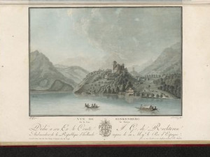
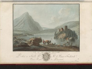
About half an hour before the western end of the lake, the ruins of Ringgenberg Castle on a spur of land on the shore presented themselves to travelers on Lake Brienz from the Oberhasli Valley towards Unterseen and Interlaken. It was built around 1231 by the lords of Brienz-Raron. In 1381, the subjects burned the castle down and it was never rebuilt. The Bernese authorities built a reformed church in the ruins between 1670 and 1671.


Aufnahmestandort
nb-482052
Ort auf moderner Karte
GEOMETRYCOLLECTION (POINT (7.901616 46.702578), LINESTRING (7.901616 46.702578, 7.899234 46.701651))
Camera Settings (3D)
{"landscape":{"viewpoint":{"bounds":[[7.904380244752986,46.68788764090041],[7.965932605176988,46.735844150191554]],"bearing":-116.84170898420173,"pitch":84.99743864185135,"zoom":17.550108079778102,"center":{"lng":7.90104149926924,"lat":46.70245091210879},"cam":{"center":{"lng":7.961987066571027,"lat":46.71391528346024},"zoom":12.881752733104596,"bearing":0},"cameraToCenterDistance":1371.4121756658628,"cameraPosition":{"lngLat":{"lng":7.905507556132392,"lat":46.7040008031486},"altitude":598.9106100078758},"cameraTargetElevation":565.5},"image.scale":39},"portrait":{"viewpoint":{"bounds":[[7.904380244749319,46.687887641080124],[7.965932604492735,46.73584414977884]],"bearing":-116.84170898420173,"pitch":84.99743864185135,"zoom":17.550108079778102,"center":{"lng":7.901041499265517,"lat":46.702450912108674},"cameraToCenterDistance":1371.4121756658628,"cameraPosition":{"lngLat":{"lng":7.905507556128583,"lat":46.70400080314843},"altitude":598.9106100078759},"cameraTargetElevation":565.5},"image.scale":40},"square":{"viewpoint":{"bounds":[[7.90438024474912,46.687887640881996],[7.965932605252334,46.73584415016214]],"bearing":-116.84170898420173,"pitch":84.99743864185135,"zoom":17.550108079778102,"center":{"lng":7.901041499265261,"lat":46.70245091210731},"cam":{"center":{"lng":8.21214204726519,"lat":46.732969324826996},"zoom":9.513895101677653,"bearing":0},"cameraToCenterDistance":1371.4121756658628,"cameraPosition":{"lngLat":{"lng":7.905507556128441,"lat":46.704000803147096},"altitude":598.9106100078768},"cameraTargetElevation":565.5},"image.scale":40}}
Quellen

Jakob Samuel Wyttenbach, Vues remarquables des montagnes de la Suisse, Amsterdam 1785, p. 8; Anne-Marie Dubler, "Ringgenberg", in: Historisches Lexikon der Schweiz (HLS), version of 20.08.2013 [13.11.2023]

Bilder
nb-482056
Ort
GEOMETRYCOLLECTION (POINT (7.876386 46.645312), LINESTRING (7.876386 46.645312, 7.877624 46.64508))
Titel
View of a bridge over the Lütschinen
Text

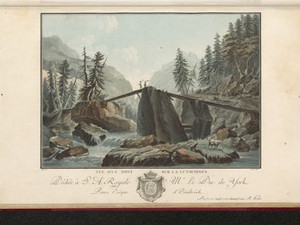
The path to Zweilütschinen and Lauterbrunnen shown here led over this bridge made of wooden planks. For travelers, the crossing was a real test of courage in contrast to the inhabitants of the valley, who walked across the bridge every day and crossed it with sure steps.

Ort auf moderner Karte
GEOMETRYCOLLECTION (POINT (7.868743 46.652824), LINESTRING (7.868743 46.652824, 7.86989 46.652679))
Camera Settings (3D)
{"landscape":{"viewpoint":{"bounds":[[7.84304112447424,46.653463196896325],[7.876361157369615,46.674868569472295]],"bearing":145.2883668497483,"pitch":85,"zoom":18.107979096520605,"center":{"lng":7.869292795662318,"lat":46.65221358769614},"cam":{"center":{"lng":7.867513469489239,"lat":46.66476264968048},"zoom":14.661809755730337,"bearing":0},"cameraToCenterDistance":1228.4680701980606,"cameraPosition":{"lngLat":{"lng":7.867558398118177,"lat":46.65393216418994},"altitude":636.0379290010169},"cameraTargetElevation":615.6990843283038},"camera.fov":55},"portrait":{"viewpoint":{"bounds":[[7.842435499054943,46.65346053596872],[7.876972023936929,46.675769672275436]],"bearing":145.2883668497483,"pitch":85,"zoom":18.107979096520605,"center":{"lng":7.869292795662432,"lat":46.652213587695},"cameraToCenterDistance":1228.4680701980606,"cameraPosition":{"lngLat":{"lng":7.867558398118206,"lat":46.6539321641888},"altitude":636.0379290010173},"cameraTargetElevation":615.6990843283038}},"square":{"viewpoint":{"bounds":[[7.842435498842718,46.65346053597037],[7.87697202400193,46.67576967244895]],"bearing":145.2883668497483,"pitch":85,"zoom":18.107979096520605,"center":{"lng":7.869292795660613,"lat":46.65221358769659},"cam":{"center":{"lng":8.015118124638832,"lat":46.67646560639335},"zoom":10.347586350537622,"bearing":0},"cameraToCenterDistance":1228.4680701980606,"cameraPosition":{"lngLat":{"lng":7.867558398116358,"lat":46.653932164190394},"altitude":636.0379290010168},"cameraTargetElevation":615.6990843283038}}}
Quellen

Jakob Samuel Wyttenbach, Vues remarquables des montagnes de la Suisse, Amsterdam 1785, p. 10

Bilder
nb-482044
Ort
GEOMETRYCOLLECTION (POINT (7.909684 46.593895), LINESTRING (7.909684 46.593895, 7.903805 46.57666))
Titel
View of the Staubbach Falls near Lauterbrunnen
Text

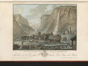
One of the most important sights in the Bernese Oberland was the Staubbach in the Lauterbrunnen Valley. With a drop of 297 meters, it is the highest free-falling waterfall in Switzerland: it got its name because the water dissolves into tiny droplets as it falls and forms rainbows in the sunlight. This play of light inspired Johann Wolfgang Goethe to write his famous poem Gesang der Geister über den Wassern during his trip to the Lauterbunnen Valley in 1779.

Ort auf moderner Karte
GEOMETRYCOLLECTION (POINT (7.910186 46.593534), LINESTRING (7.910186 46.593534, 7.909867 46.592507))
Camera Settings (3D)
{"landscape":{"camera.fov":60,"viewpoint":{"bounds":[[7.89956930904421,46.59525920862936],[7.93367166883192,46.607227429769324]],"bearing":-172.20887242484724,"pitch":85,"zoom":18.108911514606067,"center":{"lng":7.910227328553901,"lat":46.5936660386418},"cam":{"center":{"lng":7.923939028147345,"lat":46.60180235361952},"zoom":14.756006669149256,"bearing":0},"cameraToCenterDistance":1107.646491440297,"cameraPosition":{"lngLat":{"lng":7.91059936958294,"lat":46.59553448253243},"altitude":809.238659633604},"cameraTargetElevation":790.892187705357}},"portrait":{"viewpoint":{"bounds":[[7.899569308993506,46.595259208629415],[7.933671668941315,46.60722742982418]],"bearing":-172.20887242484724,"pitch":85,"zoom":18.108911514606067,"center":{"lng":7.9102273285549245,"lat":46.5936660386418},"cameraToCenterDistance":1107.646491440297,"cameraPosition":{"lngLat":{"lng":7.910599369583991,"lat":46.59553448253243},"altitude":809.238659633604},"cameraTargetElevation":790.892187705357}},"square":{"viewpoint":{"bounds":[[7.899569309050008,46.59525920863146],[7.933671668797842,46.60722742976995]],"bearing":-172.20887242484724,"pitch":85,"zoom":18.108911514606067,"center":{"lng":7.910227328556402,"lat":46.593666038643875},"cam":{"center":{"lng":8.070081107789207,"lat":46.61295776687939},"zoom":10.36583771463456,"bearing":0},"cameraToCenterDistance":1107.646491440297,"cameraPosition":{"lngLat":{"lng":7.910599369585412,"lat":46.59553448253453},"altitude":809.2386596336033},"cameraTargetElevation":790.892187705357}}}
Quellen

Jakob Samuel Wyttenbach, Vues remarquables des montagnes de la Suisse, dessinées et colorées d'après nature, Amsterdam 1785, p. 3; https://lauterbrunnen.swiss/fileadmin/lauterbrunnen/Allgemein/Goethe_Gedicht_1779.pdf [29.9.2023]

Bilder
nb-482045
Ort
GEOMETRYCOLLECTION (POINT (7.902389 46.589305), LINESTRING (7.902389 46.589305, 7.89685 46.58803))
Titel
View of the upper Staubbach Falls
Text

"A little higher up, the same stream forms a fall that is invisible from the depths, little visited but very beautiful, and can be reached in an hour and a half without danger. You stand in a not very deep cave, called Staubbachbalm, over which two arms of water plunge like curtains, and you can see the valley below you and, at certain times of day, a rainbow, with the Jungfrau rising into the clouds opposite."


Ort auf moderner Karte
GEOMETRYCOLLECTION (POINT (7.904406 46.589069), LINESTRING (7.904406 46.589069, 7.903177 46.588936))
Camera Settings (3D)
{"landscape":{"camera.fov":60,"image.scale":146,"viewpoint":{"bounds":[[7.906662735850119,46.58152439447338],[7.943868215625514,46.61017840115113]],"bearing":-124.61351388257765,"pitch":85,"zoom":17.55107053123556,"center":{"lng":7.904212474827091,"lat":46.588755723890614},"cam":{"center":{"lng":7.941262424714552,"lat":46.597074627422955},"zoom":13.627837514677465,"bearing":0},"cameraToCenterDistance":1107.646491440297,"cameraPosition":{"lngLat":{"lng":7.907537388429034,"lat":46.59033279907308},"altitude":1190.1033875447085},"cameraTargetElevation":1163.0937487703404}},"portrait":{"image.scale":114,"viewpoint":{"bounds":[[7.90666273584992,46.58152439446897],[7.943868215632023,46.61017840114758]],"bearing":-124.61351388257765,"pitch":85,"zoom":17.55107053123556,"center":{"lng":7.904212474826977,"lat":46.5887557238901},"cameraToCenterDistance":1107.646491440297,"cameraPosition":{"lngLat":{"lng":7.907537388429006,"lat":46.59033279907257},"altitude":1190.1033875447088},"cameraTargetElevation":1163.0937487703404}},"square":{"image.scale":162,"viewpoint":{"bounds":[[7.906662735849125,46.58152439447082],[7.943868215630232,46.610178401149255]],"bearing":-124.61351388257765,"pitch":85,"zoom":17.55107053123556,"center":{"lng":7.904212474826181,"lat":46.5887557238901},"cam":{"center":{"lng":8.092690134754633,"lat":46.60863447254758},"zoom":10.240194162867581,"bearing":0},"cameraToCenterDistance":1107.646491440297,"cameraPosition":{"lngLat":{"lng":7.90753738842821,"lat":46.59033279907257},"altitude":1190.1033875447088},"cameraTargetElevation":1163.0937487703404}}}
Quellen

Heinrich Heidegger, Handbook for travelers in Switzerland, 4th edition, Zurich 1818, pp. 288-289

Bilder
nb-482046
Ort
GEOMETRYCOLLECTION (POINT (7.903846 46.59119), LINESTRING (7.903846 46.59119, 7.904616 46.586913))
Titel
View of the lower Staubbach Falls near Lauterbrunnen
Text

Click on "Open image details" for more information.

Aufnahmestandort
nb-482046
Ort auf moderner Karte
GEOMETRYCOLLECTION (POINT (7.905784 46.591886), LINESTRING (7.905784 46.591886, 7.905806 46.590898))
Camera Settings (3D)
{"landscape":{"viewpoint":{"bounds":[[7.891157976010248,46.59416764185988],[7.940181308248356,46.61172957489967]],"bearing":-170.69874202650237,"pitch":85,"zoom":17.579600012278263,"center":{"lng":7.905783999996174,"lat":46.5918859999955},"cam":{"center":{"lng":7.92619029763199,"lat":46.603752449320694},"zoom":14.23240969118898,"bearing":0},"cameraToCenterDistance":1107.646491440297,"cameraPosition":{"lngLat":{"lng":7.906424178189354,"lat":46.59457202126123},"altitude":928.8274162406263},"cameraTargetElevation":902.3481793929373},"image.scale":112},"portrait":{"image.scale":107,"viewpoint":{"bounds":[[7.891157975955053,46.59416764185977],[7.940181308366306,46.611729574960094]],"bearing":-170.69874202650237,"pitch":85,"zoom":17.579600012278263,"center":{"lng":7.905783999997766,"lat":46.591885999995355},"cameraToCenterDistance":1107.646491440297,"cameraPosition":{"lngLat":{"lng":7.906424178190889,"lat":46.59457202126109},"altitude":928.8274159738518},"cameraTargetElevation":902.3481791261626}},"square":{"viewpoint":{"bounds":[[7.891157976011414,46.59416764186011],[7.940181308236959,46.61172957489376]],"bearing":-170.69874202650237,"pitch":85,"zoom":17.579600012278263,"center":{"lng":7.905783999997539,"lat":46.5918859999957},"cam":{"center":{"lng":8.136274637139081,"lat":46.619787445423526},"zoom":9.842240735357926,"bearing":0},"cameraToCenterDistance":1107.646491440297,"cameraPosition":{"lngLat":{"lng":7.9064241781907185,"lat":46.5945720212614},"altitude":928.8274159738517},"cameraTargetElevation":902.3481791261626},"image.scale":110}}
Bilder
nb-482059
Ort
GEOMETRYCOLLECTION (POINT (7.912902 46.589364), LINESTRING (7.912902 46.589364, 7.8933 46.584562))
Titel
View of the Schiltbach Falls below the Schilthorn in winter
Text

Johann Gottfried Ebel points out the "very special ice shapes" that the waterfalls of the Lauterbrunnen Valley take on in winter. In the background, you can see some of the waterfalls on the opposite side of the valley, including the famous Staubbach Falls.


Ort auf moderner Karte
GEOMETRYCOLLECTION (POINT (7.914405 46.588827), LINESTRING (7.914405 46.588827, 7.914652 46.588525))
Camera Settings (3D)
{"landscape":{"viewpoint":{"bounds":[[7.7548749382054325,46.47403567947492],[8.05411240295038,46.59088082687197]],"bearing":169.47478576446792,"pitch":76.52718960977735,"zoom":17.579703449858325,"center":{"lng":7.914404999996236,"lat":46.58882699999984},"cam":{"center":{"lng":7.968711546767622,"lat":46.53739814879992},"zoom":11.622659334430832,"bearing":0},"cameraToCenterDistance":1107.646491440297,"cameraPosition":{"lngLat":{"lng":7.913698748177751,"lat":46.59143927197309},"altitude":890.4677289935768},"cameraTargetElevation":819.6847653742689},"image.scale":85},"portrait":{"viewpoint":{"bounds":[[7.75487493702974,46.47403567850958],[8.054112404484272,46.590880826871825]],"bearing":169.47478576446792,"pitch":76.52718960977735,"zoom":17.579703449858325,"center":{"lng":7.914404999997032,"lat":46.588826999999924},"cameraToCenterDistance":1107.646491440297,"cameraPosition":{"lngLat":{"lng":7.913698748178547,"lat":46.591439271973115},"altitude":890.4677289935767},"cameraTargetElevation":819.6847653742689},"image.scale":112},"square":{"viewpoint":{"bounds":[[7.754874936739782,46.47403567831503],[8.054112404714772,46.59088082687077]],"bearing":169.47478576446792,"pitch":76.52718960977735,"zoom":17.579703449858325,"center":{"lng":7.914404999999306,"lat":46.588826999998815},"cam":{"center":{"lng":9.251062276614675,"lat":46.6353213273357},"zoom":7.232490362657894,"bearing":0},"cameraToCenterDistance":1107.646491440297,"cameraPosition":{"lngLat":{"lng":7.913698748180849,"lat":46.591439271972035},"altitude":890.4677289935781},"cameraTargetElevation":819.6847653742689}}}
Quellen

Johann Gottfried Ebel, Anleitung, auf die nützlichste und genussvollste Art die Schweitz zu bereisen, Bd. 3, Zurich 1810, p. 293; Jakob Samuel Wyttenbach, Vues remarquables des montagnes de la Suisse, Amsterdam 1785, p. 12

Bilder
nb-482053
Ort
GEOMETRYCOLLECTION (POINT (7.91625 46.529786), LINESTRING (7.91625 46.529786, 7.903615 46.511755))
Titel
View of the Schmadribach Falls and the Breithorn from Alp Stufenstein
Text

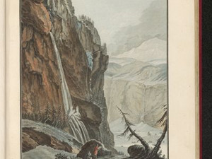
Caspar Wolf was the first artist to take the arduous path up to Alp Stufenstein (1550 m) above Stechelberg to draw the impressive view of the then still huge Breitlouwen Glacier, the Schmadribach Falls and the Breithorn. Others, such as Gabriel Matthias Lory fils, followed in his footsteps much later.


Ort auf moderner Karte
GEOMETRYCOLLECTION (POINT (7.920054 46.534452), LINESTRING (7.920054 46.534452, 7.919978 46.534367))
Camera Settings (3D)
{"landscape":{"viewpoint":{"bounds":[[-58.383212179408744,2.836732612113849],[33.278139975278634,46.53977845811315]],"bearing":-166.57999794174395,"pitch":79.05117700588302,"zoom":14.780183730188998,"center":{"lng":7.919082641600085,"lat":46.52423523069584},"cam":{"center":{"lng":7.118454524276217,"lat":28.679378804916723},"zoom":3.363780389664576,"bearing":0},"cameraToCenterDistance":1107.646491440297,"cameraPosition":{"lngLat":{"lng":7.925389725349419,"lat":46.54241964662452},"altitude":2388.398781727747},"cameraTargetElevation":1986.184387342159},"camera.fov":60,"image.scale":432},"portrait":{"image.scale":333,"viewpoint":{"bounds":[[-66.82460968580367,-3.5060586518484342],[36.50297785580372,46.54041331021017]],"bearing":-166.57999794174395,"pitch":79.05117700588302,"zoom":14.607343793839167,"center":{"lng":7.9163360595703125,"lat":46.52289169902295},"cameraToCenterDistance":1107.646491440297,"cameraPosition":{"lngLat":{"lng":7.923445879527037,"lat":46.543390612848185},"altitude":2388.39257993979},"cameraTargetElevation":1934.9750000010017}},"square":{"image.scale":329,"viewpoint":{"bounds":[[-66.82460274197038,-3.506053437335879],[36.50297520026035,46.5404133102094]],"bearing":-166.57999794174395,"pitch":79.05117700588302,"zoom":14.607343793839167,"center":{"lng":7.91633605957054,"lat":46.52289169902207},"cam":{"center":{"lng":449.8132869691833,"lat":60.4012007874245},"zoom":-1.1992284517190925,"bearing":0},"cameraToCenterDistance":1107.646491440297,"cameraPosition":{"lngLat":{"lng":7.923445879527321,"lat":46.543390612847304},"altitude":2388.392579939797},"cameraTargetElevation":1934.9750000010017}}}
Ort
GEOMETRYCOLLECTION (POINT (7.872736 46.506), LINESTRING (7.872736 46.506, 7.880419 46.499626))
Titel
View from Oberhoresee to the Gross- and Breithorn
Text

Just below the Breithorn glacier, the small Oberhoresee lake has formed at 2065 m. From here, there was an overwhelming view of the glaciers below the Grosshorn and Breithorn. The small lake still exists today.

Aufnahmestandort
nb-482054
Ort auf moderner Karte
GEOMETRYCOLLECTION (POINT (7.85538 46.512819), LINESTRING (7.85538 46.512819, 7.855455 46.512734))
Camera Settings (3D)
{"landscape":{"camera.fov":60,"viewpoint":{"bounds":[[7.225413111557174,45.06413701514725],[9.502648282635164,46.51727636824265]],"bearing":143.34643054892868,"pitch":75.09558219222602,"zoom":13.86320541281351,"center":{"lng":7.880501747131348,"lat":46.49109493276748},"cam":{"center":{"lng":8.885528649651661,"lat":45.8358283230196},"zoom":8.60104460404441,"bearing":0},"cameraToCenterDistance":1107.646491440297,"cameraPosition":{"lngLat":{"lng":7.850351795885729,"lat":46.518982922645364},"altitude":3455.0332739342916},"cameraTargetElevation":2425.9625000007045},"image.scale":355},"portrait":{"image.scale":273,"viewpoint":{"bounds":[[7.233968403989223,45.08431782064176],[9.47877815784554,46.51651974621066]],"bearing":143.34643054892868,"pitch":75.09558219222602,"zoom":13.883895517227959,"center":{"lng":7.879729270935059,"lat":46.49071083586202},"cameraToCenterDistance":1107.646491440297,"cameraPosition":{"lngLat":{"lng":7.850008623069954,"lat":46.51820202488611},"altitude":3455.050059659355},"cameraTargetElevation":2440.625000000771}},"square":{"image.scale":194,"viewpoint":{"bounds":[[7.225413111614529,45.06413701514245],[9.502648282691183,46.5172763682414]],"bearing":143.34643054892868,"pitch":75.09558219222602,"zoom":13.86320541281351,"center":{"lng":7.880501747132826,"lat":46.49109493276612},"cam":{"center":{"lng":18.611588966997886,"lat":46.58365949880684},"zoom":4.304569809410841,"bearing":0},"cameraToCenterDistance":1107.646491440297,"cameraPosition":{"lngLat":{"lng":7.850351795887292,"lat":46.518982922644},"altitude":3455.0332739343175},"cameraTargetElevation":2425.9625000007045}}}
Bilder
nb-482088
Ort
GEOMETRYCOLLECTION (POINT (7.878049 46.504267), LINESTRING (7.878049 46.504267, 7.852125 46.482016))
Titel
View of the Breithorn glacier
Text

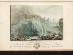
The view from the opposite side of the Oberhoresee reveals the full mighty splendor of the Breithorn glacier. In the late 18th century, it must have reached almost as far as the lake shore; today it would be impossible to capture the glacier and lake in one picture. The glacier was also used in those days: Miners in search of lead deposits would have hiked over the glacier into the Lötschental valley.


Aufnahmestandort
nb-482088
Ort auf moderner Karte
GEOMETRYCOLLECTION (POINT (7.885303 46.526015), LINESTRING (7.885303 46.526015, 7.885222 46.525864))
Camera Settings (3D)
{"landscape":{"camera.fov":60,"viewpoint":{"bounds":[[7.059518775392803,46.08057502800901],[8.098284855182612,46.5259232184014]],"bearing":-159.2906454116909,"pitch":74.00871732027629,"zoom":14.865176652133481,"center":{"lng":7.877272367476365,"lat":46.51098301285677},"cam":{"center":{"lng":7.801826279504894,"lat":46.32081087499077},"zoom":9.827151242871452,"bearing":0},"cameraToCenterDistance":1150.0817362257346,"cameraPosition":{"lngLat":{"lng":7.886483305828705,"lat":46.52774811615299},"altitude":2239.564662263229},"cameraTargetElevation":1668.3296877495766},"image.scale":137},"portrait":{"viewpoint":{"bounds":[[7.677498657050194,46.41516129583931],[7.934929846245581,46.52692178580827]],"bearing":-157.69064541169087,"pitch":76.0087173202763,"zoom":17.326932194857303,"center":{"lng":7.884216606616974,"lat":46.52416694760905},"cameraToCenterDistance":1150.0817362257346,"cameraPosition":{"lngLat":{"lng":7.886028321973839,"lat":46.52720484816925},"altitude":2176.296063605326},"cameraTargetElevation":2085.315283203157}},"square":{"image.scale":118,"viewpoint":{"bounds":[[7.622922781457731,46.38602334671063],[7.948098260069713,46.52723150162811]],"bearing":-157.69064541169087,"pitch":76.0087173202763,"zoom":16.989900579193613,"center":{"lng":7.884039580821877,"lat":46.52375171076113},"cam":{"center":{"lng":8.363600260518353,"lat":46.500904962201474},"zoom":8.452412725799192,"bearing":0},"cameraToCenterDistance":1150.0817362257346,"cameraPosition":{"lngLat":{"lng":7.886328058029619,"lat":46.52758905096451},"altitude":2212.8475778125003},"cameraTargetElevation":2097.9238769507137}},"null":{"camera.fov":60,"image.scale":46,"viewpoint":{"bounds":[[7.694055667378393,46.42373402153899],[7.93058721974478,46.526462518689385]],"bearing":-157.59999999999988,"pitch":76.33409683897688,"zoom":17.556209437150997,"center":{"lng":7.884256839749696,"lat":46.52410789189767},"cam":{"center":{"lng":7.863082313219962,"lat":46.47900653431566},"zoom":11.96191750124683,"bearing":0},"cameraToCenterDistance":1150.0817362257346,"cameraPosition":{"lngLat":{"lng":7.8858104728635965,"lat":46.526701360613515},"altitude":2159.027335997001},"cameraTargetElevation":2083.1851563923233}}}
Quellen

Jakob Samuel Wyttenbach, Vues remarquables des montagnes de la Suisse, Amsterdam 1785, p. 9

Bilder
nb-482057
Ort
GEOMETRYCOLLECTION (POINT (8.040318 46.616785), LINESTRING (8.040318 46.616785, 8.04224 46.614914))
Titel
At the base of the lower Grindelwald glacier
Text

"In order to get a clear idea of the lower glacier, you first go to the place where the Lütschinen flows out from under its icy load [...]. Once you have seen the outflow of the glacier and its terrifying ice towers close by, you climb up the Mettenberg to see the whole ice valley at once, so to speak, where you can get quite far up without danger, but not without difficulty."


Ort auf moderner Karte
GEOMETRYCOLLECTION (POINT (8.045511 46.613364), LINESTRING (8.045511 46.613364, 8.045962 46.613297))
Camera Settings (3D)
{"landscape":{"camera.fov":60,"viewpoint":{"bounds":[[8.024366236085939,46.605182843662476],[8.044103593010703,46.63159452617754]],"bearing":98.14663330109465,"pitch":85,"zoom":17.93442970945275,"center":{"lng":8.046715557570906,"lat":46.61335075292783},"cam":{"center":{"lng":8.048986155605377,"lat":46.619516056130294},"zoom":13.744797950595881,"bearing":0},"cameraToCenterDistance":1107.646491440297,"cameraPosition":{"lngLat":{"lng":8.043649560304118,"lat":46.61365224206179},"altitude":1048.9756785692234},"cameraTargetElevation":1028.2781249739119},"image.scale":61},"portrait":{"image.scale":50,"viewpoint":{"bounds":[[8.022878657010779,46.604613268437646],[8.043858677469302,46.63268769397561]],"bearing":98.14663330109465,"pitch":85,"zoom":17.846342408186846,"center":{"lng":8.046635091304779,"lat":46.613295479156506},"cameraToCenterDistance":1107.646491440297,"cameraPosition":{"lngLat":{"lng":8.043376058865647,"lat":46.61361595031565},"altitude":1048.9756939193428},"cameraTargetElevation":1026.975000000465}},"square":{"image.scale":74,"viewpoint":{"bounds":[[8.024356185404969,46.60517844930405],[8.044103697880303,46.63160384482646]],"bearing":98.14663330146392,"pitch":84.99859643737095,"zoom":17.934426617059763,"center":{"lng":8.046715557565221,"lat":46.613350752928795},"cam":{"center":{"lng":8.123093747781638,"lat":46.625174165691675},"zoom":11.154038352587431,"bearing":0},"cameraToCenterDistance":1107.646491440297,"cameraPosition":{"lngLat":{"lng":8.04364956029849,"lat":46.61365224206273},"altitude":1047.6783932732346},"cameraTargetElevation":1026.975000000465}},"null":{"camera.fov":60}}
Quellen

Jakob Samuel Wyttenbach, Kurze Anleitung für diejenigen, welche eine Reise durch einen Theil der merkwürdigsten Alpgegenden des Lauterbrunnenthals, Grindelwald, und über Meyringen auf Bern zurück, machen wollen, Bern 1777, p. 13; https://doi.org/10.3931/e-rara-32756 [03.11.2023]

Bilder
nb-482061
Ort
GEOMETRYCOLLECTION (POINT (8.044696 46.625303), LINESTRING (8.044696 46.625303, 8.041293 46.599078))
Titel
View of the Lower Grindelwald Glacier
Text

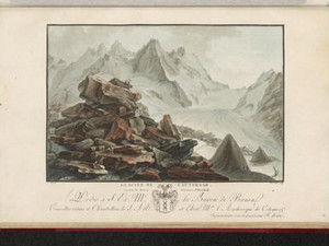
Between the Mättenberg on the left and the Eiger on the right, the lower Grindelwald glacier advanced as far as the Grindelwald valley in the 18th and 19th centuries. However, it seems that it did not always reach that far down. Jakob Samuel Wyttenbach writes that his valley with the glacier gorge used to be open and was used as a pass into Valais. The bell of the Petronilla Chapel, which once stood at the entrance to the glacier gorge, still bears witness to this. Today it rings in the church tower in Grindelwald.


Ort auf moderner Karte
GEOMETRYCOLLECTION (POINT (8.043757 46.626273), LINESTRING (8.043757 46.626273, 8.043768 46.626196))
Camera Settings (3D)
{"landscape":{"camera.fov":60,"viewpoint":{"bounds":[[7.248726131469567,46.63046575883217],[9.11817635384935,47.280309184543796]],"bearing":174.804141140125,"pitch":80.97403047091412,"zoom":14.839145084245956,"center":{"lng":8.046455383300781,"lat":46.61671129234409},"cam":{"center":{"lng":8.584644733006229,"lat":46.986791577533666},"zoom":8.979407995285046,"bearing":0},"cameraToCenterDistance":1107.646491440297,"cameraPosition":{"lngLat":{"lng":8.04407890455147,"lat":46.63465914521376},"altitude":1342.6154855409172},"cameraTargetElevation":1024.2375},"image.scale":401},"portrait":{"image.scale":257,"viewpoint":{"bounds":[[7.24872613015819,46.6304657588322],[9.118176355543937,47.28030918558022]],"bearing":174.804141140125,"pitch":80.97403047091412,"zoom":14.839145084245956,"center":{"lng":8.046455383300895,"lat":46.61671129234409},"cameraToCenterDistance":1107.646491440297,"cameraPosition":{"lngLat":{"lng":8.044078904551583,"lat":46.63465914521376},"altitude":1342.6154855409172},"cameraTargetElevation":1024.2375},"camera.fov":60},"square":{"camera.fov":60,"viewpoint":{"bounds":[[7.242307354630839,46.63046168686935],[9.126839203186108,47.285503681560016]],"bearing":174.80414114022767,"pitch":80.96161684847765,"zoom":14.839095397709515,"center":{"lng":8.046455383300554,"lat":46.616711292344604},"cam":{"center":{"lng":16.664966597407158,"lat":47.59823919317088},"zoom":4.577646919600433,"bearing":0},"cameraToCenterDistance":1107.646491440297,"cameraPosition":{"lngLat":{"lng":8.044078904551185,"lat":46.63465914521427},"altitude":1321.6626556499202},"cameraTargetElevation":1002.8394531250016},"image.scale":317}}
Quellen

Jakob Samuel Wyttenbach, Kurze Anleitung für diejenigen, welche eine Reise durch einen Theil der merkwürdigsten Alpgegenden des Lauterbrunnenthals, Grindelwald, und über Meyringen auf Bern zurück, machen wollen, Bern 1777, p. 13

Bilder
nb-482062
Ort
POINT (8.045378 46.625513)
Titel
View of the Upper Grindelwald Glacier with the Wetterhorn
Text

Like the second part of a panorama, the view of the upper Grindelwald glacier follows on from the previous one. The church serves as the focal point.

Aufnahmestandort
nb-482062
Ort auf moderner Karte
GEOMETRYCOLLECTION (POINT (8.043752 46.626185), LINESTRING (8.043752 46.626185, 8.04387 46.62617))
Camera Settings (3D)
{"landscape":{"camera.fov":86,"viewpoint":{"bounds":[[8.004885315306552,46.597731461009175],[8.042135765909677,46.67634914615252]],"bearing":94.2320982904331,"pitch":85,"zoom":15.358030277165748,"center":{"lng":8.052892684936523,"lat":46.62570118387063},"cam":{"center":{"lng":8.050990534901928,"lat":46.63915101226556},"zoom":12.847252582965755,"bearing":0},"cameraToCenterDistance":712.0528234563894,"cameraPosition":{"lngLat":{"lng":8.041049312712062,"lat":46.626303054098884},"altitude":1123.1109978152588},"cameraTargetElevation":1043.768749999343},"image.scale":79},"portrait":{"image.scale":87,"viewpoint":{"bounds":[[8.004885315263778,46.59773146096606],[8.042135765916044,46.6763491462288]],"bearing":94.2320982904331,"pitch":85,"zoom":15.358030277165748,"center":{"lng":8.052892684943004,"lat":46.625701183868955},"cameraToCenterDistance":712.0528234563894,"cameraPosition":{"lngLat":{"lng":8.041049312718513,"lat":46.62630305409721},"altitude":1123.1109978152613},"cameraTargetElevation":1043.768749999343}},"square":{"image.scale":89,"viewpoint":{"bounds":[[8.004885315254313,46.59773146095881],[8.042135765915873,46.67634914623105]],"bearing":94.2320982904331,"pitch":85,"zoom":15.358030277165748,"center":{"lng":8.052892684942663,"lat":46.6257011838685},"cam":{"center":{"lng":8.08973356398343,"lat":46.642106554902256},"zoom":11.578301409366441,"bearing":0},"cameraToCenterDistance":712.0528234563894,"cameraPosition":{"lngLat":{"lng":8.041049312718258,"lat":46.62630305409678},"altitude":1123.110997815262},"cameraTargetElevation":1043.768749999343}}}
Ort
GEOMETRYCOLLECTION (POINT (8.044229 46.655636), LINESTRING (8.044229 46.655636, 8.041139 46.660467))
Titel
The Bachalp above Grindelwald
Text

The Bachalp is on the route from Grindelwald via Scheidegg to Meiringen, which is recommended in all guidebooks. The 7-hour hike was doable on foot and on horseback without any danger. The main motif of the composition is one of the Milibach waterfalls.


Aufnahmestandort
nb-482064
Ort auf moderner Karte
GEOMETRYCOLLECTION (POINT (8.044921 46.65676), LINESTRING (8.044921 46.65676, 8.043387 46.658707))
Camera Settings (3D)
{"landscape":{"image.scale":49,"viewpoint":{"bounds":[[8.037883302802669,46.641439697356276],[8.062399211739177,46.65575062055851]],"bearing":-31.957360690293573,"pitch":85,"zoom":18.361332756968597,"center":{"lng":8.044925183057785,"lat":46.65675639895548},"cam":{"center":{"lng":8.058138541612948,"lat":46.649205618133095},"zoom":14.628052198863914,"bearing":0},"cameraToCenterDistance":1107.646491440297,"cameraPosition":{"lngLat":{"lng":8.046144616418985,"lat":46.655414714597924},"altitude":1992.4847475524773},"cameraTargetElevation":1977.1010742186781},"camera.fov":60},"portrait":{"viewpoint":{"bounds":[[8.034846542318917,46.642261631593755],[8.061252361107108,46.65562344230088]],"bearing":-23.957360690293626,"pitch":85,"zoom":18.361332756968597,"center":{"lng":8.044925183052555,"lat":46.6567563989602},"cameraToCenterDistance":1107.646491440297,"cameraPosition":{"lngLat":{"lng":8.045860702185593,"lat":46.65531128394346},"altitude":1992.484747552476},"cameraTargetElevation":1977.1010742186781},"image.scale":59,"camera.fov":60},"square":{"image.scale":63,"viewpoint":{"bounds":[[8.034846542377636,46.64226163167211],[8.0612523610109,46.655623442302755]],"bearing":-23.957360690293626,"pitch":85,"zoom":18.361332756968597,"center":{"lng":8.044925183050509,"lat":46.656756398962045},"cam":{"center":{"lng":8.16687563554396,"lat":46.658005546635735},"zoom":10.734853417565734,"bearing":0},"cameraToCenterDistance":1107.646491440297,"cameraPosition":{"lngLat":{"lng":8.045860702183603,"lat":46.65531128394531},"altitude":1992.4847475524755},"cameraTargetElevation":1977.1010742186781}}}
Quellen

Johann Gottfried Ebel, Anleitung, auf die nützlichste und genussvollste Art die Schweitz zu bereisen, vol. 3, Zurich 1810, p. 176

Bilder
nb-482071
Ort
GEOMETRYCOLLECTION (POINT (8.167028 46.673633), LINESTRING (8.167028 46.673633, 8.157189 46.64267))
Titel
The Rosenlaui Glacier
Text

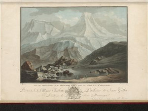
On the way from Grindelwald via Grosse Scheidegg to Haslital lies Alp Rosenlaui, where there was already a spa with sulphurous spring water in Caspar Wolf's time. Spa guests were accommodated in a simple inn, which was rebuilt as a hotel in 1862 and extended in 1904. Not far from here, you could admire the Rosenlaui Glacier, which reached down into the valley. At that time, the glacier was divided into two tongues by the Gletscherhubel. Here we can see the eastern one, with the Gletscherhubel cut off at the right-hand edge of the picture.


Ort auf moderner Karte
GEOMETRYCOLLECTION (POINT (8.165665 46.674376), LINESTRING (8.165665 46.674376, 8.165427 46.673377))
Camera Settings (3D)
{"landscape":{"camera.fov":60,"viewpoint":{"bounds":[[8.143098960081147,46.675127394231794],[8.179113518567362,46.69423132725615]],"bearing":153.36273083753963,"pitch":85,"zoom":17.881707753051028,"center":{"lng":8.166452050210864,"lat":46.673604272018025},"cam":{"center":{"lng":8.171789100463542,"lat":46.685494485834994},"zoom":14.21033619870104,"bearing":0},"cameraToCenterDistance":1107.646491440297,"cameraPosition":{"lngLat":{"lng":8.165011741404413,"lat":46.675574569484525},"altitude":1695.96804376597},"cameraTargetElevation":1674.5240234450255}},"portrait":{"camera.fov":60,"viewpoint":{"bounds":[[8.143408418955033,46.67497903873806],[8.177322271751933,46.69375505541518]],"bearing":150.96273083754,"pitch":85,"zoom":17.93649517382804,"center":{"lng":8.166355490683713,"lat":46.67356378304959},"cameraToCenterDistance":1107.646491440297,"cameraPosition":{"lngLat":{"lng":8.164854301760613,"lat":46.67541915769411},"altitude":1695.9680964072409},"cameraTargetElevation":1675.3231443610466}},"square":{"viewpoint":{"bounds":[[8.14340841895472,46.67497903873951],[8.177322271752416,46.693755055418194]],"bearing":150.96273083754,"pitch":85,"zoom":17.93649517382804,"center":{"lng":8.166355490682804,"lat":46.67356378305104},"cam":{"center":{"lng":8.312977682943227,"lat":46.69599934822918},"zoom":10.373834594445734,"bearing":0},"cameraToCenterDistance":1107.646491440297,"cameraPosition":{"lngLat":{"lng":8.164854301759704,"lat":46.675419157695586},"altitude":1695.9680964072402},"cameraTargetElevation":1675.3231443610466}}}
Quellen

Johann Gottfried Ebel, Anleitung, auf die nützlichste und genussvollste Art die Schweitz zu bereisen, vol. 3, Zurich 1810, p. 176; https://ourheritage.ch/poi/hotel-rosenlaui [08.12.2023]; Page "Rosenlauigletscher". In: Wikipedia - The free encyclopedia. Date modified: November 17, 2022, 14:04 UTC. [08.12.2023]

Bilder
nb-482082
Ort
GEOMETRYCOLLECTION (POINT (8.19564 46.726985), LINESTRING (8.19564 46.726985, 8.179514 46.69982))
Titel
At the Restiturm in Meiringen with a view of the Rosenlaui valley
Text

The Resti Tower near Meiringen is the remains of a medieval castle complex built by the knight Peter von Resti around 1250. Around 1400, the tower was fitted with a wooden battlements and oriels, which can no longer be seen in this depiction. This was in connection with the expansion of the pass road over the Grimsel and Gries Pass.
In the background, the view opens up into the Reichenbach Valley with the imposing Reichenbach Falls and the Rosenlaui Glacier with the Wellhorn and Wetterhorn.


Ort auf moderner Karte
GEOMETRYCOLLECTION (POINT (8.196176 46.726926), LINESTRING (8.196176 46.726926, 8.195629 46.726158))
Camera Settings (3D)
{"landscape":{"camera.fov":60,"viewpoint":{"bounds":[[7.4633854429550865,46.33683234362607],[8.2513035606149,46.72799358643573]],"bearing":-145.2066736702743,"pitch":77.67701252302258,"zoom":16.651603601082826,"center":{"lng":8.19279670715332,"lat":46.72370819775372},"cam":{"center":{"lng":8.075468009214859,"lat":46.549435437229675},"zoom":9.858560933341327,"bearing":0},"cameraToCenterDistance":1107.646491440297,"cameraPosition":{"lngLat":{"lng":8.197013902859567,"lat":46.72786861761901},"altitude":725.1797876501996},"cameraTargetElevation":602.1117187484335},"image.scale":62},"portrait":{"image.scale":252,"viewpoint":{"bounds":[[7.304695641625358,46.25170024653036],[8.245955695210455,46.73235219857469]],"bearing":-143.60667366808536,"pitch":75.68039689611196,"zoom":15.313736146355799,"center":{"lng":8.1903183460239,"lat":46.72149803474025},"cameraToCenterDistance":1107.646491440297,"cameraPosition":{"lngLat":{"lng":8.201311579695698,"lat":46.7317216277072},"altitude":962.6399008251931},"cameraTargetElevation":602.1117187484335}},"square":{"viewpoint":{"bounds":[[7.304695641693144,46.251700246545425],[8.245955695249222,46.73235219857483]],"bearing":-143.60667366808536,"pitch":75.68039689611196,"zoom":15.313736146355799,"center":{"lng":8.190318346023219,"lat":46.72149803474039},"cam":{"center":{"lng":12.010995909473621,"lat":46.81559695146518},"zoom":5.5791878219896445,"bearing":0},"cameraToCenterDistance":1107.646491440297,"cameraPosition":{"lngLat":{"lng":8.201311579694988,"lat":46.731721627707344},"altitude":962.6399008251922},"cameraTargetElevation":602.1117187484335},"image.scale":359}}
Quellen

Daniel Gutscher, "Restiturm", in: Historisches Lexikon der Schweiz (HLS), version of 23.12.2011 [01.12.2023]

Ort
GEOMETRYCOLLECTION (POINT (8.224423 46.708056), LINESTRING (8.224423 46.708056, 8.22644 46.706643))
Titel
In the Haslital near Innertkirchen
Text

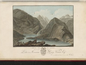
Although it is not certain where the bridge shown in the view is located, we can see an important traffic junction here. On the left, the Gadmental leads to the Susten Pass, on the right it goes along the Aare to the Grimsel.

Aufnahmestandort
nb-482065
Ort auf moderner Karte
GEOMETRYCOLLECTION (POINT (8.224564 46.707624), LINESTRING (8.224564 46.707624, 8.224694 46.707585))
Camera Settings (3D)
{"landscape":{"camera.fov":60,"image.scale":87,"viewpoint":{"bounds":[[8.114299354155293,46.68060276952289],[8.2232003000276,46.80530605599742]],"bearing":109.76032011106803,"pitch":85,"zoom":15.618927107913375,"center":{"lng":8.235186338420021,"lat":46.705005374972416},"cam":{"center":{"lng":8.238558910209093,"lat":46.7483055645429},"zoom":11.50221952451806,"bearing":0},"cameraToCenterDistance":1107.646491440297,"cameraPosition":{"lngLat":{"lng":8.220676748444134,"lat":46.7085797024036},"altitude":735.2287723885037},"cameraTargetElevation":632.3753906250274}},"portrait":{"image.scale":98,"viewpoint":{"bounds":[[8.114299353734907,46.680602769399115],[8.22320030003499,46.80530605639393]],"bearing":109.76032011106803,"pitch":85,"zoom":15.618927107913375,"center":{"lng":8.235186338428093,"lat":46.70500537497031},"cameraToCenterDistance":1107.646491440297,"cameraPosition":{"lngLat":{"lng":8.220676748452263,"lat":46.70857970240144},"altitude":735.2287723885078},"cameraTargetElevation":632.3753906250274}},"square":{"image.scale":101,"viewpoint":{"bounds":[[8.114299353727517,46.680602769409774],[8.223200300029646,46.80530605640192]],"bearing":109.76032011106803,"pitch":85,"zoom":15.618927107913375,"center":{"lng":8.23518633842275,"lat":46.70500537497193},"cam":{"center":{"lng":8.658804085238074,"lat":46.78029094672519},"zoom":8.69076470071198,"bearing":0},"cameraToCenterDistance":1107.646491440297,"cameraPosition":{"lngLat":{"lng":8.220676748446976,"lat":46.708579702403114},"altitude":735.2287723885046},"cameraTargetElevation":632.3753906250274}}}
Bilder
nb-482081
Ort
GEOMETRYCOLLECTION (POINT (8.253522 46.710942), LINESTRING (8.253522 46.710942, 8.264135 46.711942))
Titel
The Mühletal weir near Innertkirchen
Text

This view can only be localized imprecisely. What is certain is that it shows a section of the Sustenpass road in the Gadmertal valley. However, it is uncertain whether the footbridge depicted leads over the Gadmerwasser or the Gantelwasser, which flows into Mühletal. Or does the "Tritt" refer to the Triftwasser? In any case, the name of the view bears witness to the constantly changing names of fields and waters.


Ort auf moderner Karte
GEOMETRYCOLLECTION (POINT (8.253076 46.710581), LINESTRING (8.253076 46.710581, 8.254842 46.710804))
Camera Settings (3D)
{"landscape":{"image.scale":75,"viewpoint":{"bounds":[[8.04367486839078,46.592527873816266],[8.250182982957824,46.85575160338999]],"bearing":82.16858989977639,"pitch":80.52731428454476,"zoom":17.576475742748716,"center":{"lng":8.253075999999055,"lat":46.71058100000073},"cam":{"center":{"lng":8.294230884662255,"lat":46.73551877206256},"zoom":10.424929575568717,"bearing":0},"cameraToCenterDistance":1107.646491440297,"cameraPosition":{"lngLat":{"lng":8.249182366744662,"lat":46.710213790210446},"altitude":830.4703926178421},"cameraTargetElevation":780.4707327946803}},"portrait":{"image.scale":85,"viewpoint":{"bounds":[[8.043674865955495,46.592527872016376],[8.250182982958705,46.85575160516831]],"bearing":82.16858989977639,"pitch":80.52731428454476,"zoom":17.576475742748716,"center":{"lng":8.253076000000192,"lat":46.710581000000474},"cameraToCenterDistance":1107.646491440297,"cameraPosition":{"lngLat":{"lng":8.249182366745913,"lat":46.71021379021016},"altitude":830.4703926178423},"cameraTargetElevation":780.4707327946803}},"square":{"image.scale":96,"viewpoint":{"bounds":[[8.043674865925368,46.592527871959305],[8.250182982957995,46.85575160511155]],"bearing":82.16858989977639,"pitch":80.52731428454476,"zoom":17.576475742748716,"center":{"lng":8.253075999999169,"lat":46.71058099999942},"cam":{"center":{"lng":9.07621545108853,"lat":46.79503550060977},"zoom":7.76758270171482,"bearing":0},"cameraToCenterDistance":1107.646491440297,"cameraPosition":{"lngLat":{"lng":8.249182366744833,"lat":46.71021379020908},"altitude":830.4703926178433},"cameraTargetElevation":780.4707327946803}}}
Bilder
nb-482066
Ort
GEOMETRYCOLLECTION (POINT (8.303733 46.629459), LINESTRING (8.303733 46.629459, 8.304595 46.622741))
Titel
A bridge over the Aare on the way to the Grimsel Pass
Text

The Schwarzbrunnenbrigg allowed people to cross the Aare on a mule track about two or three meters wide. It was replaced in 1893 by the bridge that still exists today. However, the road over the Grimsel built shortly afterwards bypasses it.


Ort auf moderner Karte
GEOMETRYCOLLECTION (POINT (8.30384 46.628932), LINESTRING (8.30384 46.628932, 8.303862 46.628016))
Camera Settings (3D)
{"landscape":{"viewpoint":{"bounds":[[8.288590099164793,46.63081944840755],[8.32789266280571,46.64327043525441]],"bearing":179.58979698182088,"pitch":85,"zoom":17.91750228402262,"center":{"lng":8.303850889205364,"lat":46.62895228321065},"cam":{"center":{"lng":8.316675910291224,"lat":46.63768877347766},"zoom":14.551254822151643,"bearing":0},"cameraToCenterDistance":1107.646491440297,"cameraPosition":{"lngLat":{"lng":8.303828453237116,"lat":46.631104234386044},"altitude":1230.0254470600323},"cameraTargetElevation":1209.0896484358896},"image.scale":84},"portrait":{"image.scale":95,"viewpoint":{"bounds":[[8.288590099099991,46.630819448406555],[8.327892662904986,46.64327043530727]],"bearing":179.58979698182088,"pitch":85,"zoom":17.91750228402262,"center":{"lng":8.303850889205705,"lat":46.62895228320966},"cameraToCenterDistance":1107.646491440297,"cameraPosition":{"lngLat":{"lng":8.303828453237486,"lat":46.63110423438502},"altitude":1230.0254470600328},"cameraTargetElevation":1209.0896484358896}},"square":{"image.scale":87,"viewpoint":{"bounds":[[8.28859009910883,46.6308194484092],[8.3278926628916,46.64327043530005]],"bearing":179.58979698182088,"pitch":85,"zoom":17.91750228402262,"center":{"lng":8.303850889205933,"lat":46.62895228321224},"cam":{"center":{"lng":8.485102918022648,"lat":46.65053653357916},"zoom":10.161085860744254,"bearing":0},"cameraToCenterDistance":1107.646491440297,"cameraPosition":{"lngLat":{"lng":8.303828453237742,"lat":46.63110423438758},"altitude":1230.0254470600319},"cameraTargetElevation":1209.0896484358896}}}
Bilder
nb-482060
Ort
GEOMETRYCOLLECTION (POINT (8.307724 46.614456), LINESTRING (8.307724 46.614456, 8.308662 46.612734))
Titel
The fall of the Aare above Guttannen (Handeggfall)
Text

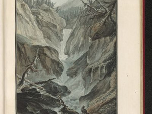
This view was drawn by Caspar Wolf on a trip to the Grimsel Pass. The path to this viewpoint was not without its dangers, as it led through precipices and you had to climb from rock to rock. We often don't think about the efforts and dangers artists went to in order to draw spectacular views. The text for this view at Handegg Waterfall strongly advises inexperienced travelers not to go to this place and even reports that the artist had to make several attempts to get there.


Ort auf moderner Karte
GEOMETRYCOLLECTION (POINT (8.30804 46.613685), LINESTRING (8.30804 46.613685, 8.308174 46.613283))
Camera Settings (3D)
{"landscape":{"image.scale":50,"viewpoint":{"bounds":[[8.248653936393225,46.61524984560515],[8.346622396217015,46.67915369115528]],"bearing":164.58446959286562,"pitch":85,"zoom":18.695385039785286,"center":{"lng":8.30803245306015,"lat":46.61369529150963},"cam":{"center":{"lng":8.320930383638654,"lat":46.64898782507862},"zoom":13.085786302192341,"bearing":0},"cameraToCenterDistance":1918.5,"cameraPosition":{"lngLat":{"lng":8.307190960364778,"lat":46.61579156677706},"altitude":1420.0437444576783},"cameraTargetElevation":1398.889062500244}},"portrait":{"image.scale":50,"viewpoint":{"bounds":[[8.248653936380606,46.615249845603245],[8.34662239627363,46.6791536911939]],"bearing":164.58446959286562,"pitch":85,"zoom":18.695385039785286,"center":{"lng":8.30803245306106,"lat":46.61369529150795},"cameraToCenterDistance":1918.5,"cameraPosition":{"lngLat":{"lng":8.30719096036566,"lat":46.615791566775414},"altitude":1420.043744457679},"cameraTargetElevation":1398.889062500244}},"square":{"image.scale":50,"viewpoint":{"bounds":[[8.248653935086026,46.61524984560003],[8.346622397095132,46.679153692563204]],"bearing":164.58446959286562,"pitch":85,"zoom":18.695385039785286,"center":{"lng":8.308032453062651,"lat":46.61369529150417},"cam":{"center":{"lng":8.738496245131586,"lat":46.680827869368784},"zoom":8.84339189428374,"bearing":0},"cameraToCenterDistance":1918.5,"cameraPosition":{"lngLat":{"lng":8.307190960367308,"lat":46.615791566771605},"altitude":1420.0437444576805},"cameraTargetElevation":1398.889062500244}}}
Quellen

Jakob Samuel Wyttenbach, Vues remarquables des montagnes de la Suisse, Amsterdam 1785, p. 12

Bilder
nb-482063
Ort
GEOMETRYCOLLECTION (POINT (8.339816 46.570777), LINESTRING (8.339816 46.570777, 8.324369 46.569715))
Titel
View of the Grimsel Hospice on the Grimsel Pass
Text

The Grimsel Pass connects the Bernese Oberland with the Valais and the upper Italian valleys. "The hospice is situated in a terrifyingly dreadful rocky region. The Spithalmeister, an inhabitant of Hasli, [...] has permission to take up a collection in the Schweitz; in return, he must feed and shelter the poor hikers." We also learn that the hospice was occupied from March to November, had 7 regular beds and sometimes accommodated 96 people. Up to 300 packhorses crossed the pass every week.

Aufnahmestandort
nb-482063
Ort auf moderner Karte
GEOMETRYCOLLECTION (POINT (8.339289 46.570573), LINESTRING (8.339289 46.570573, 8.3391 46.570582))
Camera Settings (3D)
{"landscape":{"camera.fov":60,"viewpoint":{"bounds":[[8.298027654678748,46.54779232387787],[8.34067736292252,46.586464135781426]],"bearing":-114.79789400255778,"pitch":66.18354555183491,"zoom":18.352628224064134,"center":{"lng":8.339021354914166,"lat":46.57060637128774},"cam":{"center":{"lng":8.340930760434219,"lat":46.568779999773454},"zoom":13.196056311588869,"bearing":0},"cameraToCenterDistance":1107.646491440297,"cameraPosition":{"lngLat":{"lng":8.340953660550582,"lat":46.57122010775237},"altitude":1978.1315531475211},"cameraTargetElevation":1906.310760310967}},"portrait":{"viewpoint":{"bounds":[[8.298027654693726,46.5477923238908],[8.340677362921468,46.586464135774264]],"bearing":-114.79789400255778,"pitch":66.18354555183491,"zoom":18.352628224064134,"center":{"lng":8.339021354913257,"lat":46.57060637128723},"cameraToCenterDistance":1107.646491440297,"cameraPosition":{"lngLat":{"lng":8.340953660549758,"lat":46.571220107751856},"altitude":1978.1315531475218},"cameraTargetElevation":1906.310760310967}},"square":{"viewpoint":{"bounds":[[8.298027654738178,46.54779232391192],[8.340677362921184,46.58646413575627]],"bearing":-114.79789400255778,"pitch":66.18354555183491,"zoom":18.352628224064134,"center":{"lng":8.339021354912802,"lat":46.57060637128728},"cam":{"center":{"lng":8.511276195653238,"lat":46.581790621699184},"zoom":10.043173415706585,"bearing":0},"cameraToCenterDistance":1107.646491440297,"cameraPosition":{"lngLat":{"lng":8.340953660549246,"lat":46.5712201077518},"altitude":1978.1315531475218},"cameraTargetElevation":1906.310760310967}}}
Quellen

Johann Gottfried Ebel, Anleitung, auf die nützlichste und genussvollste Art die Schweitz zu bereisen, vol. 3, Zurich 1810, p. 165

Bilder
nb-482069
Ort
GEOMETRYCOLLECTION (POINT (8.229094 46.562047), LINESTRING (8.229094 46.562047, 8.204765 46.566178))
Titel
On the Unteraargletscher (Vorderaargletscher)
Text

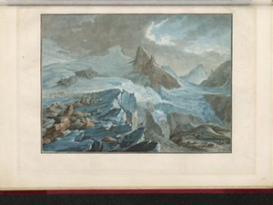
When the glacier ice melts around the boulders on top of it in summer and the ice remains directly under the rock, so-called glacier tables are formed. "On some glaciers, for example on the Aar glaciers, high, regular ice pyramids have been seen rising above the rest of the flat surface of the glacier, with a broad boulder on top of them."


Ort auf moderner Karte
GEOMETRYCOLLECTION (POINT (8.217595 46.562519), LINESTRING (8.217595 46.562519, 8.213975 46.563119))
Camera Settings (3D)
{"landscape":{"viewpoint":{"bounds":[[8.221820329965254,46.51721511987486],[8.278341125221175,46.5759406516423]],"bearing":-75.77773220038267,"pitch":85,"zoom":17.380112365519448,"center":{"lng":8.217387199396399,"lat":46.562539579095784},"cam":{"center":{"lng":8.282836229064088,"lat":46.549088888714266},"zoom":12.593897051792508,"bearing":0},"cameraToCenterDistance":1371.4121756658628,"cameraPosition":{"lngLat":{"lng":8.222845911676018,"lat":46.56158831158322},"altitude":2209.976206817118},"cameraTargetElevation":2172.309375000162},"image.scale":98,"camera.fov":50},"portrait":{"image.scale":101,"viewpoint":{"bounds":[[8.221820329970257,46.51721511985781],[8.278341125256759,46.575940651631726]],"bearing":-75.77773220038267,"pitch":85,"zoom":17.380112365519448,"center":{"lng":8.217387199401855,"lat":46.56253957909425},"cameraToCenterDistance":1371.4121756658628,"cameraPosition":{"lngLat":{"lng":8.22284591168156,"lat":46.56158831158166},"altitude":2209.976206817119},"cameraTargetElevation":2172.309375000162}},"square":{"image.scale":96,"viewpoint":{"bounds":[[8.221820329963577,46.51721511949327],[8.27834112570892,46.57594065176926]],"bearing":-75.77773220038267,"pitch":85,"zoom":17.380112365519448,"center":{"lng":8.217387199394693,"lat":46.562539579095784},"cam":{"center":{"lng":8.50442430869029,"lat":46.56601884762094},"zoom":9.636927508865247,"bearing":0},"cameraToCenterDistance":1371.4121756658628,"cameraPosition":{"lngLat":{"lng":8.222845911674426,"lat":46.561588311583165},"altitude":2209.976206817118},"cameraTargetElevation":2172.309375000162}}}
Quellen

Johann Gottfried Ebel, Anleitung, auf die nützlichste und genussvollste Art die Schweitz zu bereisen, vol. 3, Zurich 1810, pp. 118-119

Bilder
nb-482067
Ort
GEOMETRYCOLLECTION (POINT (8.269801 46.559921), LINESTRING (8.269801 46.559921, 8.117383 46.591426))
Titel
View of the Lauteraar glacier
Text

"I advise anyone who is interested in nature in the highest mountains to climb the Lauteraar glacier; in the hospital [Grimselhospiz] you will find signposts and safe guides. Nearby, you can see the Finsteraar-Horn, which is the highest mountain in this entire Alpine chain and in Europe after Mont Blanc."


Aufnahmestandort
nb-482067
Ort auf moderner Karte
GEOMETRYCOLLECTION (POINT (8.192925 46.565034), LINESTRING (8.192925 46.565034, 8.186874 46.566251))
Camera Settings (3D)
{"landscape":{"viewpoint":{"bounds":[[8.194633999421853,46.55129254347793],[8.209991710090378,46.5691630948084]],"bearing":-71.21493961573259,"pitch":85,"zoom":18.435232449798878,"center":{"lng":8.192917406551032,"lat":46.56549019659789},"cam":{"center":{"lng":8.208816015587843,"lat":46.56072538809815},"zoom":14.926421278468137,"bearing":0},"cameraToCenterDistance":1107.646491440297,"cameraPosition":{"lngLat":{"lng":8.194989682712134,"lat":46.56500558731133},"altitude":2322.471679399417},"cameraTargetElevation":2307.831518393845},"image.scale":50,"camera.fov":60},"portrait":{"image.scale":101,"viewpoint":{"bounds":[[8.196057278386292,46.53464407786501],[8.229041523930817,46.58031065211745]],"bearing":-84.01493961573213,"pitch":84,"zoom":17.682120145298253,"center":{"lng":8.193003237247467,"lat":46.565160104220354},"cameraToCenterDistance":1107.646491440297,"cameraPosition":{"lngLat":{"lng":8.196666143051146,"lat":46.56489607772153},"altitude":2338.2437031320374},"cameraTargetElevation":2308.6501953124452}},"square":{"image.scale":109,"viewpoint":{"bounds":[[8.1960572783928,46.534644077980914],[8.229041523827476,46.5803106520321]],"bearing":-84.01493961573213,"pitch":84,"zoom":17.682120145298253,"center":{"lng":8.19300323725463,"lat":46.565160104219245},"cam":{"center":{"lng":8.360978505566237,"lat":46.56882140457486},"zoom":10.413932184679178,"bearing":0},"cameraToCenterDistance":1107.646491440297,"cameraPosition":{"lngLat":{"lng":8.196666143058337,"lat":46.56489607772042},"altitude":2338.243703132038},"cameraTargetElevation":2308.6501953124452}}}
Quellen

Johann Gottfried Ebel, Anleitung, auf die nützlichste und genussvollste Art die Schweitz zu bereisen, vol. 2, Zurich 1810, p. 77

Bilder
nb-482049
Ort
GEOMETRYCOLLECTION (POINT (8.320599 46.954129), LINESTRING (8.320599 46.954129, 8.385805 46.940117))
Titel
View from inside the dragon's cave in the canton of Unterwalden
Text

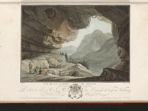
The name of this view goes back to a legend according to which this cave was once inhabited by a dragon that ravaged the valley. The creature is said to have lingered in the large hole in the vault. The inhabitants praised Arnold Winkelried for fighting the monster and freeing his homeland. This viewpoint is interesting as it was taken from inside the cave, but still shows the small village of Stans and part of Lake Lucerne.


Ort auf moderner Karte
GEOMETRYCOLLECTION (POINT (8.320405 46.954326), LINESTRING (8.320405 46.954326, 8.321414 46.954125))
Camera Settings (3D)
{"landscape":{"viewpoint":{"bounds":[[8.322404431111494,46.854171807069264],[8.460593929994332,47.024194832935564]],"bearing":89.42954669490835,"pitch":76.34056558710427,"zoom":15.518669747855187,"center":{"lng":8.336563110351562,"lat":46.95423162566985},"cam":{"center":{"lng":8.448998280182707,"lat":46.93925080753027},"zoom":11.470150915954184,"bearing":0},"cameraToCenterDistance":1403.254678080042,"cameraPosition":{"lngLat":{"lng":8.316140933659995,"lat":46.95409283206101},"altitude":927.015030553561},"cameraTargetElevation":550.2999999999075},"image.scale":92,"camera.fov":49},"portrait":{"image.scale":101,"viewpoint":{"bounds":[[8.315119263788972,46.92650156405068],[8.365639877347348,46.972973732275136]],"bearing":90.2295466949911,"pitch":79.00000000000004,"zoom":17.38973813046552,"center":{"lng":8.320182859889883,"lat":46.95418951659835},"cameraToCenterDistance":1918.5,"cameraPosition":{"lngLat":{"lng":8.312471967534549,"lat":46.95421060339882},"altitude":920.5389171851838},"cameraTargetElevation":806.7758309241652}},"square":{"image.scale":102,"viewpoint":{"bounds":[[8.314263171752572,41.25458005708657],[14.15658090630967,50.21196507844164]],"bearing":90.22954669534897,"pitch":78.99996578290272,"zoom":16.59725671261025,"center":{"lng":8.32018285988886,"lat":46.95418951659707},"cam":{"center":{"lng":37.52585184453807,"lat":47.90880887135066},"zoom":2.945312275032709,"bearing":0},"cameraToCenterDistance":1107.646491440297,"cameraPosition":{"lngLat":{"lng":8.312471967533327,"lat":46.9542106033976},"altitude":920.5392799771298},"cameraTargetElevation":806.7758309903}}}
Quellen

Jakob Samuel Wyttenbach, Vues remarquables des montagnes de la Suisse, Amsterdam 1785, p. 6

Bilder
nb-482073
Ort
GEOMETRYCOLLECTION (POINT (8.362098 47.03287), LINESTRING (8.362098 47.03287, 8.382486 47.055398))
Titel
Near Meggen: Monument in memory of the founders of Swiss freedom
Text

The former freedom monument by Abbé Guillaume-Thomas Raynal from 1783 on the old town island near Meggen is crowned by the bronze apple that William Tell shot through. The Gessler hat is depicted in oval relief on the front. The monument was one of the sights of primeval Switzerland - Johann Wolfgang Goethe also wanted to visit it on his trip to Switzerland in 1797, but arrived too late: a lightning strike destroyed it in 1796. Parts of the monument were later reused at various locations in Lucerne.


Ort auf moderner Karte
GEOMETRYCOLLECTION (POINT (8.362608 47.032468), LINESTRING (8.362608 47.032468, 8.361186 47.032601))
Camera Settings (3D)
{"landscape":{"image.scale":60,"viewpoint":{"bounds":[[8.264607026436607,47.02643471557363],[8.365518460531803,47.100538274469926]],"bearing":-67.83668918997815,"pitch":81.02730459487023,"zoom":18.360302785977765,"center":{"lng":8.3626080000098,"lat":47.03246800000025},"cam":{"center":{"lng":8.356794776874182,"lat":47.06665787008447},"zoom":12.24447907003368,"bearing":0},"cameraToCenterDistance":1918.5,"cameraPosition":{"lngLat":{"lng":8.366274982235183,"lat":47.03144988861851},"altitude":484.072382297736},"cameraTargetElevation":436.68955078130307}},"portrait":{"image.scale":60,"viewpoint":{"bounds":[[8.365331661078443,46.72107068470507],[8.836601875811198,47.07817774783831]],"bearing":-71.83668919002395,"pitch":84.02902483329706,"zoom":18.360309624633782,"center":{"lng":8.362608000023783,"lat":47.032467999996186},"cameraToCenterDistance":1918.5,"cameraPosition":{"lngLat":{"lng":8.366396174702487,"lat":47.03162092018911},"altitude":497.7032322685189},"cameraTargetElevation":466.0999999999807}},"square":{"image.scale":56,"viewpoint":{"bounds":[[8.365331661073725,46.72107066076339],[8.836601911996127,47.07817775150113]],"bearing":-71.83668919002395,"pitch":84.02902483329706,"zoom":18.360309624633782,"center":{"lng":8.362608000018213,"lat":47.03246799999664},"cam":{"center":{"lng":10.721682915685847,"lat":47.06068334545529},"zoom":6.577226577551647,"bearing":0},"cameraToCenterDistance":1918.5,"cameraPosition":{"lngLat":{"lng":8.366396174696945,"lat":47.03162092018951},"altitude":497.7032322685186},"cameraTargetElevation":466.0999999999807}},"null":{"viewpoint":{"bounds":[[8.364438826174023,47.00951244577121],[8.39242466730559,47.03436308609179]],"bearing":-63.836689189978244,"pitch":85,"zoom":18.57386273421914,"center":{"lng":8.362671732885246,"lat":47.03246608022749},"cam":{"center":{"lng":8.387552901327098,"lat":47.02263010266631},"zoom":14.438345925157805,"bearing":0},"cameraToCenterDistance":1403.254678080042,"cameraPosition":{"lngLat":{"lng":8.364932613840551,"lat":47.03170904403163},"altitude":453.5620166506428},"cameraTargetElevation":436.85957036754985}}}
Bilder
nb-482072
Ort
GEOMETRYCOLLECTION (POINT (8.452096 47.092455), LINESTRING (8.452096 47.092455, 8.459261 47.096195))
Titel
The Tell Chapel in the canton of Schwyz
Text

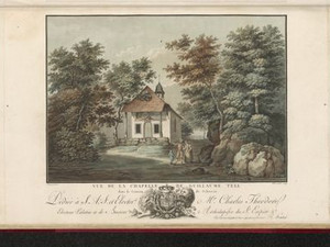
The Tell Chapel in Küssnacht is actually dedicated to the 14 holy helpers. The current building was erected in 1638, but a chapel is said to have stood on this site before that, where William Tell is said to have shot the bailiff Gessler. In 1760, the chapel was given an altarpiece by Caspar Wolf, who also painted most of the views in this series. In 1905, the connection with the Tell legend was further strengthened by the addition of murals by Hans Bachmann on the exterior and interior of the chapel.


Ort auf moderner Karte
GEOMETRYCOLLECTION (POINT (8.453016 47.092484), LINESTRING (8.453016 47.092484, 8.454474 47.093558))
Camera Settings (3D)
{"landscape":{"viewpoint":{"bounds":[[8.405168248901049,47.063946849999724],[8.452579114598677,47.09209687694752]],"bearing":39.21078200234593,"pitch":85,"zoom":19.756650199962852,"center":{"lng":8.453131914138794,"lat":47.09265776973032},"cam":{"center":{"lng":8.444730923669965,"lat":47.07922357674076},"zoom":13.640492425346856,"bearing":0},"cameraToCenterDistance":1918.5,"cameraPosition":{"lngLat":{"lng":8.452172885346016,"lat":47.09185751107054},"altitude":493.7074218729358},"cameraTargetElevation":483.65986328134335},"image.scale":19},"portrait":{"viewpoint":{"bounds":[[8.399523882515183,47.06047105280163],[8.452402706714594,47.09186875106067]],"bearing":39.21078200234593,"pitch":85,"zoom":19.599177850552536,"center":{"lng":8.453019261360396,"lat":47.092494334651946},"cameraToCenterDistance":1918.5,"cameraPosition":{"lngLat":{"lng":8.451949626504359,"lat":47.091601777586476},"altitude":494.8662545287158},"cameraTargetElevation":483.65986328134335},"image.scale":19},"square":{"viewpoint":{"bounds":[[8.399523882528115,47.06047105281053],[8.452402706712917,47.09186875106096]],"bearing":39.21078200234593,"pitch":85,"zoom":19.599177850552536,"center":{"lng":8.453019261358804,"lat":47.09249433465229},"cam":{"center":{"lng":8.663918003452181,"lat":47.09417508501002},"zoom":9.733019188714241,"bearing":0},"cameraToCenterDistance":1918.5,"cameraPosition":{"lngLat":{"lng":8.451949626502795,"lat":47.09160177758682},"altitude":494.86625452871573},"cameraTargetElevation":483.65986328134335},"image.scale":21}}
Quellen

Franz Wyrsch, "Hohle Gasse", in: Historisches Lexikon der Schweiz (HLS), version of 22.11.2006 [27.11.2023]; Désiré Raoul-Rochette, Lettres sur quelques cantons de la Suisse, écrites en 1819, Paris 1820, p. 320

Bilder
nb-482078
Ort
GEOMETRYCOLLECTION (POINT (8.598518 47.030442), LINESTRING (8.598518 47.030442, 8.593032 47.035291))
Titel
View of Lake Lauerz with the island of Schwanau
Text

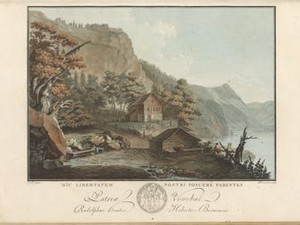
The island of Schwanau with the castle of the same name was inhabited in the 17th and 18th centuries by hermits, people who lived their lives in solitude and religious devotion. 
There is a legend that the castle was razed by the rural population around 1300 during the liberation of central Switzerland from Habsburg rule. We know that the castle only existed for about a century. It was built in the late 12th century by an unknown noble family and destroyed in the mid-13th century.
In 1806, the Goldau landslide triggered a tsunami on Lake Lauerz, which flooded the island and destroyed the church with the hermitage.


Ort auf moderner Karte
GEOMETRYCOLLECTION (POINT (8.600279 47.030422), LINESTRING (8.600279 47.030422, 8.599425 47.030897))
Camera Settings (3D)
{"landscape":{"image.scale":73,"viewpoint":{"bounds":[[8.60176760261865,46.848398406215125],[8.86920766042249,47.043541307883885]],"bearing":-68.01188847237887,"pitch":85,"zoom":17.094446961666304,"center":{"lng":8.595128059387207,"lat":47.031842677325045},"cam":{"center":{"lng":8.84514263341552,"lat":46.95437591212129},"zoom":10.850734570848788,"bearing":0},"cameraToCenterDistance":1918.5,"cameraPosition":{"lngLat":{"lng":8.60403235423263,"lat":47.02939201251968},"altitude":510.17353845670414},"cameraTargetElevation":446.5000000000018}},"portrait":{"image.scale":67,"viewpoint":{"bounds":[[8.601767602616889,46.848398406197674],[8.869207660452531,47.0435413079002]],"bearing":-68.01188847237887,"pitch":85,"zoom":17.094446961666304,"center":{"lng":8.595128059385729,"lat":47.03184267732573},"cameraToCenterDistance":1918.5,"cameraPosition":{"lngLat":{"lng":8.604032354231066,"lat":47.029392012520304},"altitude":510.17353845670334},"cameraTargetElevation":446.5000000000018}},"square":{"image.scale":72,"viewpoint":{"bounds":[[8.601767602614672,46.84839840623994],[8.8692076603962,47.043541307896135]],"bearing":-68.01188847237887,"pitch":85,"zoom":17.094446961666304,"center":{"lng":8.595128059383455,"lat":47.031842677326125},"cam":{"center":{"lng":9.938967891522452,"lat":47.03726981629998},"zoom":7.394565619448652,"bearing":0},"cameraToCenterDistance":1918.5,"cameraPosition":{"lngLat":{"lng":8.604032354228735,"lat":47.02939201252073},"altitude":510.1735384567029},"cameraTargetElevation":446.5000000000018}}}
Quellen

Erwin Horat, "Schwanau", in: Historisches Lexikon der Schweiz (HLS), version of 10.11.2011 [04.12.2023]

Bilder
nb-482058
Ort
GEOMETRYCOLLECTION (POINT (8.59221 46.969213), LINESTRING (8.59221 46.969213, 8.593016 46.974539))
Titel
On the Rütli meadow on Lake Lucerne
Text

The Rütli meadow lies at the foot of the Seelisberg on Lake Uri. At least since it was mentioned in the "White Book of Sarnen" around 1470, it has been regarded as the place where the Swiss Confederation was founded. In 1307, a representative from Uri, Schwyz and Unterwalden swore here to jointly defend themselves against the tyranny of the Habsburgs.

A document from the archives in Schwyz was then published in 1758, recording an agreement between the three Waldstätte at the beginning of August 1291, but without naming a place. This date ultimately also became established for the federal holiday.

In the view, we see the Rütli without any tourist facilities, it is just a cow pasture with a fountain and a watering place for cattle.


Ort auf moderner Karte
GEOMETRYCOLLECTION (POINT (8.593099 46.969735), LINESTRING (8.593099 46.969735, 8.593228 46.970606))
Camera Settings (3D)
{"landscape":{"viewpoint":{"bounds":[[8.506530782181528,46.9666620538118],[8.68488917041563,47.0706421064655]],"bearing":-7.690527109874095,"pitch":82.93836742147553,"zoom":19.275611362784662,"center":{"lng":8.59349593520028,"lat":46.96773045243768},"cam":{"center":{"lng":8.654218030238894,"lat":47.02310925709156},"zoom":11.756999054646545,"bearing":0},"cameraToCenterDistance":1918.5,"cameraPosition":{"lngLat":{"lng":8.593778214385907,"lat":46.96630393363671},"altitude":478.5118497446545},"cameraTargetElevation":458.68422851558546},"image.scale":76},"portrait":{"image.scale":78,"viewpoint":{"bounds":[[8.506530785540235,46.96666205381183],[8.684889167151368,47.07064210261265]],"bearing":-7.690527109874095,"pitch":82.93836742147553,"zoom":19.275611362784662,"center":{"lng":8.593495935197438,"lat":46.96773045243768},"cameraToCenterDistance":1918.5,"cameraPosition":{"lngLat":{"lng":8.593778214383207,"lat":46.96630393363671},"altitude":478.5118497446545},"cameraTargetElevation":458.68422851558546}},"square":{"image.scale":85,"viewpoint":{"bounds":[[8.506530789438813,46.96666205381109],[8.68488916306714,47.07064209792961]],"bearing":-7.690527109874095,"pitch":82.93836742147553,"zoom":19.275611362784662,"center":{"lng":8.593495935197666,"lat":46.96773045243734},"cam":{"center":{"lng":9.398322657580422,"lat":47.07944156876982},"zoom":7.97900224169507,"bearing":0},"cameraToCenterDistance":1918.5,"cameraPosition":{"lngLat":{"lng":8.59377821438332,"lat":46.9663039336364},"altitude":478.5118497446546},"cameraTargetElevation":458.68422851558546}}}
Quellen

Jakob Samuel Wyttenbach, Vues remarquables des montagnes de la Suisse, Amsterdam 1785, p. 11; https://www.swissinfo.ch/ger/nationalfeiertag_warum-wird-die-gruendung-der-schweiz-ausgerechnet-am-1--august-gefeiert--/44284518 [31.10.2023]; Hans Stadler, "Rütli", in: Historisches Lexikon der Schweiz (HLS), version of 06.01.2012 [10.11.2023]

Bilder
nb-482074
Ort
GEOMETRYCOLLECTION (POINT (8.611608 46.932155), LINESTRING (8.611608 46.932155, 8.618649 46.930851))
Titel
View of the Tell Chapel on Lake Lucerne
Text

The Tell Chapel is located between Sisikon and Flüelen on Lake Lucerne and was built in 1879-80. A first chapel is said to have been built here as early as 1388, in memory of William Tell's leap from the boat of Gessler (the local Habsburg administrator who forced him to shoot the apple placed on his son's head). Inside the chapel are four frescoes that tell of the founding myths of Switzerland, which are linked to the figure of Tell. These are the Rütli Oath, Crossbow Shooting, Tell's Leap and Gessler's Death in the Hollow Way, all painted by Basel artist Ernst Stückelberg.


Ort auf moderner Karte
GEOMETRYCOLLECTION (POINT (8.611517 46.932763), LINESTRING (8.611517 46.932763, 8.611801 46.932657))
Camera Settings (3D)
{"landscape":{"viewpoint":{"bounds":[[8.52055512478924,46.931075783535874],[8.609358387303558,46.9947498769736]],"bearing":114.01528874121959,"pitch":85,"zoom":18.688073511917533,"center":{"lng":8.611512333161727,"lat":46.93276360282917},"cam":{"center":{"lng":8.600747880393811,"lat":46.96563628145398},"zoom":12.466032422057225,"bearing":0},"cameraToCenterDistance":1918.5,"cameraPosition":{"lngLat":{"lng":8.608605993095551,"lat":46.93364783640388},"altitude":471.94008227025256},"cameraTargetElevation":450.8035153397221},"image.scale":50},"portrait":{"image.scale":49,"viewpoint":{"bounds":[[8.520555124849352,46.93107578350185],[8.609358387305548,46.994749876909026]],"bearing":114.01528874121959,"pitch":85,"zoom":18.688073511917533,"center":{"lng":8.611512333164455,"lat":46.93276360282766},"cameraToCenterDistance":1918.5,"cameraPosition":{"lngLat":{"lng":8.608605993098337,"lat":46.93364783640234},"altitude":471.94008227025313},"cameraTargetElevation":450.8035153397221}},"square":{"viewpoint":{"bounds":[[8.520555124806094,46.93107578349711],[8.609358387305548,46.994749876038725]],"bearing":114.01528874121959,"pitch":85,"zoom":18.688073511917533,"center":{"lng":8.611512333164114,"lat":46.93276360282792},"cam":{"center":{"lng":8.964571437303363,"lat":46.99321656871112},"zoom":8.98509660609077,"bearing":0},"cameraToCenterDistance":1918.5,"cameraPosition":{"lngLat":{"lng":8.608605993097967,"lat":46.9336478364026},"altitude":471.9400822702531},"cameraTargetElevation":450.8035153397221}}}
Quellen

Hans Muheim, "Tellskapelle", in: Historisches Lexikon der Schweiz (HLS), version of 15.08.2012 [13.10.2023]

Bilder
nb-482077
Ort
GEOMETRYCOLLECTION (POINT (8.59015 46.648228), LINESTRING (8.59015 46.648228, 8.586207 46.64531))
Titel
The old Devil's Bridge in the Schöllenen
Text

The Devil's Bridge in the Schöllenen Gorge below Andermatt is closely linked to a legend: It was said to have been built at the beginning of the 18th century with the help of the devil, who had been tricked by the people of Uri. The bridge enabled the people of Uri to make their way across the wild Reuss in the narrow and rocky valley and to extend the Gotthard mule track. The landscape around the bridge was always described by travelers as "terrifyingly sublime" and filled them with dread.


Ort auf moderner Karte
GEOMETRYCOLLECTION (POINT (8.590939 46.647668), LINESTRING (8.590939 46.647668, 8.589571 46.646995))
Camera Settings (3D)
{"landscape":{"camera.fov":47,"viewpoint":{"bounds":[[8.445772271292498,46.55861016283322],[8.63707879111783,46.649272368231635]],"bearing":-166.18769878776993,"pitch":80.02717035490777,"zoom":18.370613881040033,"center":{"lng":8.59093900000471,"lat":46.64766799999899},"cam":{"center":{"lng":8.592047969199825,"lat":46.6078244825475},"zoom":11.96585729771678,"bearing":0},"cameraToCenterDistance":1470.7493089575862,"cameraPosition":{"lngLat":{"lng":8.59165643381192,"lat":46.64967123122727},"altitude":1454.0418701152375},"cameraTargetElevation":1413.7069480465377},"image.scale":70},"portrait":{"image.scale":65,"viewpoint":{"bounds":[[8.445772272280578,46.55861016341609],[8.637078790871925,46.64927236823152]],"bearing":-166.18769878776993,"pitch":80.02717035490777,"zoom":18.370613881040033,"center":{"lng":8.590939000003573,"lat":46.64766799999879},"cameraToCenterDistance":1470.7493089575862,"cameraPosition":{"lngLat":{"lng":8.59165643381084,"lat":46.64967123122713},"altitude":1454.0418701152378},"cameraTargetElevation":1413.7069480465377}},"square":{"image.scale":87,"viewpoint":{"bounds":[[8.445772272877804,46.55861016381891],[8.63707879060604,46.64927236823186]],"bearing":-166.18769878776993,"pitch":80.02717035490777,"zoom":18.370613881040033,"center":{"lng":8.590939000003914,"lat":46.647667999999186},"cam":{"center":{"lng":9.402304861518985,"lat":46.669637729203856},"zoom":7.877895164715315,"bearing":0},"cameraToCenterDistance":1470.7493089575862,"cameraPosition":{"lngLat":{"lng":8.591656433811153,"lat":46.649671231227444},"altitude":1454.0418701152373},"cameraTargetElevation":1413.7069480465377}}}
Bilder
nb-482070
Ort
GEOMETRYCOLLECTION (POINT (8.572899 46.622331), LINESTRING (8.572899 46.622331, 8.562087 46.61735))
Titel
View of Hospental on the pass road to the Gotthard
Text

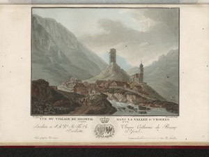
Where the roads of the Gotthard and Furka passes meet, the Disentis monastery founded a hospice in the 9th/10th century, from which the settlement of Hospental developed. In the 13th century, the von Hospental family erected the tower dominating the village in order to control pass traffic from there. Hospental was a day's walk from the Haslital over the Grimsel and Furka passes.

Aufnahmestandort
nb-482070
Ort auf moderner Karte
GEOMETRYCOLLECTION (POINT (8.57369 46.622542), LINESTRING (8.57369 46.622542, 8.572367 46.621819))
Camera Settings (3D)
{"landscape":{"viewpoint":{"bounds":[[8.57591674125905,46.616530676451816],[8.702166326245418,46.68930779222205]],"bearing":-123.55228324435359,"pitch":85,"zoom":18.371282100544168,"center":{"lng":8.573690000002784,"lat":46.62254199999742},"cam":{"center":{"lng":8.666135334405027,"lat":46.6549978387537},"zoom":12.867671502040455,"bearing":0},"cameraToCenterDistance":1918.5,"cameraPosition":{"lngLat":{"lng":8.576992749405747,"lat":46.624046334827284},"altitude":1488.939494625709},"cameraTargetElevation":1462.4605756152307}},"portrait":{"viewpoint":{"bounds":[[8.575916741258169,46.61653067651915],[8.702166325302017,46.68930779150324]],"bearing":-123.55228324435359,"pitch":85,"zoom":18.371282100544168,"center":{"lng":8.573690000001534,"lat":46.622541999998106},"cameraToCenterDistance":1918.5,"cameraPosition":{"lngLat":{"lng":8.576992749404553,"lat":46.62404633482791},"altitude":1488.9394946257087},"cameraTargetElevation":1462.4605756152307}},"square":{"viewpoint":{"bounds":[[8.5759167412578,46.61653067652952],[8.702166325343114,46.689307791493775]],"bearing":-123.55228324435359,"pitch":85,"zoom":18.371282100544168,"center":{"lng":8.573690000001761,"lat":46.62254199999691},"cam":{"center":{"lng":9.207164661684345,"lat":46.69624398510231},"zoom":8.477502556137196,"bearing":0},"cameraToCenterDistance":1918.5,"cameraPosition":{"lngLat":{"lng":8.57699274940478,"lat":46.624046334826744},"altitude":1488.9394946257091},"cameraTargetElevation":1462.4605756152307}}}
Quellen

Hans Stadler, "Hospental", in: Historisches Lexikon der Schweiz (HLS), version of 16.02.2023 [24.11.2023]; Johann Gottfried Ebel, Anleitung, auf nützlichste und genussvollste Art die Schweitz zu bereisen, vol. 3, Zurich 1810, pp. 201-202

Bilder
nb-482079
Ort
GEOMETRYCOLLECTION (POINT (8.578305 46.540768), LINESTRING (8.578305 46.540768, 8.577624 46.534488))
Titel
View of the hospice on the Gotthard Pass
Text

Even before the Schöllenen Gorge was made passable around 1200, there was a chapel dedicated to St. Gotthard at the top of the pass. With the increase in pass traffic, a hospice developed, which was destroyed by an avalanche in 1774 or 1775. Finally, in 1777, a more spacious hospital was built with a spectacular octagonal stable that could accommodate 47 animals at a time.


Ort auf moderner Karte
GEOMETRYCOLLECTION (POINT (8.567318 46.55644), LINESTRING (8.567318 46.55644, 8.567255 46.555822))
Camera Settings (3D)
{"landscape":{"viewpoint":{"bounds":[[8.48785075393016,46.4842807025573],[8.62355790081196,46.558334545584614]],"bearing":177.7115328369123,"pitch":81.52705251603692,"zoom":18.373024400554552,"center":{"lng":8.567317999996703,"lat":46.556439999999185},"cam":{"center":{"lng":8.59699033092707,"lat":46.52447662312278},"zoom":12.259981513716673,"bearing":0},"cameraToCenterDistance":1918.5,"cameraPosition":{"lngLat":{"lng":8.567161070957468,"lat":46.5591402275889},"altitude":2136.3109946105455},"cameraTargetElevation":2091.5461359011997}},"portrait":{"viewpoint":{"bounds":[[8.487850753507814,46.484280702113125],[8.623557901167828,46.55833454558507]],"bearing":177.7115328369123,"pitch":81.52705251603692,"zoom":18.373024400554552,"center":{"lng":8.567317999996135,"lat":46.55644000000004},"cameraToCenterDistance":1918.5,"cameraPosition":{"lngLat":{"lng":8.5671610709569,"lat":46.55914022758975},"altitude":2136.310994610545},"cameraTargetElevation":2091.5461359011997}},"square":{"viewpoint":{"bounds":[[8.487850752971156,46.48428070157564],[8.623557901609615,46.55833454558456]],"bearing":177.7115328369123,"pitch":81.52705251603692,"zoom":18.373024400554552,"center":{"lng":8.56731799999693,"lat":46.5564399999993},"cam":{"center":{"lng":9.166386496163454,"lat":46.56798918050961},"zoom":8.373284471686363,"bearing":0},"cameraToCenterDistance":1918.5,"cameraPosition":{"lngLat":{"lng":8.567161070957809,"lat":46.55914022758907},"altitude":2136.3109946105455},"cameraTargetElevation":2091.5461359011997}}}
Quellen

Johann Gottfried Ebel, Anleitung, auf nützlichste und genussvollste Art die Schweitz zu bereisen, vol. 3, Zurich 1810, pp. 127-128; Bundesinventar der historischen Verkehrswege der Schweiz (IVS), TI 6.1.7 (PDF) [08.12.2023]; HLS DHS DSS, "Gotthard Pass", in: Historisches Lexikon der Schweiz (HLS), version of 30.08.2016, translated from Italian [08.12.2023]

Vues remarquables des Montagnes de la Suisse : dessinés et colorés d'après nature, avec leur Description / [Préface de Monsieur le Baron de Haller ; texte de J. S. Wyttenbach ; déssiné par Caspar Wolf, Johann Wolfgang Kleemann, Friedrich Rosenberg ... et al. ; gravé par Charles Melchior Descourtis, Jean-François Janinet, Pierre Michel Alix ... et al.], Amsterdam: J. Yntema, 1785; [s.l.] : [R. S. Henzi], [ca. 1780-1794]; More on Caspar Wolf's Alpine travels can also be found here: https://diezukunftkuratieren.ch/konzept/ [22.4.2024]

Download entire document as PDF


Bitte berühren!