Voyage pittoresque de Bâle à Bienne par les Vallons de Mottiers-Grandval, 1802

On the road of the prince-bishops from Basel to Biel
Bilder
nb-1001722
Ort
GEOMETRYCOLLECTION (POINT (7.595994 47.552013), LINESTRING (7.595994 47.552013, 7.599696 47.548944))
Titel
Carte routière de Bâle à Bienne
Text

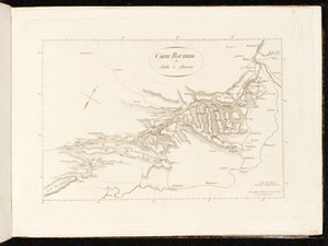
The attached map shows the route and the approximate locations from which the views were taken. It is very generalizing and also rotated clockwise by a few degrees so that north is roughly at the top right.

In 1808, the French painter Élisabeth Vigée-Lebrun (1755-1842) traveled this route on the advice of her Basel host Ethinger, as she later wrote in her memoirs:

"I took the route through the diocese of Basel to get to Biel; Mr. Ethinger had recommended this route to me. He was very right, because this route is undoubtedly the most picturesque, varied and magnificent. You see scenery there that surpasses the beauty of anything you can see in the interior of Switzerland; I was constantly in awe."


Ort auf moderner Karte
GEOMETRYCOLLECTION (POINT (7.595335 47.551086), LINESTRING (7.595335 47.551086, 7.595538 47.550836))
Camera Settings (3D)
{"landscape":{"viewpoint":{"bounds":[[7.594265934931229,47.48948156606724],[7.663796040542877,47.55163404073028]],"bearing":143.52977889838542,"pitch":80.52461159846641,"zoom":18.509957015958157,"center":{"lng":7.596349865198135,"lat":47.550171955921456},"cam":{"center":{"lng":7.652845549256568,"lat":47.52235393014692},"zoom":13.053790301912597,"bearing":0},"cameraToCenterDistance":1861.5,"cameraPosition":{"lngLat":{"lng":7.594294166038395,"lat":47.55204903689909},"altitude":322.24608632958666},"cameraTargetElevation":278.92595214833136}},"portrait":{"viewpoint":{"bounds":[[7.59357822084786,47.47021688483622],[7.685203661544847,47.552134860211254]],"bearing":143.52977889838542,"pitch":80.52461159846641,"zoom":18.111846567008662,"center":{"lng":7.596324384212494,"lat":47.55020816274481},"cameraToCenterDistance":1861.5,"cameraPosition":{"lngLat":{"lng":7.593615423259848,"lat":47.55268172829463},"altitude":335.61496755341904},"cameraTargetElevation":278.5285644530156}},"square":{"viewpoint":{"bounds":[[7.594147919670178,47.48159917469104],[7.672537630166374,47.55167642046007]],"bearing":143.52977889838542,"pitch":80.52461159846641,"zoom":18.33693049960636,"center":{"lng":7.5964973866939545,"lat":47.55002803355123},"cam":{"center":{"lng":7.692910681574972,"lat":47.521119387179226},"zoom":11.73109902695465,"bearing":0},"cameraToCenterDistance":1861.5,"cameraPosition":{"lngLat":{"lng":7.594179748016813,"lat":47.55214429529738},"altitude":329.2361344845732},"cameraTargetElevation":280.39596557621405}}}
Quellen

Souvenirs de Madame Louise-Elisabeth Vigée-Lebrun, vol. 3, Paris 1837, p. 232

Bilder
nb-477204
Ort
GEOMETRYCOLLECTION (POINT (7.615241 47.534034), LINESTRING (7.615241 47.534034, 7.61596 47.529722))
Titel
Environs de Munchenstein
Text

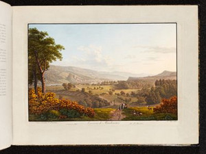
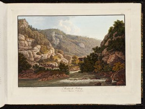
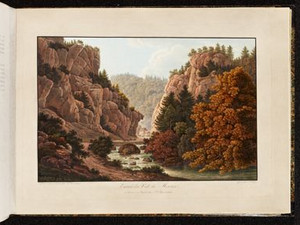
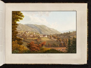
The first view opens up to the south into the Birseck. Here, at the lowest section of the Birs, history and nature come together. On the one hand, two famous battles in Swiss history took place in the area, namely at St. Jakob an der Birs in 1444 and at Dornach in 1499. In addition, three castle ruins can be seen in the view, namely Reichenstein above Arlesheim and the ruins of Pfeffingen on the right, as well as Münchenstein.

Philippe-Sirice Bridel praises the picturesque landscape with its pleasant views. A canal branching off from the Birs in the 12th century, which operated paper mills, a wire drawing mill and a copper hammer, ran through the depression on the left of the picture. The land gained in the process was called "New World" and around 1800 offered a peaceful spot with a small forest and a wooden hut. Even today, the "Park im Grünen" located here and the Merian Gardens serve as a local recreation area.

Ort auf moderner Karte
GEOMETRYCOLLECTION (POINT (7.613334 47.532677), LINESTRING (7.613334 47.532677, 7.613445 47.53228))
Camera Settings (3D)
{"landscape":{"viewpoint":{"bounds":[[7.580192683064837,47.532891461510076],[7.640189417093211,47.5624099699381]],"bearing":163.01394176760596,"pitch":84.5,"zoom":18.043535998262893,"center":{"lng":7.613943815235871,"lat":47.53119432884398},"cam":{"center":{"lng":7.626967600487063,"lat":47.54891097663946},"zoom":13.559188188031586,"bearing":0},"cameraToCenterDistance":1311.1693066899602,"cameraPosition":{"lngLat":{"lng":7.612951542028952,"lat":47.5333875701854},"altitude":294.13506598918514},"cameraTargetElevation":269.5806640297013},"image.scale":18},"portrait":{"viewpoint":{"bounds":[[7.580192683022005,47.53289146151212],[7.640189417080563,47.5624099699655]],"bearing":163.01394176760596,"pitch":84.5,"zoom":18.043535998262893,"center":{"lng":7.613943815233824,"lat":47.531194328846084},"cameraToCenterDistance":1311.1693066899602,"cameraPosition":{"lngLat":{"lng":7.612951542026849,"lat":47.53338757018753},"altitude":294.1350659891841},"cameraTargetElevation":269.5806640297013},"image.scale":19,"camera.fov":52},"square":{"viewpoint":{"bounds":[[7.580192683366249,47.5328914615134],[7.6401894168396325,47.56240996967958]],"bearing":163.01394176760596,"pitch":84.5,"zoom":18.043535998262893,"center":{"lng":7.6139438152345065,"lat":47.531194328847306},"cam":{"center":{"lng":7.880176350733052,"lat":47.56789708368834},"zoom":9.550825330884578,"bearing":0},"cameraToCenterDistance":1311.1693066899602,"cameraPosition":{"lngLat":{"lng":7.6129515420275595,"lat":47.53338757018875},"altitude":294.13506598918354},"cameraTargetElevation":269.5806640297013},"image.scale":21}}
Quellen

Voyage pittoresque de Basle à Bienne par les Vallons de Mottiers-Grandval, Basel 1802, p. 2 - 3; Brigitta Strub, "Münchenstein", in: Historisches Lexikon der Schweiz (HLS), version of 22.01.2009 [22.12.2023]

Bilder
nb-477205
Ort
GEOMETRYCOLLECTION (POINT (7.608719 47.489456), LINESTRING (7.608719 47.489456, 7.609224 47.48887))
Titel
Pont à Dornach
Text

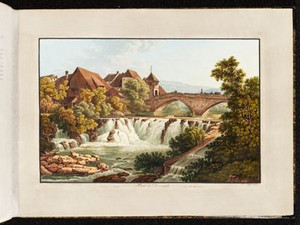
In Dornachbrugg is the Birs crossing, which brings us back onto the main road on the left bank. We are already in the canton of Solothurn. The view shows the old bridge from 1612/13 with the gate tower built at the beginning of the 16th century. Both were destroyed by floods in 1813, but only the bridge was rebuilt.


Ort auf moderner Karte
GEOMETRYCOLLECTION (POINT (7.606723 47.489206), LINESTRING (7.606723 47.489206, 7.60711 47.488822))
Camera Settings (3D)
{"landscape":{"viewpoint":{"bounds":[[7.300348361217743,47.49300005825921],[7.601578837670559,47.74142847316938]],"bearing":138.32464820203873,"pitch":84.9975464959158,"zoom":17.99710361160016,"center":{"lng":7.6040759682655334,"lat":47.49119770254006},"cam":{"center":{"lng":7.592343528506149,"lat":47.62794975831443},"zoom":10.484128869528218,"bearing":0},"cameraToCenterDistance":2158.9158187471016,"cameraPosition":{"lngLat":{"lng":7.600232661076433,"lat":47.4941148843223},"altitude":337.21870542424017},"cameraTargetElevation":299.2041015627868},"camera.fov":33,"image.scale":104},"portrait":{"viewpoint":{"bounds":[[7.5246769207150805,47.49098558688874],[7.60818912301724,47.557969275397596]],"bearing":138.32464820154496,"pitch":85,"zoom":17.461348914881302,"center":{"lng":7.607000917202981,"lat":47.488981117555056},"cameraToCenterDistance":1543.8895731375942,"cameraPosition":{"lngLat":{"lng":7.603016493771463,"lat":47.49200553522397},"altitude":338.5967375620543},"cameraTargetElevation":299.2041015627868},"image.scale":79,"camera.fov":45},"square":{"viewpoint":{"bounds":[[7.52467692138535,47.490985586888456],[7.6081891229458165,47.55796927429034]],"bearing":138.32464820154496,"pitch":85,"zoom":17.461348914881302,"center":{"lng":7.607000917202754,"lat":47.48898111755531},"cam":{"center":{"lng":7.942237929187712,"lat":47.552677396640604},"zoom":9.073722287981653,"bearing":0},"cameraToCenterDistance":1543.8895731375942,"cameraPosition":{"lngLat":{"lng":7.60301649377115,"lat":47.49200553522422},"altitude":338.59673756205405},"cameraTargetElevation":299.2041015627868},"image.scale":75}}
Bilder
nb-477206
Titel
Château d'Angenstein
Text

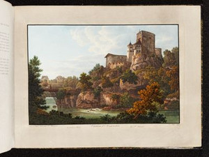
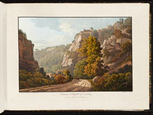
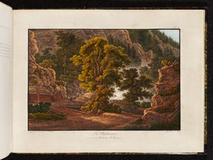
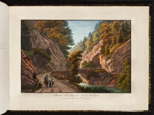
A castle was built by an unknown noble family shortly after 1286 at the point where the Birs flows through its last gorge. Its location in the rocky gorge gave it its name, which means "narrow stone". Partially destroyed in the Basel earthquake of 1356, it was rebuilt, but burned down in 1494 and 1517 and had been uninhabited since then until it was made habitable again in 1562. At the time this view was taken, the building was owned by the Noël and Grandvillars family. They had adapted the interior to contemporary tastes, as Desiré Raoul-Rochette admiringly noted in 1824.


Aufnahmestandort
nb-477206
Ort auf moderner Karte
GEOMETRYCOLLECTION (POINT (7.604191 47.462574), LINESTRING (7.604191 47.462574, 7.604218 47.462683))
Camera Settings (3D)
{"landscape":{"image.scale":49,"viewpoint":{"bounds":[[7.525286246040821,47.46100852535639],[7.646900499442495,47.53445247230161]],"bearing":-23.650428511563177,"pitch":78.00322127405838,"zoom":17.941766978319357,"center":{"lng":7.60398745536861,"lat":47.463035770734734},"cam":{"center":{"lng":7.62779481567469,"lat":47.50087372440288},"zoom":12.245536983581491,"bearing":0},"cameraToCenterDistance":1543.8895731375942,"cameraPosition":{"lngLat":{"lng":7.605679301929797,"lat":47.46042392065607},"altitude":374.96956040037145},"cameraTargetElevation":307.597900390726}},"portrait":{"viewpoint":{"bounds":[[7.567481737467261,47.46196641722025],[7.63038772121277,47.49360779580698]],"bearing":-23.650428511458358,"pitch":74.49999999999999,"zoom":18.962606884487485,"center":{"lng":7.604234218586157,"lat":47.46275832752502},"cameraToCenterDistance":1153.6885394960755,"cameraPosition":{"lngLat":{"lng":7.604848024145753,"lat":47.46181075271443},"altitude":339.4973547068796},"cameraTargetElevation":307.597900390726},"image.scale":33,"camera.fov":58},"square":{"viewpoint":{"bounds":[[7.567481737355848,47.46196641722068],[7.630387721336746,47.49360779592942]],"bearing":-23.650428511458358,"pitch":74.49999999999999,"zoom":18.962606884487485,"center":{"lng":7.604234218584679,"lat":47.46275832752528},"cam":{"center":{"lng":7.8820116572602785,"lat":47.49904350917362},"zoom":9.482512024978984,"bearing":0},"cameraToCenterDistance":1153.6885394960755,"cameraPosition":{"lngLat":{"lng":7.60484802414436,"lat":47.46181075271477},"altitude":339.49735470687943},"cameraTargetElevation":307.597900390726},"image.scale":27}}
Quellen

Voyage pittoresque de Basle à Bienne par les Vallons de Mottiers-Grandval, Basel 1802, p. 4

Bilder
nb-477207
Titel
Cascade de la Birs à Grellingen
Text

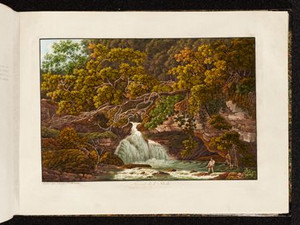
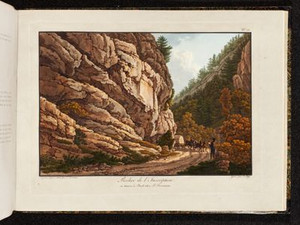
Like many rivers, the Birs used to be used to transport timber. It was floated from the Solothurn and Bernese Jura to Basel. The tree trunks were tied together and floated on the water as a raft. Obstacles, such as the waterfall near Grellingen, were overcome by means of so-called "rafting lanes", as seen here on the right.


Aufnahmestandort
nb-477207
Ort auf moderner Karte
GEOMETRYCOLLECTION (POINT (7.593473 47.442933), LINESTRING (7.593473 47.442933, 7.592711 47.442694))
Camera Settings (3D)
{"landscape":{"image.scale":20,"camera.fov":60,"viewpoint":{"bounds":[[7.593944933028922,47.43686628368397],[7.602476438868308,47.44767200819945]],"bearing":-96.97048208634958,"pitch":85,"zoom":19.205469129863666,"center":{"lng":7.592867687341595,"lat":47.442822105043405},"cam":{"center":{"lng":7.604339699395666,"lat":47.442730004966705},"zoom":15.011907512379494,"bearing":0},"cameraToCenterDistance":1107.646491440297,"cameraPosition":{"lngLat":{"lng":7.594141582762347,"lat":47.44292744167177},"altitude":327.92095929372715},"cameraTargetElevation":319.4769470442946}},"portrait":{"image.scale":15,"viewpoint":{"bounds":[[7.593868064482962,47.4373667251391],[7.601754826802022,47.44735583441587]],"bearing":-96.97048208656429,"pitch":84.99961317136808,"zoom":19.31903999276952,"center":{"lng":7.592872381210327,"lat":47.44287244481416},"cameraToCenterDistance":1107.646491440297,"cameraPosition":{"lngLat":{"lng":7.594049838827544,"lat":47.44296980704979},"altitude":327.92160931816426},"cameraTargetElevation":320.11623535133856}},"square":{"image.scale":18,"viewpoint":{"bounds":[[7.593868052881788,47.437365923738014],[7.6017559332242115,47.447356462271216]],"bearing":-96.97048208325714,"pitch":84.9992263419518,"zoom":19.319039140503588,"center":{"lng":7.5928723812101,"lat":47.44287244481413},"cam":{"center":{"lng":7.633307454593819,"lat":47.445028773722896},"zoom":12.477999714509638,"bearing":0},"cameraToCenterDistance":1107.646491440297,"cameraPosition":{"lngLat":{"lng":7.59404983882726,"lat":47.442969807049735},"altitude":327.92221621846306},"cameraTargetElevation":320.11623535133856},"camera.fov":60}}
Quellen

Albin Fringeli, Der Birs entlang. Von Flössern, Fuhrleuten und fremdem Volk, in: Jurablätter. Monatsschrift für Heimat und Volkskunde, vol. 21, issue 2, 1959, pp. 35 - 45 [29.07.2024]

Bilder
nb-477208
Ort
GEOMETRYCOLLECTION (POINT (7.571171 47.438281), LINESTRING (7.571171 47.438281, 7.570635 47.436916))
Titel
Torrent de l'Ilbech
Text

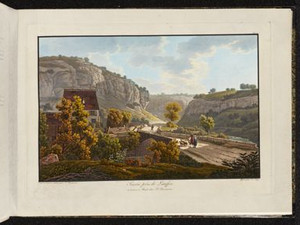
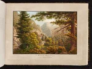
The sources of the Ibach are located near Meltingen in the canton of Solothurn. This place must have been a local fishing hotspot, because Philippe Sirice Bridel, the author of the accompanying texts to the views of this Voyage pittoresque, writes: 
"This basin with the purest water has the best supply of trout in the area: the solitary angler often casts his line here in silence and skillfully pulls out this beautiful fish hanging on the elusive hook [...]".

The view, by the way, depicts this solitary fisherman. Bridel also points out the beauty of the route, which is very rich in water; small rivers, torrents and bubbling springs adorn the entire journey from Basel to Biel.


Aufnahmestandort
nb-477208
Ort auf moderner Karte
GEOMETRYCOLLECTION (POINT (7.568917 47.437656), LINESTRING (7.568917 47.437656, 7.568802 47.437138))
Camera Settings (3D)
{"landscape":{"image.scale":33,"viewpoint":{"bounds":[[7.561383738348667,47.438246196464235],[7.586862287868598,47.447340254674515]],"bearing":-169.70138083423285,"pitch":84.58166939229808,"zoom":18.74076713613851,"center":{"lng":7.5687962025208435,"lat":47.43726039738843},"cam":{"center":{"lng":7.579590838937065,"lat":47.443204313002866},"zoom":15.176595094221724,"bearing":0},"cameraToCenterDistance":1107.646491440297,"cameraPosition":{"lngLat":{"lng":7.569112627749831,"lat":47.438438271724806},"altitude":350.8550264337775},"cameraTargetElevation":338.2285157443496}},"portrait":{"image.scale":22,"viewpoint":{"bounds":[[7.561383738309331,47.43824619646398],[7.5868622879371515,47.44734025470993]],"bearing":-169.70138083423285,"pitch":84.58166939229808,"zoom":18.74076713613851,"center":{"lng":7.568796202520389,"lat":47.437260397388116},"cameraToCenterDistance":1107.646491440297,"cameraPosition":{"lngLat":{"lng":7.56911262774932,"lat":47.43843827172449},"altitude":350.8550264337776},"cameraTargetElevation":338.2285157443496}},"square":{"image.scale":35,"viewpoint":{"bounds":[[7.561383738364327,47.43824619646469],[7.586862287861976,47.447340254665505]],"bearing":-169.70138083423285,"pitch":84.58166939229808,"zoom":18.74076713613851,"center":{"lng":7.568796202521412,"lat":47.437260397388854},"cam":{"center":{"lng":7.688776485852458,"lat":47.45140861926882},"zoom":10.786426139285116,"bearing":0},"cameraToCenterDistance":1107.646491440297,"cameraPosition":{"lngLat":{"lng":7.569112627750428,"lat":47.43843827172526},"altitude":350.8550264337774},"cameraTargetElevation":338.2285157443496}}}
Quellen

Voyage pittoresque de Basle à Bienne par les Vallons de Mottiers-Grandval, Basel 1802, p. 6

Bilder
nb-477209
Titel
Pont et Cascade de Laufen
Text

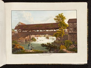
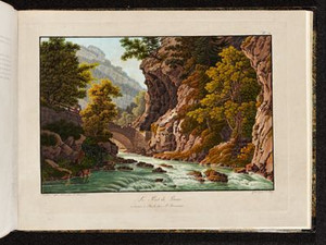
"At the gates of Laufen, a small town that only deserves this name because of the almost regular enclosure and the almost imposing wall that surrounds it, the Birsig falls away in a charming drop that is all the more remarkable here because art has not remained uninvolved. A wooden bridge that swings gently from one bank to the other looks as if it had been thrown there specifically to frame the landscape."


Aufnahmestandort
nb-477209
Ort auf moderner Karte
GEOMETRYCOLLECTION (POINT (7.500905 47.420498), LINESTRING (7.500905 47.420498, 7.501076 47.419515))
Camera Settings (3D)
{"landscape":{"image.scale":43,"viewpoint":{"bounds":[[7.486454832779714,47.421327160507104],[7.530404656480414,47.4362107919674]],"bearing":-173.44835186872558,"pitch":84,"zoom":18.27613718874677,"center":{"lng":7.500818967819214,"lat":47.419961965772444},"cam":{"center":{"lng":7.517861599492846,"lat":47.429478465228044},"zoom":14.390020864118334,"bearing":0},"cameraToCenterDistance":1107.646491440297,"cameraPosition":{"lngLat":{"lng":7.501097364244714,"lat":47.421602082624105},"altitude":373.63275094930174},"cameraTargetElevation":354.33828124996603}},"portrait":{"viewpoint":{"bounds":[[7.486454832574452,47.4213271605048],[7.530404656908161,47.436210792167515]],"bearing":-173.44835186872558,"pitch":84,"zoom":18.27613718874677,"center":{"lng":7.500818967819555,"lat":47.41996196576997},"cameraToCenterDistance":1107.646491440297,"cameraPosition":{"lngLat":{"lng":7.501097364245055,"lat":47.42160208262163},"altitude":373.63275094930265},"cameraTargetElevation":354.33828124996603},"image.scale":44},"square":{"viewpoint":{"bounds":[[7.486454832796056,47.42132716050676],[7.530404656463389,47.43621079194807]],"bearing":-173.44835186872558,"pitch":84,"zoom":18.27613718874677,"center":{"lng":7.500818967818532,"lat":47.419961965771904},"cam":{"center":{"lng":7.706203951132778,"lat":47.443633568605804},"zoom":9.999851909012424,"bearing":0},"cameraToCenterDistance":1107.646491440297,"cameraPosition":{"lngLat":{"lng":7.5010973642440035,"lat":47.421602082623565},"altitude":373.6327509493019},"cameraTargetElevation":354.33828124996603},"image.scale":44}}
Quellen

Desiré Raoul-Rochette, Lettres sur la Suisse, Paris 1828, p. 51 - 52

Bilder
nb-477210
Ort
GEOMETRYCOLLECTION (POINT (7.489117 47.413667), LINESTRING (7.489117 47.413667, 7.491263 47.414091))
Titel
Scierie près de Laufen
Text

At the confluence of the Lützel and Birs rivers, a sawmill uses water power and the easy transportation of timber on the river. "There is a sawmill nearby, half hidden in the forest, as is the owner's simple home. All around are piles of already processed boards and logs that will soon break under the sharp teeth of the constantly working iron, and in the shadows you can make out the sluice that supplies the water, the wheel turned by the current and the tireless saw, whose slow and dull sound seems to join the murmur of the Lucelle to invite you to rest."

Ort auf moderner Karte
GEOMETRYCOLLECTION (POINT (7.493798 47.411098), LINESTRING (7.493798 47.411098, 7.49501 47.411216))
Camera Settings (3D)
{"landscape":{"image.scale":47,"viewpoint":{"bounds":[[7.465143476497957,47.39576935814836],[7.492907637374429,47.41840805824816]],"bearing":59.39190621613056,"pitch":85,"zoom":17.933673076327207,"center":{"lng":7.494923472409141,"lat":47.41152230741119},"cam":{"center":{"lng":7.4918576627384255,"lat":47.40805486840881},"zoom":13.945876345401421,"bearing":0},"cameraToCenterDistance":1107.646491440297,"cameraPosition":{"lngLat":{"lng":7.492256361141784,"lat":47.410454532401246},"altitude":380.77151969138447},"cameraTargetElevation":360.37031249994277}},"portrait":{"image.scale":39,"viewpoint":{"bounds":[[7.465143476581488,47.39576935820341],[7.492907637371417,47.41840805822068]],"bearing":59.39190621613056,"pitch":85,"zoom":17.933673076327207,"center":{"lng":7.494923472405958,"lat":47.41152230741045},"cameraToCenterDistance":1107.646491440297,"cameraPosition":{"lngLat":{"lng":7.492256361138573,"lat":47.41045453240051},"altitude":380.77151969138475},"cameraTargetElevation":360.37031249994277}},"square":{"image.scale":47,"viewpoint":{"bounds":[[7.465143476587826,47.39576935819903],[7.492907637371616,47.418408058220194]],"bearing":59.39190621613056,"pitch":85,"zoom":17.933673076327207,"center":{"lng":7.494923472406185,"lat":47.4115223074098},"cam":{"center":{"lng":7.603964280506773,"lat":47.41648426865646},"zoom":10.662485497283171,"bearing":0},"cameraToCenterDistance":1107.646491440297,"cameraPosition":{"lngLat":{"lng":7.492256361138885,"lat":47.410454532399825},"altitude":380.771519691385},"cameraTargetElevation":360.37031249994277}}}
Quellen

Voyage pittoresque de Basle à Bienne par les Vallons de Mottiers-Grandval, Basel 1802, p. 8

Bilder
nb-477211
Ort
GEOMETRYCOLLECTION (POINT (7.468563 47.404162), LINESTRING (7.468563 47.404162, 7.479161 47.404743))
Titel
Verrerie près de Laufen
Text

At the mouth of the Bärschwilertal valley (right-hand edge of the picture) there was already an iron smelter in the 17th century. On the opposite bank of the Birs, a glassworks began operations in 1775/83 (depending on the source). It was abandoned in 1865, after allegedly still employing 150 people in the 1820s!


Ort auf moderner Karte
GEOMETRYCOLLECTION (POINT (7.473274 47.40063), LINESTRING (7.473274 47.40063, 7.474614 47.400832))
Camera Settings (3D)
{"landscape":{"image.scale":31,"viewpoint":{"bounds":[[7.452792321497043,47.38980529794455],[7.471924035352771,47.41561059338275]],"bearing":85.88148885912801,"pitch":84.70039844711665,"zoom":18.116294527970368,"center":{"lng":7.474232912063599,"lat":47.40069215388323},"cam":{"center":{"lng":7.476983962814018,"lat":47.403809440108915},"zoom":13.75712028822544,"bearing":0},"cameraToCenterDistance":1107.646491440297,"cameraPosition":{"lngLat":{"lng":7.4715108234836975,"lat":47.40055948389181},"altitude":384.3010047854694},"cameraTargetElevation":365.2474609371608}},"portrait":{"viewpoint":{"bounds":[[7.452792321312387,47.38980529783129],[7.471924035358484,47.41561059352091]],"bearing":85.88148885912801,"pitch":84.70039844711665,"zoom":18.116294527970368,"center":{"lng":7.47423291206951,"lat":47.400692153882744},"cameraToCenterDistance":1107.646491440297,"cameraPosition":{"lngLat":{"lng":7.471510823489524,"lat":47.40055948389136},"altitude":384.30100478546956},"cameraTargetElevation":365.2474609371608},"image.scale":30},"square":{"image.scale":33,"viewpoint":{"bounds":[[7.452792321155783,47.389805297739684],[7.4719240353598195,47.415610593660205]],"bearing":85.88148885912801,"pitch":84.70039844711665,"zoom":18.116294527970368,"center":{"lng":7.474232912070875,"lat":47.400692153883284},"cam":{"center":{"lng":7.548450892175964,"lat":47.40918369369831},"zoom":11.199743140968867,"bearing":0},"cameraToCenterDistance":1107.646491440297,"cameraPosition":{"lngLat":{"lng":7.471510823490917,"lat":47.40055948389187},"altitude":384.30100478546933},"cameraTargetElevation":365.2474609371608}}}
Quellen

Robert Glutz von Blotzheim, Handbuch für Reisende in der Schweiz, 5th edition, Zurich 1823, p. 272; Lukas Schenker, "Bärschwil", in: Historisches Lexikon der Schweiz (HLS), version of 15.09.2009 [05.01.2024]; Gottlieb Loertscher, Die Kunstdenkmäler des Kantons Solothurn, vol. 3, p. 147 [29.07.2024]

Bilder
nb-477212
Ort
GEOMETRYCOLLECTION (POINT (7.43577 47.401254), LINESTRING (7.43577 47.401254, 7.431831 47.39701))
Titel
Moulin de Liesberg
Text

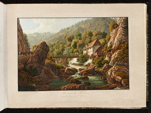
About three kilometers upstream is another old industrial site. The Liesberg grain mill has existed since at least 1602, and around 20 years later a sawmill and a grater were added. Graters were used to extract plant fibers from hemp or flax, which were needed for textile production. Just below the mill, a bridge first mentioned in 1467 and which collapsed in 1935 led over the Birs.


Ort auf moderner Karte
GEOMETRYCOLLECTION (POINT (7.437919 47.39728), LINESTRING (7.437919 47.39728, 7.436588 47.395483))
Camera Settings (3D)
{"landscape":{"image.scale":50,"viewpoint":{"bounds":[[7.43618223672442,47.39834084103691],[7.464797262386014,47.41201609306785]],"bearing":-147.68670595085598,"pitch":85,"zoom":18.132648316333,"center":{"lng":7.437662333250046,"lat":47.397115499501695},"cam":{"center":{"lng":7.458240897545608,"lat":47.405761802054286},"zoom":14.673152384641488,"bearing":0},"cameraToCenterDistance":1107.646491440297,"cameraPosition":{"lngLat":{"lng":7.439105425113667,"lat":47.39865990360147},"altitude":401.37899032204473},"cameraTargetElevation":383.6012268066404}},"portrait":{"image.scale":50,"viewpoint":{"bounds":[[7.436182236715325,47.3983408410362],[7.464797262376891,47.41201609306904]],"bearing":-147.68670595085598,"pitch":85,"zoom":18.132648316333,"center":{"lng":7.437662333248454,"lat":47.39711549950104},"cameraToCenterDistance":1107.646491440297,"cameraPosition":{"lngLat":{"lng":7.439105425112018,"lat":47.398659903600816},"altitude":401.37899032204496},"cameraTargetElevation":383.6012268066404}},"square":{"image.scale":51,"viewpoint":{"bounds":[[7.436182236723056,47.39834084103512],[7.464797262398065,47.412016093075266]],"bearing":-147.68670595085598,"pitch":85,"zoom":18.132648316333,"center":{"lng":7.437662333248227,"lat":47.39711549950002},"cam":{"center":{"lng":7.579257365098158,"lat":47.41486148042512},"zoom":10.618936384749404,"bearing":0},"cameraToCenterDistance":1107.646491440297,"cameraPosition":{"lngLat":{"lng":7.439105425111762,"lat":47.398659903599764},"altitude":401.3789903220453},"cameraTargetElevation":383.6012268066404}}}
Bilder
nb-477213
Ort
GEOMETRYCOLLECTION (POINT (7.357449 47.3842), LINESTRING (7.357449 47.3842, 7.353463 47.379087))
Titel
Château et Chapelle de Vorburg
Text

These two constructions, perched on a ridge above the Birsklus north of Delsberg, are the only ruins of the outer castle. There is a small chapel on the left and a single tower on the right, which was the watchtower of the upper castle. According to legend, the chapel was consecrated by Pope Leo IX in 1049. In 1356, the Basel earthquake partially destroyed the two castles. However, one of the castles remained inhabited in the centuries that followed. From the 17th century onwards, the castle chapel developed into an important place of pilgrimage. The reason for this was a miraculous statue of the Virgin Mary, which was kept hidden by the local population during the French occupation from 1794 to 1803. Pilgrims came and still come not only from the Jura, but also from neighboring Catholic regions such as Laufental, Solothurn, Central Switzerland and Alsace.


Ort auf moderner Karte
GEOMETRYCOLLECTION (POINT (7.360626 47.381352), LINESTRING (7.360626 47.381352, 7.359789 47.38073))
Camera Settings (3D)
{"landscape":{"image.scale":61,"viewpoint":{"bounds":[[7.34786309272701,47.38209085725731],[7.413476686500701,47.40947911849514]],"bearing":-157.93128066348044,"pitch":85,"zoom":17.068394979342226,"center":{"lng":7.35909640789032,"lat":47.37918408773015},"cam":{"center":{"lng":7.3961908192388535,"lat":47.39695415262929},"zoom":13.671419317316632,"bearing":0},"cameraToCenterDistance":1107.646491440297,"cameraPosition":{"lngLat":{"lng":7.3612174119653275,"lat":47.38272650854958},"altitude":458.77920497675495},"cameraTargetElevation":421.5916992187509}},"portrait":{"image.scale":50,"viewpoint":{"bounds":[[7.359662939748517,47.38223898213127],[7.665526974671593,47.58136770390888]],"bearing":-153.9312806634804,"pitch":84.5,"zoom":17.718340146946716,"center":{"lng":7.359321713447571,"lat":47.379532804658396},"cameraToCenterDistance":1911.26403367408,"cameraPosition":{"lngLat":{"lng":7.362047586682991,"lat":47.383305617866114},"altitude":454.5125350694648},"cameraTargetElevation":409.54101562499983},"camera.fov":37},"square":{"image.scale":50,"viewpoint":{"bounds":[[7.359662939607176,47.382238982130104],[7.6655269754187145,47.581367704526116]],"bearing":-153.9312806634804,"pitch":84.5,"zoom":17.718340146946716,"center":{"lng":7.359321713445638,"lat":47.37953280465737},"cam":{"center":{"lng":8.888983118664868,"lat":47.58515102561796},"zoom":7.200890709710331,"bearing":0},"cameraToCenterDistance":1911.26403367408,"cameraPosition":{"lngLat":{"lng":7.3620475866810295,"lat":47.38330561786512},"altitude":454.5125350694657},"cameraTargetElevation":409.54101562499983}}}
Bilder
nb-477214
Ort
GEOMETRYCOLLECTION (POINT (7.351321 47.360784), LINESTRING (7.351321 47.360784, 7.340251 47.369969))
Titel
Delémont
Text

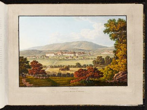
After the Vorburg ravine, the wide Delsberg basin opens up surprisingly. The town of Delémont lies on its northern edge on a slightly elevated terrain terrace. Around 1800, the town had around 1000 inhabitants and - like the entire prince-bishopric - belonged to France. Before the French Revolution, which Delémont joined in 1793, there was an Ursuline and a Capuchin convent. In 1815, the town became part of the Canton of Bern, and in 1979 it became the capital of the newly created Canton of Jura. A contemporary travel writer gave the town a good review: "The town itself has a pleasing appearance, wide, mostly straight streets adorned with pretty houses."

Ort auf moderner Karte
GEOMETRYCOLLECTION (POINT (7.355782 47.358902), LINESTRING (7.355782 47.358902, 7.354054 47.359852))
Camera Settings (3D)
{"landscape":{"camera.fov":56,"image.scale":38,"viewpoint":{"bounds":[[7.343322459660044,47.31814892558995],[7.403322645608455,47.35885087682772]],"bearing":-38.90456599787615,"pitch":84.5,"zoom":17.45807255909836,"center":{"lng":7.353828549385071,"lat":47.36053163708925},"cam":{"center":{"lng":7.396363315487463,"lat":47.34023867619348},"zoom":13.101445803997553,"bearing":0},"cameraToCenterDistance":1202.7245745889793,"cameraPosition":{"lngLat":{"lng":7.356764631379292,"lat":47.35806717054686},"altitude":447.6502427674071},"cameraTargetElevation":413.74335937525785}},"portrait":{"image.scale":38,"viewpoint":{"bounds":[[7.343322459590297,47.318148925404216],[7.403322645821191,47.35885087683042]],"bearing":-38.90456599787615,"pitch":84.5,"zoom":17.45807255909836,"center":{"lng":7.353828549382001,"lat":47.360531637092066},"cameraToCenterDistance":1202.7245745889793,"cameraPosition":{"lngLat":{"lng":7.356764631376251,"lat":47.358067170549646},"altitude":447.6502427674053},"cameraTargetElevation":413.74335937525785}},"square":{"image.scale":38,"viewpoint":{"bounds":[[7.343322459704353,47.31814892576452],[7.403322645416637,47.3588508768311]],"bearing":-38.90456599787615,"pitch":84.5,"zoom":17.45807255909836,"center":{"lng":7.353828549380978,"lat":47.36053163709283},"cam":{"center":{"lng":7.643323388265799,"lat":47.35882994158442},"zoom":9.550742319953374,"bearing":0},"cameraToCenterDistance":1202.7245745889793,"cameraPosition":{"lngLat":{"lng":7.356764631375199,"lat":47.358067170550385},"altitude":447.6502427674048},"cameraTargetElevation":413.74335937525785}}}
Quellen

François Kohler, "Delsberg (municipality)", in: Historisches Lexikon der Schweiz (HLS), version of 15.06.2020, translated from French [08.01.2024]; François Kohler; François Schifferdecker, "Jura (canton)", in: Historisches Lexikon der Schweiz (HLS), version of 19.09.2019, translated from French [08.01.2024]; Heinrich Heidegger, Handbuch für Reisende in der Schweiz, 4th edition, Zurich 1818, p. 176

Bilder
nb-477215
Ort
GEOMETRYCOLLECTION (POINT (7.369886 47.334606), LINESTRING (7.369886 47.334606, 7.37647 47.33087))
Titel
Cascade de la Birs à Courrendlin
Text

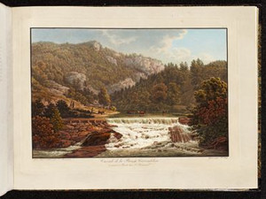
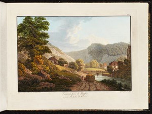
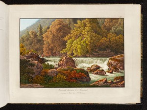
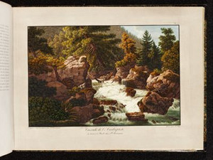
In Courrendlin, the traveler leaves the plain of Delsberg and enters the gorges of the Jura, more precisely the Probstei Moutier (Münstertal). In 1802, there was a large iron foundry in Courrendlin. Although, according to Bridel, the forges at night are comparable to the caves of Mount Etna, the most beautiful adornment of Courrendlin remains the waterfall of the Birs. He describes it as follows:

"This waterfall is not high; but its merit does not lie in its height: but the scene which surrounds it infinitely enhances this rural decoration. There are hills of various sizes, peopled by trees of various leaves; little strips of turf scattered in dense groves; stony steps rising gradually [...]. The thicket of these groves, the rich vegetation of these pastures, this zephyr whose sweet breath is refreshed by the Birs, [...] this silence, broken only by the murmur of the river, make of this place a truly Arcadian landscape, where the eyes and the heart linger at will on the happiest images".


Ort auf moderner Karte
GEOMETRYCOLLECTION (POINT (7.373127 47.333341), LINESTRING (7.373127 47.333341, 7.373586 47.332977))
Camera Settings (3D)
{"landscape":{"camera.fov":48,"image.scale":50,"viewpoint":{"bounds":[[7.32963435244352,47.33379858639921],[7.372307176606682,47.36910451608074]],"bearing":129.82835707958384,"pitch":85,"zoom":18.07387317176341,"center":{"lng":7.374376952648163,"lat":47.33282599323613},"cam":{"center":{"lng":7.370961824593934,"lat":47.352959363408615},"zoom":13.306279311438054,"bearing":0},"cameraToCenterDistance":1436.3405169117464,"cameraPosition":{"lngLat":{"lng":7.371576691335662,"lat":47.33440878627209},"altitude":473.57794497983355},"cameraTargetElevation":449.53676757850195}},"portrait":{"image.scale":50,"viewpoint":{"bounds":[[7.324256790235182,47.33380074095979],[7.371929226959821,47.37324161920591]],"bearing":129.82835707958384,"pitch":85,"zoom":17.914035394714404,"center":{"lng":7.374241501092911,"lat":47.33271419618276},"cameraToCenterDistance":1436.3405169117464,"cameraPosition":{"lngLat":{"lng":7.371113156929681,"lat":47.33448243228344},"altitude":473.57791787430426},"cameraTargetElevation":446.7199829100594}},"square":{"image.scale":50,"viewpoint":{"bounds":[[7.324256790239247,47.33380074095933],[7.371929226960987,47.37324161939276]],"bearing":129.82835707958384,"pitch":85,"zoom":17.914035394714404,"center":{"lng":7.374241501093707,"lat":47.33271419618222},"cam":{"center":{"lng":7.562618973847947,"lat":47.369670784421004},"zoom":9.882553917115134,"bearing":0},"cameraToCenterDistance":1436.3405169117464,"cameraPosition":{"lngLat":{"lng":7.37111315693042,"lat":47.33448243228287},"altitude":473.5779178743045},"cameraTargetElevation":446.7199829100594}}}
Quellen

Voyage pittoresque de Basle à Bienne par les Vallons de Mottiers-Grandval, Basel 1802, p. 13

Bilder
nb-477216
Ort
GEOMETRYCOLLECTION (POINT (7.375993 47.330461), LINESTRING (7.375993 47.330461, 7.369085 47.326069))
Titel
Entrée du Val de Moutier
Text

Always following the Birs, the traveler is then led into the Vallée de Moutier, which cuts through the great Jura chain.
"The further one advances, the greater the astonishment. On the one hand, it is nature that lavishes with inexhaustible abundance all that is richest, most sublime and most improbable in rocks, waters, forests, forms, shadows and accidents of all kinds; on the other hand, it is the irresistible disorder caused and intensified by earthquakes, floods and the heavy, destructive course of the centuries that disturbs and confuses the original distribution of all these treasures [...]."

Ort auf moderner Karte
GEOMETRYCOLLECTION (POINT (7.378139 47.327128), LINESTRING (7.378139 47.327128, 7.375069 47.323995))
Camera Settings (3D)
{"landscape":{"camera.fov":46,"image.scale":56,"viewpoint":{"bounds":[[7.369263925113955,47.32801786837095],[7.4717759572099,47.383744240133325]],"bearing":-154.549518278684,"pitch":85,"zoom":17.345034208756847,"center":{"lng":7.376353740693958,"lat":47.325015990891075},"cam":{"center":{"lng":7.452076194059686,"lat":47.358263640096425},"zoom":12.64770838279053,"bearing":0},"cameraToCenterDistance":1506.5675879442902,"cameraPosition":{"lngLat":{"lng":7.3790776106289115,"lat":47.328895415578586},"altitude":496.847226190685},"cameraTargetElevation":455.0494140623256}},"portrait":{"viewpoint":{"bounds":[[7.367049212610681,47.328248373798544],[7.454594007819594,47.37429403271909]],"bearing":-157.74951827868398,"pitch":85,"zoom":17.60836799552502,"center":{"lng":7.376978695392609,"lat":47.32565959619757},"cameraToCenterDistance":1506.5675879442902,"cameraPosition":{"lngLat":{"lng":7.3789783903189345,"lat":47.32897258410344},"altitude":496.8472715863242},"cameraTargetElevation":462.0234130859392},"image.scale":46},"square":{"image.scale":55,"viewpoint":{"bounds":[[7.367049212598943,47.32824837379843],[7.454594007828206,47.3742940327312]],"bearing":-157.74951827868398,"pitch":85,"zoom":17.60836799552502,"center":{"lng":7.376978695393063,"lat":47.32565959619748},"cam":{"center":{"lng":7.80477318874523,"lat":47.380923766668445},"zoom":9.005687876950352,"bearing":0},"cameraToCenterDistance":1506.5675879442902,"cameraPosition":{"lngLat":{"lng":7.378978390319389,"lat":47.32897258410338},"altitude":496.84727158632427},"cameraTargetElevation":462.0234130859392}}}
Quellen

Voyage pittoresque de Basle à Bienne par les Vallons de Mottiers-Grandval, Basel 1802, p. 34

Bilder
nb-477217
Ort
GEOMETRYCOLLECTION (POINT (7.375174 47.32841), LINESTRING (7.375174 47.32841, 7.373638 47.320649))
Titel
Martinet de Roche
Text

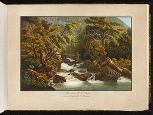
Water power was not only used to grind grain, but also in metalworking. In the Roches hammer mill, the water set a small wheel in motion, which in turn drove a hammer via a camshaft. This meant that the iron ore mined in the area could be processed quickly and much less muscle power was needed to shape it into plates, ingots or knives.


Ort auf moderner Karte
GEOMETRYCOLLECTION (POINT (7.376253 47.325357), LINESTRING (7.376253 47.325357, 7.376166 47.320557))
Camera Settings (3D)
{"landscape":{"camera.fov":56,"image.scale":39,"viewpoint":{"bounds":[[7.373021323154347,47.32591666280976],[7.4002882099114515,47.33868417478749]],"bearing":-153.38160982726436,"pitch":84.5,"zoom":18.796053092266472,"center":{"lng":7.376049309968721,"lat":47.325038717198225},"cam":{"center":{"lng":7.393881414236603,"lat":47.332845004730956},"zoom":14.774235817254741,"bearing":0},"cameraToCenterDistance":1202.7245745889793,"cameraPosition":{"lngLat":{"lng":7.376877903588024,"lat":47.32615940105569},"altitude":473.8799597670213},"cameraTargetElevation":460.45825805664185}},"portrait":{"viewpoint":{"bounds":[[7.373021323159577,47.32591666280922],[7.400288209930835,47.33868417478868]],"bearing":-153.38160982726436,"pitch":84.5,"zoom":18.796053092266472,"center":{"lng":7.376049309969176,"lat":47.3250387171976},"cameraToCenterDistance":1202.7245745889793,"cameraPosition":{"lngLat":{"lng":7.376877903588479,"lat":47.32615940105504},"altitude":473.8799597670215},"cameraTargetElevation":460.45825805664185},"image.scale":40},"square":{"image.scale":40,"viewpoint":{"bounds":[[7.373021323160685,47.325916662809306],[7.4002882099212,47.33868417478621]],"bearing":-153.38160982726436,"pitch":84.5,"zoom":18.796053092266472,"center":{"lng":7.376049309968721,"lat":47.325038717197714},"cam":{"center":{"lng":7.509355756963231,"lat":47.34153999779983},"zoom":10.688559298413555,"bearing":0},"cameraToCenterDistance":1202.7245745889793,"cameraPosition":{"lngLat":{"lng":7.376877903587996,"lat":47.32615940105518},"altitude":473.87995976702143},"cameraTargetElevation":460.45825805664185}}}
Quellen
Bilder
nb-477218
Ort
GEOMETRYCOLLECTION (POINT (7.37441 47.326242), LINESTRING (7.37441 47.326242, 7.378186 47.316817))
Titel
Cascade derrière le Martinet
Text

Click on "Open image details" for more information.

Ort auf moderner Karte
GEOMETRYCOLLECTION (POINT (7.376204 47.324949), LINESTRING (7.376204 47.324949, 7.376666 47.32331))
Camera Settings (3D)
{"landscape":{"image.scale":45,"viewpoint":{"bounds":[[7.370900767202585,47.325792737529866],[7.396320404191499,47.33643995994689]],"bearing":-162.64567540992135,"pitch":85,"zoom":18.704755119730837,"center":{"lng":7.376237064596012,"lat":47.32474418346888},"cam":{"center":{"lng":7.389636975201739,"lat":47.331570442704304},"zoom":15.036268460522965,"bearing":0},"cameraToCenterDistance":1202.7245745889793,"cameraPosition":{"lngLat":{"lng":7.3768251964714295,"lat":47.32601985858054},"altitude":473.12658147839426},"cameraTargetElevation":460.12438964843864}},"portrait":{"image.scale":43,"viewpoint":{"bounds":[[7.370900767250475,47.325792737530264],[7.396320404040836,47.33643995989243]],"bearing":-162.64567540992135,"pitch":85,"zoom":18.704755119730837,"center":{"lng":7.376237064597831,"lat":47.32474418346925},"cameraToCenterDistance":1202.7245745889793,"cameraPosition":{"lngLat":{"lng":7.376825196473277,"lat":47.32601985858088},"altitude":473.12658147839414},"cameraTargetElevation":460.12438964843864}},"square":{"viewpoint":{"bounds":[[7.370900767251783,47.32579273753166],[7.39632040404814,47.33643995989564]],"bearing":-162.64567540992135,"pitch":85,"zoom":18.704755119730837,"center":{"lng":7.376237064599991,"lat":47.3247441834707},"cam":{"center":{"lng":7.497998951233512,"lat":47.339730126712396},"zoom":10.789765869288617,"bearing":0},"cameraToCenterDistance":1202.7245745889793,"cameraPosition":{"lngLat":{"lng":7.376825196475465,"lat":47.326019858582356},"altitude":473.1265814783938},"cameraTargetElevation":460.12438964843864},"image.scale":41}}
Bilder
nb-477219
Ort
GEOMETRYCOLLECTION (POINT (7.379626 47.317734), LINESTRING (7.379626 47.317734, 7.388657 47.315086))
Titel
Morceau de la Birs
Text

"At the end of the gorge, the Birs spreads out more or less quickly in the meanders of the channel it has dug for itself: A great number of boulders, detached from the heights, rise from the middle of the riverbed, like islands covered with moss, overgrown and framed with young fir trees, some white in the spray of the bubbling river, others blue in the mirror of the calmer water: nothing is lacking in this melancholy and sublime solitude to make it the first of English gardens [....]."

The comparison with an English garden is no coincidence, as the hermitage around Birseck Castle near Arlesheim opened its doors in 1785. It adopted the English principle of imitating natural landscape forms in its park design, in contrast to the French baroque garden, where straight lines and symmetry predominated.


Ort auf moderner Karte
GEOMETRYCOLLECTION (POINT (7.383661 47.316541), LINESTRING (7.383661 47.316541, 7.385956 47.316214))
Camera Settings (3D)
{"landscape":{"camera.fov":50,"image.scale":47,"viewpoint":{"bounds":[[7.354051616326558,47.311300904290846],[7.382051589106425,47.33885578935295]],"bearing":107.8455995354559,"pitch":85,"zoom":18.424588612112945,"center":{"lng":7.3841415345791575,"lat":47.316429291486344},"cam":{"center":{"lng":7.383646044774451,"lat":47.32625463089158},"zoom":13.664602351036159,"bearing":0},"cameraToCenterDistance":1371.4121756658628,"cameraPosition":{"lngLat":{"lng":7.381542717065599,"lat":47.31699650870874},"altitude":497.4533720096351},"cameraTargetElevation":479.4470398367514}},"portrait":{"viewpoint":{"bounds":[[7.3540516162951235,47.31130090429562],[7.38205158910236,47.33885578938708]],"bearing":107.8455995354559,"pitch":85,"zoom":18.424588612112945,"center":{"lng":7.384141534575178,"lat":47.31642929148822},"cameraToCenterDistance":1371.4121756658628,"cameraPosition":{"lngLat":{"lng":7.381542717061649,"lat":47.31699650871059},"altitude":497.45337200963445},"cameraTargetElevation":479.4470398367514}},"square":{"viewpoint":{"bounds":[[7.354051616310926,47.311300904301845],[7.3820515890977845,47.33885578937844]],"bearing":107.8455995354559,"pitch":85,"zoom":18.424588612112945,"center":{"lng":7.384141534570404,"lat":47.316429291489555},"cam":{"center":{"lng":7.494051480245133,"lat":47.33456901265032},"zoom":10.650283861087786,"bearing":0},"cameraToCenterDistance":1371.4121756658628,"cameraPosition":{"lngLat":{"lng":7.381542717056817,"lat":47.316996508711924},"altitude":497.453372009634},"cameraTargetElevation":479.4470398367514},"image.scale":41}}
Quellen

Philippe-Sirice Bridel, Course de Bale a Bienne par les Vallées du Jura, Basel 1789, pp. 84-85; https://ermitage-arlesheim.ch/de/geschichte [25.10.2024]

Bilder
nb-477220
Ort
GEOMETRYCOLLECTION (POINT (7.378884 47.318164), POINT (7.378884 47.318164), LINESTRING (7.378884 47.318164, 7.3811 47.317283))
Titel
Cascade de l'Anabaptiste
Text

Philippe-Sirice Bridel tells the following story in his accompanying text: "At the beginning of the last century, a Baptist from the valley of Moutier, with a white beard, linen robe and a hat without a button, was resting here on an old tree trunk on the banks of the Birs. He sees a stranger coming in great excitement (it was a traveling merchant) and notices that he is shedding tears. Here is the short dialog they had with each other. - What ails you that you weep so? - I am ruined, the robbers have taken everything from me, I have nothing left. - Has God been taken from you too? - No - well, then don't say that everything has been taken from me. Here," adds the Baptist, pressing his purse into his hand, "here, brother, this is what the good Lord tells me to give you from him."


Ort auf moderner Karte
GEOMETRYCOLLECTION (POINT (7.387168 47.316211), LINESTRING (7.387168 47.316211, 7.389297 47.315465))
Camera Settings (3D)
{"landscape":{"viewpoint":{"bounds":[[7.365736987012639,47.31083509055253],[7.385541706968894,47.33170515762151]],"bearing":101.63125505057405,"pitch":85,"zoom":18.866771540597668,"center":{"lng":7.387150973083976,"lat":47.31621290136704},"cam":{"center":{"lng":7.387449724208835,"lat":47.32216071365028},"zoom":14.065579243054218,"bearing":0},"cameraToCenterDistance":1371.4121756658628,"cameraPosition":{"lngLat":{"lng":7.385182770863992,"lat":47.316487561199125},"altitude":495.87172903217606},"cameraTargetElevation":482.61865234375136}},"portrait":{"viewpoint":{"bounds":[[7.3657369870591936,47.31083509056057],[7.38554170696699,47.331705157573765]],"bearing":101.63125505057405,"pitch":85,"zoom":18.866771540597668,"center":{"lng":7.3871509730820435,"lat":47.31621290136704},"cameraToCenterDistance":1371.4121756658628,"cameraPosition":{"lngLat":{"lng":7.385182770862059,"lat":47.316487561199125},"altitude":495.87172903217606},"cameraTargetElevation":482.61865234375136}},"square":{"viewpoint":{"bounds":[[7.365736986714495,47.31083509046451],[7.3855417069656255,47.33170515783402]],"bearing":101.63125505057405,"pitch":85,"zoom":18.866771540597668,"center":{"lng":7.387150973080679,"lat":47.31621290136778},"cam":{"center":{"lng":7.464760587970147,"lat":47.32798340730733},"zoom":11.149864963309561,"bearing":0},"cameraToCenterDistance":1371.4121756658628,"cameraPosition":{"lngLat":{"lng":7.385182770860666,"lat":47.316487561199864},"altitude":495.8717290321759},"cameraTargetElevation":482.61865234375136}}}
Quellen

Hanspeter Jecker, "Täufer", in: Historisches Lexikon der Schweiz (HLS), Version vom 14.08.2012 [02.06.2023]; Voyage pittoresque de Bâle à Bienne par les Vallons de Mottiers-Grandval, Basel 1802, p. 19

Bilder
nb-477221
Ort
GEOMETRYCOLLECTION (POINT (7.385559 47.31305), LINESTRING (7.385559 47.31305, 7.399949 47.332397))
Titel
Verrerie près de Roche
Text

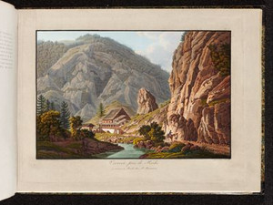
In 1797, five men founded the Roches glassworks in the municipality of Rebeuvelier. In addition to the usual prerequisites for this type of industrial operation - nearby forests that could cover the enormous demand for wood and a watercourse - the road passing by here probably also played a role. Even more than most of the other places depicted in this Voyage pittoresque picture, the Roches glassworks became famous as a pictorial motif and was depicted several times, including in French and Dutch publications, until its closure and relocation to Moutier in 1869. This view by Peter Birmann marks the beginning.

Ort auf moderner Karte
GEOMETRYCOLLECTION (POINT (7.390248 47.313034), LINESTRING (7.390248 47.313034, 7.390489 47.313667))
Camera Settings (3D)
{"landscape":{"image.scale":47,"viewpoint":{"bounds":[[7.373740344966706,47.30402531391809],[7.395024212146694,47.31238997104728]],"bearing":17.29966011489489,"pitch":85,"zoom":18.73561627570266,"center":{"lng":7.3903280496606385,"lat":47.31334701245524},"cam":{"center":{"lng":7.389114670515056,"lat":47.308564342205074},"zoom":15.384992813210953,"bearing":0},"cameraToCenterDistance":1107.646491440297,"cameraPosition":{"lngLat":{"lng":7.389799493115277,"lat":47.312196429693415},"altitude":508.0124548401579},"cameraTargetElevation":496.2890136721381},"camera.fov":60},"portrait":{"image.scale":35,"viewpoint":{"bounds":[[7.373740345036055,47.30402531395177],[7.395024212131517,47.31238997104728]],"bearing":17.29966011489489,"pitch":85,"zoom":18.73561627570266,"center":{"lng":7.390328049660297,"lat":47.313347012455154},"cameraToCenterDistance":1107.646491440297,"cameraPosition":{"lngLat":{"lng":7.389799493114907,"lat":47.3121964296933},"altitude":508.01245484015794},"cameraTargetElevation":496.2890136721381}},"square":{"image.scale":50,"viewpoint":{"bounds":[[7.36378954032179,47.296940329963945],[7.396656128334428,47.31219965474858]],"bearing":17.29966011489489,"pitch":85,"zoom":18.73561627570266,"center":{"lng":7.390328049659729,"lat":47.313347012454926},"cam":{"center":{"lng":7.528122480384951,"lat":47.31571280224793},"zoom":10.419087592775712,"bearing":0},"cameraToCenterDistance":1371.4121756658628,"cameraPosition":{"lngLat":{"lng":7.389673627073137,"lat":47.31192243583118},"altitude":510.8041772037977},"cameraTargetElevation":496.2890136721381}}}
Quellen

Emmanuelle Evéquoz, Ursule Babey et al, Rebeuvelier - La Verrerie, redécouverte d'un passé préindustriel, Porrentruy 2013, (Cahier d'archéologie jurassienne 35) pp. 11-26 [29.07.2024]

Bilder
nb-477222
Ort
GEOMETRYCOLLECTION (POINT (7.385888 47.311769), LINESTRING (7.385888 47.311769, 7.387015 47.317304))
Titel
Avenue de Roche
Text

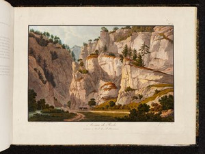
"The rocks (Jurassic limestone), often stand like sky-high, vertically juxtaposed and violently cracked slabs and contain many caves."


Ort auf moderner Karte
GEOMETRYCOLLECTION (POINT (7.391033 47.311976), LINESTRING (7.391033 47.311976, 7.391097 47.314173))
Camera Settings (3D)
{"landscape":{"image.scale":84,"viewpoint":{"bounds":[[6.946354804106022,47.073861777968375],[7.652924207047249,47.30976793355623]],"bearing":1.638449394779741,"pitch":80.5275196759414,"zoom":17.56026286300571,"center":{"lng":7.3910329999984015,"lat":47.31197600000007},"cam":{"center":{"lng":7.4512728796802605,"lat":47.2033937664294},"zoom":10.38311887084745,"bearing":0},"cameraToCenterDistance":1177.8124816183965,"cameraPosition":{"lngLat":{"lng":7.390912154189067,"lat":47.30911150463098},"altitude":533.25916143755},"cameraTargetElevation":480.09452547718706},"camera.fov":57},"portrait":{"image.scale":99,"viewpoint":{"bounds":[[6.946354815699323,47.073861784032744],[7.652924200335434,47.30976793355546]],"bearing":1.638449394779741,"pitch":80.5275196759414,"zoom":17.56026286300571,"center":{"lng":7.3910329999984015,"lat":47.31197599999902},"cameraToCenterDistance":1177.8124816183965,"cameraPosition":{"lngLat":{"lng":7.390912154189067,"lat":47.30911150462995},"altitude":533.2591614375511},"cameraTargetElevation":480.09452547718706}},"square":{"image.scale":89,"viewpoint":{"bounds":[[6.946354815736981,47.07386178413989],[7.65292420025645,47.30976793355606]],"bearing":1.638449394779741,"pitch":80.5275196759414,"zoom":17.56026286300571,"center":{"lng":7.391032999997492,"lat":47.31197599999993},"cam":{"center":{"lng":10.47920173833441,"lat":47.43147570957052},"zoom":5.9929499522613385,"bearing":0},"cameraToCenterDistance":1177.8124816183965,"cameraPosition":{"lngLat":{"lng":7.390912154188243,"lat":47.309111504630835},"altitude":533.2591614375501},"cameraTargetElevation":480.09452547718706}}}
Quellen

Heinrich Heidegger, Handbuch für Reisende in der Schweiz, 4th edition, Zurich 1818, p. 329

Bilder
nb-477223
Ort
GEOMETRYCOLLECTION (POINT (7.381516 47.304233), LINESTRING (7.381516 47.304233, 7.370187 47.293383))
Titel
Village de Roche
Text

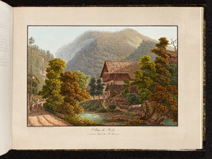
The village of Roches had around 250 inhabitants around 1800, slightly more than today. It became part of the canton of Bern in 1815, where it has remained to this day.


Ort auf moderner Karte
GEOMETRYCOLLECTION (POINT (7.385251 47.302603), LINESTRING (7.385251 47.302603, 7.38483 47.302261))
Camera Settings (3D)
{"landscape":{"camera.fov":60,"image.scale":40,"viewpoint":{"bounds":[[7.27746960672701,47.24688421223357],[7.406043319179048,47.303309204027386]],"bearing":-153.53550369195898,"pitch":76.48985560017324,"zoom":18.646312323641936,"center":{"lng":7.384968996048201,"lat":47.30224295318055},"cam":{"center":{"lng":7.37365951443951,"lat":47.27750923508415},"zoom":12.631939865001168,"bearing":0},"cameraToCenterDistance":1107.646491440297,"cameraPosition":{"lngLat":{"lng":7.385791493775429,"lat":47.30336337519199},"altitude":526.4734408465021},"cameraTargetElevation":493.0355468750014}},"portrait":{"image.scale":38,"viewpoint":{"bounds":[[7.277469606488523,47.24688421209203],[7.406043319212046,47.303309204027926]],"bearing":-153.53550369195898,"pitch":76.48985560017324,"zoom":18.646312323641936,"center":{"lng":7.384968996047974,"lat":47.30224295318121},"cameraToCenterDistance":1107.646491440297,"cameraPosition":{"lngLat":{"lng":7.38579149377523,"lat":47.30336337519262},"altitude":526.4734408465016},"cameraTargetElevation":493.0355468750014}},"square":{"viewpoint":{"bounds":[[7.277469606685941,47.246884212214695],[7.40604331917109,47.303309204027386]],"bearing":-153.53550369195898,"pitch":76.48985560017324,"zoom":18.646312323641936,"center":{"lng":7.384968996048656,"lat":47.302242953180496},"cam":{"center":{"lng":7.920338169111687,"lat":47.31870353143344},"zoom":8.451185484352193,"bearing":0},"cameraToCenterDistance":1107.646491440297,"cameraPosition":{"lngLat":{"lng":7.385791493775969,"lat":47.303363375191935},"altitude":526.4734408465021},"cameraTargetElevation":493.0355468750014},"image.scale":40}}
Quellen

Christine Gagnebin-Diacon, "Roches (BE)", in: Historisches Lexikon der Schweiz (HLS), version of 16.05.2012, translated from French [12.01.2024]

Bilder
nb-477224
Ort
GEOMETRYCOLLECTION (POINT (7.378079 47.294716), LINESTRING (7.378079 47.294716, 7.381085 47.289521))
Titel
La Charbonniere
Text

"The many forges and ironworks spread across the entire edge of the Jura consume a lot of coal. However, the area is so full of forests that there will be no shortage of the raw material for production for a long time. After leaving the village of Roche behind, it is a pleasure to stop near a pub that makes this type of work as interesting for the observer as it is romantic for the painter. The charcoal piles smoke in a spacious area of bizarrely stacked rocks under the shade of trees that protect the base and sides of the piles, next to the Birs, which is hemmed in by small dams. You can see how the workers pile up the wood they have brought from far away, cut it into equal-sized logs and shape it into an even cone, which a slow and gradual fire finally burns into coal and covers with earth or sometimes with damp moss. Once the fire is burning, they must watch over it day and night, and these disciples of Vulcan, shrouded in smoke like their master, take turns on their feet until the burning process is complete [...]."


Ort auf moderner Karte
GEOMETRYCOLLECTION (POINT (7.380311 47.292839), LINESTRING (7.380311 47.292839, 7.380881 47.292089))
Camera Settings (3D)
{"landscape":{"viewpoint":{"bounds":[[7.364366364803573,47.29372062705582],[7.386855446163935,47.30680150296186]],"bearing":148.75484212522497,"pitch":85,"zoom":18.60641436724738,"center":{"lng":7.380407899623265,"lat":47.29284164529915},"cam":{"center":{"lng":7.383010434998937,"lat":47.30081902635865},"zoom":14.740128839753597,"bearing":0},"cameraToCenterDistance":1153.6885394960755,"cameraPosition":{"lngLat":{"lng":7.379357647425621,"lat":47.29401574791504},"altitude":536.2528847522858},"cameraTargetElevation":522.8929414662409},"camera.fov":58},"portrait":{"viewpoint":{"bounds":[[7.364366364702931,47.293720627054114],[7.386855446225269,47.30680150306031]],"bearing":148.75484212522497,"pitch":85,"zoom":18.60641436724738,"center":{"lng":7.380407899623606,"lat":47.29284164529733},"cameraToCenterDistance":1153.6885394960755,"cameraPosition":{"lngLat":{"lng":7.379357647426048,"lat":47.29401574791319},"altitude":536.2528847522863},"cameraTargetElevation":522.8929414662409}},"square":{"viewpoint":{"bounds":[[7.36436636433362,47.293720627054284],[7.386855446407765,47.30680150337278]],"bearing":148.75484212522497,"pitch":85,"zoom":18.60641436724738,"center":{"lng":7.380407899622924,"lat":47.2928416452973},"cam":{"center":{"lng":7.4768117747042595,"lat":47.30788647637121},"zoom":10.966484509565301,"bearing":0},"cameraToCenterDistance":1153.6885394960755,"cameraPosition":{"lngLat":{"lng":7.379357647425309,"lat":47.294015747913164},"altitude":536.2528847522863},"cameraTargetElevation":522.8929414662409}}}
Quellen

Voyage pittoresque de Basle à Bienne par les Vallons de Mottiers-Grandval, Basel 1802, p. 22

Bilder
nb-477225
Ort
GEOMETRYCOLLECTION (POINT (7.377229 47.295573), LINESTRING (7.377229 47.295573, 7.380571 47.288454))
Titel
Le Pont de Penne
Text

"A well-maintained road from Basel to Biel leads through the Münsterthal, along the Birs, sometimes on the left bank, sometimes on the right. The course of this river, its many picturesque falls and bridges, as well as the formation of the rocks captivate the attention of every lover of nature." - "The walk along the road to Delémont, to the bridge of Pennes, which is very picturesque with its surroundings, the cave of St. Germanus has been partly sacrificed to the road, the trickling of small streams over mossy rocks deserves to be seen."


Ort auf moderner Karte
GEOMETRYCOLLECTION (POINT (7.380478 47.292411), LINESTRING (7.380478 47.292411, 7.381009 47.291596))
Camera Settings (3D)
{"landscape":{"viewpoint":{"bounds":[[7.3684005381993245,47.29317952299837],[7.385290660392172,47.3029130526339]],"bearing":148.08206336021019,"pitch":85,"zoom":18.899490059808734,"center":{"lng":7.380430698392729,"lat":47.292494629429854},"cam":{"center":{"lng":7.382351386766032,"lat":47.2984613924952},"zoom":15.166613461097272,"bearing":0},"cameraToCenterDistance":1107.646491440297,"cameraPosition":{"lngLat":{"lng":7.379591862133253,"lat":47.29340803348171},"altitude":542.8548986926412},"cameraTargetElevation":532.3861328120734},"camera.fov":60,"image.scale":40},"portrait":{"viewpoint":{"bounds":[[7.368400538383355,47.29317952300076],[7.3852906603549116,47.30291305257765]],"bearing":148.08206336021019,"pitch":85,"zoom":18.899490059808734,"center":{"lng":7.380430698391024,"lat":47.29249462943258},"cameraToCenterDistance":1107.646491440297,"cameraPosition":{"lngLat":{"lng":7.379591862131491,"lat":47.29340803348444},"altitude":542.8548986926407},"cameraTargetElevation":532.3861328120734},"image.scale":40},"square":{"viewpoint":{"bounds":[[7.368400538387391,47.29317952300016],[7.3852906603135295,47.30291305248517]],"bearing":148.08206336021019,"pitch":85,"zoom":18.899490059808734,"center":{"lng":7.380430698392729,"lat":47.29249462943176},"cam":{"center":{"lng":7.45285114801797,"lat":47.30377351289118},"zoom":11.379529543426441,"bearing":0},"cameraToCenterDistance":1107.646491440297,"cameraPosition":{"lngLat":{"lng":7.379591862133282,"lat":47.293408033483615},"altitude":542.8548986926409},"cameraTargetElevation":532.3861328120734},"image.scale":40}}
Quellen

Heinrich Heidegger, Handbuch für Reisende durch die Schweiz, 4th edition, Zurich 1818, pp. 329-330

Bilder
nb-477226
Ort
GEOMETRYCOLLECTION (POINT (7.380024 47.289303), POINT (7.380024 47.289303), LINESTRING (7.380024 47.289303, 7.380214 47.28629))
Titel
Echappé sur la Birse
Text

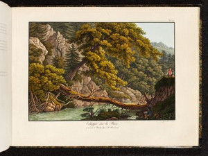
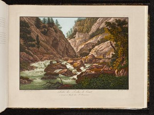
The at first glance inconspicuous event of a tree trunk toppled over the river leads Philippe-Sirice Bridel to a detailed reflection on the nature of this landscape: 
"[...] a decoration whose plan and execution can only be attributed to nature, which alone has borne all the costs: ... She has overturned a great tree by the hand of time, she has thrown it boldly over the Birs, she has fastened it to one bank and the other by thrusting its ends into its crevices, she has commanded the winds and the waves to strip it of its superfluous branches: and here is a new kind of bridge, which even has two separate arches [...]. The squirrel hops over it, ... the billy goat ventures over it without fear, ... the fisherman who haunts this lonely beach uses it like a causeway to steady his slippery steps as he walks half-naked from one fountain to another, ... the river, flowing peacefully below, takes pleasure in repeating, in a calm azure blanket, this work in which man has not interfered. The whole environment is perfectly similar to this natural bridge, and even the disorder that characterizes it is in harmony with it [...]."


Ort auf moderner Karte
GEOMETRYCOLLECTION (POINT (7.381514 47.28804), LINESTRING (7.381514 47.28804, 7.381524 47.287486))
Camera Settings (3D)
{"landscape":{"image.scale":38,"viewpoint":{"bounds":[[7.368438337205447,47.28890515231339],[7.397350786294027,47.29947501607646]],"bearing":172.57967089710996,"pitch":85,"zoom":18.348338970591463,"center":{"lng":7.381537109609894,"lat":47.287585225127174},"cam":{"center":{"lng":7.3890993198253625,"lat":47.29465793277163},"zoom":14.99418742185608,"bearing":0},"cameraToCenterDistance":1107.646491440297,"cameraPosition":{"lngLat":{"lng":7.381236873203335,"lat":47.289148922402035},"altitude":546.252254124625},"cameraTargetElevation":530.9114257814736}},"portrait":{"viewpoint":{"bounds":[[7.36843833723043,47.28890515230941],[7.397350786292179,47.29947501606327]],"bearing":172.57967089710996,"pitch":85,"zoom":18.348338970591463,"center":{"lng":7.381537109612282,"lat":47.28758522512325},"cameraToCenterDistance":1107.646491440297,"cameraPosition":{"lngLat":{"lng":7.381236873205751,"lat":47.289148922398056},"altitude":546.2522541246261},"cameraTargetElevation":530.9114257814736},"image.scale":39},"square":{"viewpoint":{"bounds":[[7.36843833711572,47.28890515230498],[7.397350786439915,47.299475016154275]],"bearing":172.57967089710996,"pitch":85,"zoom":18.348338970591463,"center":{"lng":7.38153710961285,"lat":47.28758522511882},"cam":{"center":{"lng":7.513000583736755,"lat":47.30399414513761},"zoom":10.604018453899,"bearing":0},"cameraToCenterDistance":1107.646491440297,"cameraPosition":{"lngLat":{"lng":7.381236873206319,"lat":47.28914892239368},"altitude":546.2522541246274},"cameraTargetElevation":530.9114257814736},"image.scale":39}}
Quellen

Voyage pittoresque de Basle à Bienne par les Vallons de Mottiers-Grandval, Basel 1802, p. 24

Bilder
nb-477227
Ort
GEOMETRYCOLLECTION (POINT (7.381179 47.286184), LINESTRING (7.381179 47.286184, 7.383003 47.287625))
Titel
La Cape aux Mousses
Text

Click on "Open image details" for more information.

Ort auf moderner Karte
GEOMETRYCOLLECTION (POINT (7.38185 47.285022), LINESTRING (7.38185 47.285022, 7.382479 47.28572))
Camera Settings (3D)
{"landscape":{"image.scale":32,"viewpoint":{"bounds":[[7.327961891888293,47.25764343510028],[7.415712338688365,47.28484624824213]],"bearing":0,"pitch":85,"zoom":16.75875620282626,"center":{"lng":7.381970286369324,"lat":47.288970674793774},"cam":{"center":{"lng":7.390668805808758,"lat":47.27266633002995},"zoom":13.392471771079911,"bearing":0},"cameraToCenterDistance":1107.646491440297,"cameraPosition":{"lngLat":{"lng":7.381970286369324,"lat":47.28422463191828},"altitude":593.6163610439149},"cameraTargetElevation":547.4474609371927}},"portrait":{"image.scale":32,"viewpoint":{"bounds":[[7.323252947310834,47.255461129831616],[7.418519182684122,47.284870764856464]],"bearing":0,"pitch":83.5,"zoom":17.439381462310827,"center":{"lng":7.381887137891113,"lat":47.28734779380153},"cameraToCenterDistance":1107.646491440297,"cameraPosition":{"lngLat":{"lng":7.381887137891113,"lat":47.2843945176501},"altitude":584.8617056677907},"cameraTargetElevation":547.4474609371927}},"square":{"image.scale":30,"viewpoint":{"bounds":[[7.32325294700604,47.255461129674416],[7.418519182887508,47.284870764857146]],"bearing":0,"pitch":83.5,"zoom":17.439381462310827,"center":{"lng":7.381887137891226,"lat":47.28734779380221},"cam":{"center":{"lng":7.799584126413492,"lat":47.30247920314949},"zoom":8.883744299224286,"bearing":0},"cameraToCenterDistance":1107.646491440297,"cameraPosition":{"lngLat":{"lng":7.381887137891255,"lat":47.28439451765078},"altitude":584.8617056677903},"cameraTargetElevation":547.4474609371927}}}
Bilder
nb-477228
Ort
GEOMETRYCOLLECTION (POINT (7.380386 47.286584), LINESTRING (7.380386 47.286584, 7.381158 47.283265))
Titel
Sortie des Roches de Moutier
Text

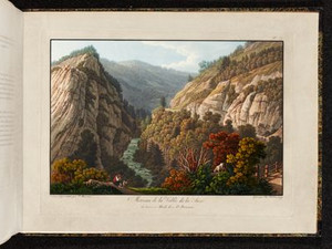
According to Johann Gottfried Ebel, it took around two hours to cross the gorges of Moutiers - but if you were traveling for the sake of traveling, the travel time could easily double:
"It took me more than four hours to walk through the gorge of Moûtiers, stopping at every rock and, as it were, at every step, constantly hemmed in between two huge limestone walls, on the edge of the roaring Birs and in the depths of a precipice where the path, uneven and tortured like the Birs itself, had been conquered with courage and diligence only on the debris of the mountains and in the bed of the torrent."


Ort auf moderner Karte
GEOMETRYCOLLECTION (POINT (7.381734 47.285416), LINESTRING (7.381734 47.285416, 7.38182 47.285052))
Camera Settings (3D)
{"landscape":{"viewpoint":{"bounds":[[7.372846140619572,47.286350018181395],[7.393192398268781,47.293558880854334]],"bearing":174.0727564559875,"pitch":85,"zoom":18.85966562724858,"center":{"lng":7.381781190633774,"lat":47.28541555441538},"cam":{"center":{"lng":7.387385679431503,"lat":47.2902836475063},"zoom":15.501114782822194,"bearing":0},"cameraToCenterDistance":1107.646491440297,"cameraPosition":{"lngLat":{"lng":7.381612765029075,"lat":47.28651600880963},"altitude":557.8314754131994},"cameraTargetElevation":547.0682617187515},"image.scale":31},"portrait":{"image.scale":32,"viewpoint":{"bounds":[[7.372846140565599,47.28635001817983],[7.393192398348276,47.293558880898416]],"bearing":174.0727564559875,"pitch":85,"zoom":18.85966562724858,"center":{"lng":7.38178119063457,"lat":47.28541555441373},"cameraToCenterDistance":1107.646491440297,"cameraPosition":{"lngLat":{"lng":7.3816127650298995,"lat":47.28651600880798},"altitude":557.8314754131998},"cameraTargetElevation":547.0682617187515}},"square":{"image.scale":32,"viewpoint":{"bounds":[[7.372846140618634,47.28635001818006],[7.393192398280377,47.29355888085627]],"bearing":174.0727564559875,"pitch":85,"zoom":18.85966562724858,"center":{"lng":7.381781190634001,"lat":47.28541555441396},"cam":{"center":{"lng":7.474577428927432,"lat":47.296854438598416},"zoom":11.1109458257318,"bearing":0},"cameraToCenterDistance":1107.646491440297,"cameraPosition":{"lngLat":{"lng":7.3816127650293595,"lat":47.286516008808206},"altitude":557.8314754131997},"cameraTargetElevation":547.0682617187515}}}
Quellen

Johann Gottfried Ebel, Anleitung, auf die nützlichste und genussvollste Art die Schweitz bereisen, vol. 3, Zurich 1810, p. 516; Désiré Raoul Rochette, Lettres sur la Suisse, Paris 1828, pp. 26-27

Bilder
nb-477229
Ort
GEOMETRYCOLLECTION (POINT (7.359277 47.272091), LINESTRING (7.359277 47.272091, 7.381932 47.284436))
Titel
Bourg de Moutier
Text

"At the exit of this narrow gorge, you suddenly find yourself in a wide and fertile valley in which lies the beautiful village of Moûtiers-Grand-Val. Among this collection of rustic dwellings, all uniform and crowded together, the bailiff's house alone stands out for its somewhat ambitious height [...]."
The monastery of Moutier-Grandval was founded on this site around 640. The village of Moutier was formed around it in the 12th century at the latest. In 1531, the monastery was moved to Delsberg as part of the Reformation. However, Moutier remained the capital of the so-called Probstei Moutier-Grandval, a bailiwick of the Prince-Bishopric of Basel, until 1797. It then passed to France and in 1815 to the canton of Bern. In 2026, Moutier is expected to become part of the canton of Jura following repeated referendums.


Ort auf moderner Karte
GEOMETRYCOLLECTION (POINT (7.36062 47.270641), LINESTRING (7.36062 47.270641, 7.361929 47.271309))
Camera Settings (3D)
{"landscape":{"viewpoint":{"bounds":[[7.284851204635061,47.22987109788863],[7.3608834029936645,47.285787571284885]],"bearing":53.10474974732142,"pitch":82.72166879773425,"zoom":17.76916525329568,"center":{"lng":7.362615466117859,"lat":47.27160399207207},"cam":{"center":{"lng":7.354472524013204,"lat":47.26022004803656},"zoom":12.645471421137279,"bearing":0},"cameraToCenterDistance":1107.646491440297,"cameraPosition":{"lngLat":{"lng":7.359849707742626,"lat":47.27019520072608},"altitude":574.1096063712199},"cameraTargetElevation":540.7843750000004},"image.scale":25},"portrait":{"image.scale":26,"viewpoint":{"bounds":[[7.286290638651906,47.230667802254146],[7.3607292686801316,47.2854120978528]],"bearing":53.10474974732142,"pitch":82.72166879773425,"zoom":17.799724253393176,"center":{"lng":7.3624250292778015,"lat":47.271525734478644},"cameraToCenterDistance":1107.646491440297,"cameraPosition":{"lngLat":{"lng":7.359717238775943,"lat":47.270146468510774},"altitude":574.1096244513759},"cameraTargetElevation":541.4828124999423}},"square":{"image.scale":26,"viewpoint":{"bounds":[[7.286290638935128,47.23066780238102],[7.360729268679535,47.285412097775975]],"bearing":53.10474974732142,"pitch":82.72166879773425,"zoom":17.799724253393176,"center":{"lng":7.3624250292774605,"lat":47.27152573447742},"cam":{"center":{"lng":7.65848378765719,"lat":47.28330165954023},"zoom":9.239657787385692,"bearing":0},"cameraToCenterDistance":1107.646491440297,"cameraPosition":{"lngLat":{"lng":7.359717238775573,"lat":47.27014646850955},"altitude":574.1096244513767},"cameraTargetElevation":541.4828124999423}}}
Quellen

Désiré Raoul Rochette, Lettres sur la Suisse, Paris 1828, pp. 27-28 [translated by DeepL/author]; François Wisard, "Moutier (municipality)", in: Historisches Lexikon der Schweiz (HLS), version of 21.06.2017, translated from French [15.01.2024]; https://www.admin.ch/gov/de/start/dokumentation/medienmitteilungen.msg-id-90106.html [15.01.2024]

Bilder
nb-477230
Ort
GEOMETRYCOLLECTION (POINT (7.341952 47.256515), LINESTRING (7.341952 47.256515, 7.3386 47.24909))
Titel
Second Pont dans les Roches de Court
Text

Before the 1836 correction, the road ran through the Court gorge on the left bank of the Birs.


Ort auf moderner Karte
GEOMETRYCOLLECTION (POINT (7.343994 47.255314), LINESTRING (7.343994 47.255314, 7.342621 47.251891))
Camera Settings (3D)
{"landscape":{"image.scale":107,"viewpoint":{"bounds":[[7.2707610751897676,47.2570834257769],[7.634674305744483,47.4066732084687]],"bearing":-158.30464370254788,"pitch":80.52706271892087,"zoom":17.561735318445468,"center":{"lng":7.343993999999498,"lat":47.255314000000766},"cam":{"center":{"lng":7.537387674998513,"lat":47.33830701646599},"zoom":11.223783662054528,"bearing":0},"cameraToCenterDistance":1107.646491440297,"cameraPosition":{"lngLat":{"lng":7.345461835857151,"lat":47.257818042722505},"altitude":683.0212124288681},"cameraTargetElevation":633.0188479047232}},"portrait":{"image.scale":96,"viewpoint":{"bounds":[[7.270761075189569,47.25708342577647],[7.634674305703612,47.40667320842317]],"bearing":-158.30464370254788,"pitch":80.52706271892087,"zoom":17.561735318445468,"center":{"lng":7.343993999999157,"lat":47.25531400000034},"cameraToCenterDistance":1107.646491440297,"cameraPosition":{"lngLat":{"lng":7.3454618358569235,"lat":47.25781804272211},"altitude":683.0212124288686},"cameraTargetElevation":633.0188479047232}},"square":{"image.scale":96,"viewpoint":{"bounds":[[7.2707610751878065,47.2570834257763],[7.634674305717965,47.40667320846134]],"bearing":-158.30464370254788,"pitch":80.52706271892087,"zoom":17.561735318445468,"center":{"lng":7.343993999997792,"lat":47.25531400000028},"cam":{"center":{"lng":9.090327227838515,"lat":47.45510840938107},"zoom":6.950186688063748,"bearing":0},"cameraToCenterDistance":1107.646491440297,"cameraPosition":{"lngLat":{"lng":7.345461835855559,"lat":47.25781804272205},"altitude":683.0212124288686},"cameraTargetElevation":633.0188479047232}}}
Bilder
nb-477231
Ort
GEOMETRYCOLLECTION (POINT (7.342337 47.251837), LINESTRING (7.342337 47.251837, 7.3392 47.260373))
Titel
Rocher de l'Inscription
Text

A traveler with a knapsack transcribes an inscription carved into the rock in the center of the picture. The inscription, written in Latin by the Strasbourg history professor Johann Daniel Schoepflin (1694-1771), reads: 
"Joseph Wilhelm Rinck von Baldenstein, Prince-Bishop of Basel, opened this road, which is lined with old rocks, obstructing mountain masses were blasted and the Birs was crossed by bridges; a work worthy of the Romans, in 1752."

It refers to the expansion of the road from Basel to Biel initiated by Prince-Bishop Jacob Sigismund von Reinach. This road was completely rebuilt in the Gorge de Court; previously it had led over the heights of Saulcy and Bellelay. This meant that the route was largely flat and could be used by horse-drawn vehicles without any problems, a feat that - in the eyes of contemporaries - had nothing to hide from Roman road construction. During roadworks in 1938, the inscription fell into the Birs and a copy was made.


Ort auf moderner Karte
GEOMETRYCOLLECTION (POINT (7.343069 47.251948), LINESTRING (7.343069 47.251948, 7.341868 47.256492))
Camera Settings (3D)
{"landscape":{"camera.fov":46,"image.scale":81,"viewpoint":{"bounds":[[7.137264796331749,47.24977646197979],[7.581239433266688,47.457285518492114]],"bearing":-7.480051123709472,"pitch":81.00000000000001,"zoom":17.910611890485182,"center":{"lng":7.3430689999987635,"lat":47.251948000000056},"cam":{"center":{"lng":7.47675353459158,"lat":47.362477117551066},"zoom":10.751028003400732,"bearing":0},"cameraToCenterDistance":1506.5675879442902,"cameraPosition":{"lngLat":{"lng":7.343621786252754,"lat":47.249090171469874},"altitude":716.8476812141957},"cameraTargetElevation":666.0862228718636}},"portrait":{"image.scale":75,"viewpoint":{"bounds":[[7.22231622666024,47.17132411514777],[7.440075434711048,47.25036354579535]],"bearing":-7.480051123709472,"pitch":81.00000000000001,"zoom":17.910611890485182,"center":{"lng":7.343069000000469,"lat":47.2519479999992},"cameraToCenterDistance":1107.646491440297,"cameraPosition":{"lngLat":{"lng":7.3434754150591175,"lat":47.249846905327956},"altitude":703.4066535536347},"cameraTargetElevation":666.0862228718636}},"square":{"image.scale":78,"viewpoint":{"bounds":[[7.137264788806789,47.24977646197925],[7.581239441879376,47.457285526086]],"bearing":-7.480051123709472,"pitch":81.00000000000001,"zoom":17.910611890485182,"center":{"lng":7.343068999998195,"lat":47.25194799999926},"cam":{"center":{"lng":9.357138054169752,"lat":47.50380880252223},"zoom":6.663303877097269,"bearing":0},"cameraToCenterDistance":1506.5675879442902,"cameraPosition":{"lngLat":{"lng":7.343621786252186,"lat":47.24909017146908},"altitude":716.8476812141965},"cameraTargetElevation":666.0862228718636}}}
Quellen

Voyage pittoresque de Basle à Bienne par les Vallons de Mottiers-Grandval 1802, p. 29; Inventar historischer Verkehrswege der Schweiz (IVS) BE 60 (PDF) [15.01.2024]

Bilder
nb-477232
Ort
GEOMETRYCOLLECTION (POINT (7.343671 47.248865), LINESTRING (7.343671 47.248865, 7.340839 47.258186))
Titel
Morceau des Roches de Court
Text

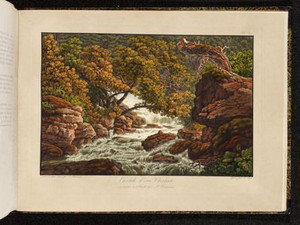
"Soon you enter a truly delicious place, because graceful forms follow threatening forms and the most cheerful images of the pastoral replace the austere images of the places described above: The mountains recede, leaving a small plain between their flanks, covered here with a flowering lawn, there with sparse bushes and, further back, shaded by various groups of trees that leave their flowing foliage to the play of the zephyrs. At the front, a magnificent fir tree guards this charming place like a sentinel [...] The Birs carries its peaceful waters in the meanders of these surroundings [...]."


Ort auf moderner Karte
GEOMETRYCOLLECTION (POINT (7.346055 47.246703), LINESTRING (7.346055 47.246703, 7.345572 47.248181))
Camera Settings (3D)
{"landscape":{"camera.fov":51,"image.scale":44,"viewpoint":{"bounds":[[7.3468033666142105,47.197696375148496],[7.40511186183889,47.24666347887975]],"bearing":-50.76582238070329,"pitch":83.5,"zoom":18.37035231042365,"center":{"lng":7.345323264609988,"lat":47.24728761385478},"cam":{"center":{"lng":7.40361628046719,"lat":47.224272715077205},"zoom":12.837902699185207,"bearing":0},"cameraToCenterDistance":1340.7396316168877,"cameraPosition":{"lngLat":{"lng":7.347464223711597,"lat":47.24610082551894},"altitude":708.3778950144118},"cameraTargetElevation":684.6062744140627}},"portrait":{"viewpoint":{"bounds":[[7.346894400012047,47.20036835543735],[7.4018152347814805,47.246489437985645]],"bearing":-50.76582238070329,"pitch":83.5,"zoom":18.45670491222319,"center":{"lng":7.345500290393829,"lat":47.247077313501364},"cameraToCenterDistance":1340.7396316168877,"cameraPosition":{"lngLat":{"lng":7.347516861999253,"lat":47.245959472622474},"altitude":708.3779565908686},"cameraTargetElevation":685.9873535166543}},"square":{"viewpoint":{"bounds":[[7.346894400015742,47.20036835774758],[7.40181523347502,47.24648943798428]],"bearing":-50.76582238070329,"pitch":83.5,"zoom":18.45670491222319,"center":{"lng":7.345500290398263,"lat":47.247077313499375},"cam":{"center":{"lng":7.621498567312074,"lat":47.24208013227275},"zoom":9.678355766620339,"bearing":0},"cameraToCenterDistance":1340.7396316168877,"cameraPosition":{"lngLat":{"lng":7.347516862003772,"lat":47.24595947262043},"altitude":708.3779565908695},"cameraTargetElevation":685.9873535166543}}}
Quellen

Voyage pittoresque de Basle à Bienne par les Vallons de Mottiers-Grandval, Basel 1802, p. 31

Bilder
nb-477233
Ort
GEOMETRYCOLLECTION (POINT (7.344355 47.247932), LINESTRING (7.344355 47.247932, 7.345556 47.243708))
Titel
Sortie des Roches de Court
Text

"This is the Birs, abandoning its role as a river to play that of a torrent; this is its bed, strewn with a thousand boulders, between which it breaks into various streams; it churns up roaring, foaming spray; it sweeps away the trunks, branches and roots of the trees it has overturned; It throws them indiscriminately like bridges between the various cliffs that emerge from its raging waters; it is a path carved like a ledge into the rocks in which it is embedded, and which the stranger must pass quickly for fear of being swallowed up along with the decayed ground that supports it. The firs cautiously leave this dangerous shore and retreat from the insult of the waves to higher banks, where the winds often do what the floods could not do by plunging them into the lower precipices. The mouth of this last gorge captivates the enthusiast with a wealth of detail of the most piquant kind."


Ort auf moderner Karte
GEOMETRYCOLLECTION (POINT (7.347798 47.245865), LINESTRING (7.347798 47.245865, 7.347842 47.245722))
Camera Settings (3D)
{"landscape":{"image.scale":71,"viewpoint":{"bounds":[[7.305874974873973,47.24726834080661],[7.351897171800289,47.28148895094989]],"bearing":139.01628294153522,"pitch":85,"zoom":17.837523275545536,"center":{"lng":7.347798000015359,"lat":47.24586499999242},"cam":{"center":{"lng":7.348230705869412,"lat":47.26584001153827},"zoom":13.353700963720447,"bearing":0},"cameraToCenterDistance":1340.7396316168877,"cameraPosition":{"lngLat":{"lng":7.3451683826849035,"lat":47.24791969124419},"altitude":692.0776599477388},"cameraTargetElevation":665.5984375000121}},"portrait":{"image.scale":70,"viewpoint":{"bounds":[[7.3058749752220535,47.24726834080627],[7.351897171729291,47.28148895064467]],"bearing":139.01628294153522,"pitch":85,"zoom":17.837523275545536,"center":{"lng":7.347798000015246,"lat":47.245864999992335},"cameraToCenterDistance":1340.7396316168877,"cameraPosition":{"lngLat":{"lng":7.34516838268479,"lat":47.24791969124411},"altitude":692.0776599477389},"cameraTargetElevation":665.5984375000121}},"square":{"image.scale":70,"viewpoint":{"bounds":[[7.305874974909528,47.24726834080377],[7.351897171817825,47.28148895092667]],"bearing":139.01628294153522,"pitch":85,"zoom":17.837523275545536,"center":{"lng":7.347798000019566,"lat":47.24586499998958},"cam":{"center":{"lng":7.535985959450954,"lat":47.279994816837444},"zoom":9.933379432637096,"bearing":0},"cameraToCenterDistance":1340.7396316168877,"cameraPosition":{"lngLat":{"lng":7.345168382689138,"lat":47.24791969124141},"altitude":692.0776599477402},"cameraTargetElevation":665.5984375000121}}}
Quellen

Voyage pittoresque de Basle à Bienne par les Vallons de Mottiers-Grandval, Basel 1802, p. 31

Bilder
nb-477234
Ort
GEOMETRYCOLLECTION (POINT (7.195143 47.215866), LINESTRING (7.195143 47.215866, 7.195612 47.212275))
Titel
Source de la Birse
Text

The Birs has its source in Tavannes. Formerly gushing out from under a moss-covered rock, its spring is now housed in a glass and concrete building. Shortly after its source, its water power was already being harnessed: "A few steps below Pierre-Pertuis is the source of the Birs, and this source is as enchanting as the Birs itself. It flows out of a moss-covered rock and, as soon as it has escaped from the urn in which it is located, it is already driving three mill wheels [...]."


Ort auf moderner Karte
GEOMETRYCOLLECTION (POINT (7.195326 47.215837), LINESTRING (7.195326 47.215837, 7.19538 47.215502))
Camera Settings (3D)
{"landscape":{"image.scale":47,"viewpoint":{"bounds":[[7.1003296195665655,47.1519690905279],[7.263608169829439,47.216458755657186]],"bearing":176.4805487043984,"pitch":78.52704926570581,"zoom":18.335664706881825,"center":{"lng":7.195493727923463,"lat":47.21507097776512},"cam":{"center":{"lng":7.218369295380228,"lat":47.18697245470537},"zoom":12.441679956378396,"bearing":0},"cameraToCenterDistance":1340.7396316168877,"cameraPosition":{"lngLat":{"lng":7.195322290562501,"lat":47.21696431178762},"altitude":805.9857046758341},"cameraTargetElevation":763.1750000001327}},"portrait":{"image.scale":42,"viewpoint":{"bounds":[[7.102125175173143,47.15344796183044],[7.262164217403921,47.21665712952813]],"bearing":176.4805487043984,"pitch":78.52704926570581,"zoom":18.36457610283805,"center":{"lng":7.195401191711426,"lat":47.21529689113174},"cameraToCenterDistance":1340.7396316168877,"cameraPosition":{"lngLat":{"lng":7.19523315573457,"lat":47.21715265342118},"altitude":805.9855589229422},"cameraTargetElevation":764.0244140624446}},"square":{"viewpoint":{"bounds":[[7.102125175130226,47.15344796177976],[7.262164217471906,47.21665712952813]],"bearing":176.4805487043984,"pitch":78.52704926570581,"zoom":18.36457610283805,"center":{"lng":7.195401191711312,"lat":47.2152968911318},"cam":{"center":{"lng":7.90232038683871,"lat":47.239417970947045},"zoom":8.135357290344086,"bearing":0},"cameraToCenterDistance":1340.7396316168877,"cameraPosition":{"lngLat":{"lng":7.1952331557344,"lat":47.21715265342124},"altitude":805.9855589229421},"cameraTargetElevation":764.0244140624446}}}
Quellen

Desiré Raoul-Rochette, Lettres sur la Suisse, Paris 1828, p. 34

Bilder
nb-477235
Ort
GEOMETRYCOLLECTION (POINT (7.194918 47.21411), LINESTRING (7.194918 47.21411, 7.191228 47.210029))
Titel
Pierre-Pertuis
Text

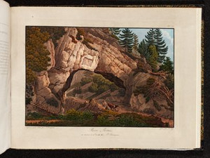
The Col de la Pierre-Pertuis connects Sonceboz in the Vallon de Saint-Imier with Tavannes in the Vallée de Tavannes. It is a vault dug into a large rock by the Romans, described by Philippe-Sirice Bridel as "an object to visit for the curious, a subject of essays for antiquarians, a valuable piece for painters who have drawn it from all directions".
This road was already used in Roman times and is said to date back to the second half of the 1st century. It was called "Petra Pertusa", which means "pierced stone", and connected two military roads: the one from Avenches via Solothurn to Augst and the one from Besançon via Mandeure to Kembs.


Ort auf moderner Karte
GEOMETRYCOLLECTION (POINT (7.194419 47.213171), LINESTRING (7.194419 47.213171, 7.19378 47.212767))
Camera Settings (3D)
{"landscape":{"viewpoint":{"bounds":[[7.193252541514852,47.214266775192414],[7.226008431170214,47.231628102326255]],"bearing":-149.60266858271683,"pitch":85,"zoom":18.520407642974888,"center":{"lng":7.194204926485554,"lat":47.21313063381922},"cam":{"center":{"lng":7.219437030439167,"lat":47.2236881541489},"zoom":14.333817573525675,"bearing":0},"cameraToCenterDistance":1340.7396316168877,"cameraPosition":{"lngLat":{"lng":7.1954686963554195,"lat":47.21459395372685},"altitude":846.0217300265685},"cameraTargetElevation":829.5171387293484}},"portrait":{"viewpoint":{"bounds":[[7.19325254149939,47.214266775192556],[7.226008431172261,47.23162810234058]],"bearing":-149.60266858271683,"pitch":85,"zoom":18.520407642974888,"center":{"lng":7.194204926486009,"lat":47.213130633819475},"cameraToCenterDistance":1340.7396316168877,"cameraPosition":{"lngLat":{"lng":7.195468696355874,"lat":47.214593953727075},"altitude":846.0217300265684},"cameraTargetElevation":829.5171387293484}},"square":{"viewpoint":{"bounds":[[7.193252541511612,47.214266775192414],[7.226008431119055,47.23162810230346]],"bearing":-149.60266858271683,"pitch":85,"zoom":18.520407642974888,"center":{"lng":7.194204926488396,"lat":47.213130633819276},"cam":{"center":{"lng":7.357031989548801,"lat":47.23407002080981},"zoom":10.423954955224923,"bearing":0},"cameraToCenterDistance":1340.7396316168877,"cameraPosition":{"lngLat":{"lng":7.195468696358205,"lat":47.214593953726876},"altitude":846.0217300265685},"cameraTargetElevation":829.5171387293484}}}
Quellen

Voyage pittoresque de Basle à Bienne par les Vallons de Mottiers-Grandval, Basel 1802, p. 30; Martin Bossert, "Pierre Pertuis", in: Historisches Lexikon der Schweiz (HLS), version of 28.09.2010 [29.07.2024]; Inventar historischer Verkehrswege der Schweiz (IVS) BE 39 (PDF) [15.01.2024]

Bilder
nb-477236
Ort
GEOMETRYCOLLECTION (POINT (7.25346 47.190098), LINESTRING (7.253242 47.190675, 7.257665 47.18689))
Titel
La Reuchenette
Text

The river in this view of La Reuchenette is no longer the Birs, but the Schüss/Suze, which flows through the Vallon de Saint-Imier and empties into Lake Biel. As in many other places in the Jura, there used to be a number of forges here. By the end of the 19th century, they were almost abandoned, as were the thermal baths that were located there.


Ort auf moderner Karte
GEOMETRYCOLLECTION (POINT (7.246661 47.189643), LINESTRING (7.246661 47.189643, 7.248123 47.188954))
Camera Settings (3D)
{"landscape":{"camera.fov":55,"viewpoint":{"bounds":[[7.21242040385502,47.18858923077943],[7.245577317596997,47.218226457078316]],"bearing":122.93768215472494,"pitch":85,"zoom":17.800953416327456,"center":{"lng":7.248043566942215,"lat":47.18908907795597},"cam":{"center":{"lng":7.2457332788710005,"lat":47.20467315678201},"zoom":13.562815898096076,"bearing":0},"cameraToCenterDistance":1228.4680701980606,"cameraPosition":{"lngLat":{"lng":7.244881161846308,"lat":47.19048138742667},"altitude":623.8748617788584},"cameraTargetElevation":598.9634521484386}},"portrait":{"image.scale":56,"viewpoint":{"bounds":[[7.212420404115392,47.18858923079702],[7.245577317596826,47.21822645699996]],"bearing":122.93768215472494,"pitch":85,"zoom":17.800953416327456,"center":{"lng":7.248043566941988,"lat":47.18908907795603},"cameraToCenterDistance":1228.4680701980606,"cameraPosition":{"lngLat":{"lng":7.244881161846109,"lat":47.19048138742676},"altitude":623.8748617788583},"cameraTargetElevation":598.9634521484386}},"square":{"image.scale":60,"viewpoint":{"bounds":[[7.212420404125709,47.18858923079631],[7.245577317598759,47.2182264569897]],"bearing":122.93768215472494,"pitch":85,"zoom":17.800953416327456,"center":{"lng":7.248043566944034,"lat":47.18908907795483},"cam":{"center":{"lng":7.3782049714907885,"lat":47.21467208218024},"zoom":10.406399571322098,"bearing":0},"cameraToCenterDistance":1228.4680701980606,"cameraPosition":{"lngLat":{"lng":7.244881161848184,"lat":47.190481387425564},"altitude":623.8748617788589},"cameraTargetElevation":598.9634521484386}}}
Quellen

Voyage pittoresque de Basle à Bienne par les Vallons de Mottiers-Grandval, Basel 1802, Vue de la Reuchenette

Bilder
nb-477237
Ort
GEOMETRYCOLLECTION (POINT (7.251058 47.177541), LINESTRING (7.251058 47.177541, 7.255434 47.178387))
Titel
Cascade d'eau Chesant
Text

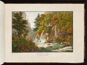
The Schüss/Suze river forms the Chesant waterfall in Rondchâtel (Bernese Jura), which travelers can see from the road. For this view, however, the illustrator Peter Birmann got as close as possible to the waterfall.


Ort auf moderner Karte
GEOMETRYCOLLECTION (POINT (7.246297 47.175153), LINESTRING (7.246297 47.175153, 7.247564 47.176118))
Camera Settings (3D)
{"landscape":{"image.scale":81,"viewpoint":{"bounds":[[7.244371671046679,47.149711376188975],[7.477898042307373,47.299549217868844]],"bearing":47.86556372820724,"pitch":78.52742577186402,"zoom":18.054384009787103,"center":{"lng":7.2465576231479645,"lat":47.175307996516466},"cam":{"center":{"lng":7.445773514473416,"lat":47.23106954643987},"zoom":11.224317538236335,"bearing":0},"cameraToCenterDistance":1228.4680701980606,"cameraPosition":{"lngLat":{"lng":7.2442515451502345,"lat":47.17388985376587},"altitude":641.0109906205295},"cameraTargetElevation":593.3067382816334}},"portrait":{"image.scale":72,"viewpoint":{"bounds":[[7.244371671047105,47.14971137638946],[7.4778980407415645,47.29954921702199]],"bearing":47.86556372820724,"pitch":78.52742577186402,"zoom":18.054384009787103,"center":{"lng":7.246557623148192,"lat":47.175307996515755},"cameraToCenterDistance":1228.4680701980606,"cameraPosition":{"lngLat":{"lng":7.244251545150519,"lat":47.17388985376519},"altitude":641.0109906205302},"cameraTargetElevation":593.3067382816334}},"square":{"image.scale":72,"viewpoint":{"bounds":[[7.2443716710480714,47.14971137647092],[7.477898039821582,47.29954921656224]],"bearing":47.86556372820724,"pitch":78.52742577186402,"zoom":18.054384009787103,"center":{"lng":7.246557623149215,"lat":47.17530799651567},"cam":{"center":{"lng":8.412003514915511,"lat":47.30392074764316},"zoom":7.590195729286861,"bearing":0},"cameraToCenterDistance":1228.4680701980606,"cameraPosition":{"lngLat":{"lng":7.244251545151485,"lat":47.173889853765104},"altitude":641.0109906205303},"cameraTargetElevation":593.3067382816334}}}
Quellen

Voyage pittoresque de Basle à Bienne par les Vallons de Mottiers-Grandval, Basel 1802, p. 35

Bilder
nb-477238
Ort
GEOMETRYCOLLECTION (POINT (7.256288 47.170268), LINESTRING (7.256288 47.170268, 7.245218 47.18217))
Titel
Morceau de la Vallée de la Suze
Text

In her memoirs, Elisabeth Vigée-Lebrun describes an incident on her journey from Basel to Biel, which could well have taken place in the Taubenloch gorge.
"Dear Countess, if you are afraid of precipices, I advise you not to take the path through the Prince-Bishopric of Basel; you may feel nothing but fear there; the precipices are as far as the eye can see, without parapets or fences; they are found on the right-hand side of the path; huge, precipitous cliffs line the left-hand side. I almost fell into these chasms. The horse leading my cart rode from right to left along the edge of the precipice. The path is narrow. Suddenly my horse reared up, blood shot out of its nostrils and splashed on the windows of my carriage, and the coachman tore himself away to stop the horse, which was still jumping up. I must admit that I was very frightened, but I hid my fear so as not to increase the fear of my dear companion Adelaide, and finally the heavens had mercy on us. Just as we were about to be swept into the abyss, a man (the only one we had met on that road) came up to us, opened the door and let us out; he immediately joined with the coachman to hold the horse and loosen the harness. The poor animal's collar was too tight, and the blood had rushed to his head. [...] We continued our journey almost always on foot, so as not to expose ourselves to new dangers, and arrived in Biel."


Ort auf moderner Karte
GEOMETRYCOLLECTION (POINT (7.253916 47.169939), LINESTRING (7.253916 47.169939, 7.253771 47.169983))
Camera Settings (3D)
{"landscape":{"image.scale":30,"viewpoint":{"bounds":[[7.25371820811003,47.12759608209504],[7.302094878915028,47.17988648014958]],"bearing":-67.5011783791702,"pitch":85,"zoom":16.889091174857306,"center":{"lng":7.248793244361877,"lat":47.171346834788466},"cam":{"center":{"lng":7.307404287399862,"lat":47.155976493746124},"zoom":12.745029672292006,"bearing":0},"cameraToCenterDistance":1130.312423387329,"cameraPosition":{"lngLat":{"lng":7.254819829124955,"lat":47.16964990596705},"altitude":602.2646810328131},"cameraTargetElevation":559.1250976556665},"camera.fov":59},"portrait":{"image.scale":27,"viewpoint":{"bounds":[[7.253718208110087,47.127596082064485],[7.302094878933758,47.17988648014901]],"bearing":-67.5011783791702,"pitch":85,"zoom":16.889091174857306,"center":{"lng":7.248793244361877,"lat":47.17134683478767},"cameraToCenterDistance":1130.312423387329,"cameraPosition":{"lngLat":{"lng":7.254819829124955,"lat":47.16964990596617},"altitude":602.2646810328138},"cameraTargetElevation":559.1250976556665}},"square":{"image.scale":35,"viewpoint":{"bounds":[[7.253718208111138,47.12759608223092],[7.302094878746743,47.17988648010939]],"bearing":-67.5011783791702,"pitch":85,"zoom":16.889091174857306,"center":{"lng":7.248793244363014,"lat":47.17134683478767},"cam":{"center":{"lng":7.495601561289135,"lat":47.17019404270175},"zoom":9.861397802086197,"bearing":0},"cameraToCenterDistance":1130.312423387329,"cameraPosition":{"lngLat":{"lng":7.254819829126063,"lat":47.16964990596614},"altitude":602.2646810328138},"cameraTargetElevation":559.1250976556665}}}
Quellen

Souvenirs de Madame Louise-Elisabeth Vigée-Lebrun, vol. 3, Paris 1837, pp. 232-234

Bilder
nb-477239
Ort
GEOMETRYCOLLECTION (POINT (7.269924 47.157564), LINESTRING (7.269924 47.157564, 7.24325 47.136804))
Titel
Environs du Lac de Bienne
Text

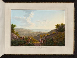
The actual destination of the Voyage pittoresque, Biel, can be seen from the exit of the Taubenloch gorge at the foot of the Bözingerberg. The old center of Biel is somewhat elevated, while the buildings have spread far into the plain over the last two centuries. Behind it, we can see Nidau with its castle.


Ort auf moderner Karte
GEOMETRYCOLLECTION (POINT (7.269119 47.158651), LINESTRING (7.269119 47.158651, 7.269001 47.158578))
Camera Settings (3D)
{"landscape":{"viewpoint":{"bounds":[[7.269540206922585,47.14804139904177],[7.342880585118365,47.198293627166066]],"bearing":-130.55686867761545,"pitch":81.02715849418156,"zoom":19.230633541966814,"center":{"lng":7.269031181931496,"lat":47.158664116217636},"cam":{"center":{"lng":7.334568747563338,"lat":47.175315366680366},"zoom":12.801860615691181,"bearing":0},"cameraToCenterDistance":1130.312423387329,"cameraPosition":{"lngLat":{"lng":7.270000715785784,"lat":47.1592283022795},"altitude":564.6286735984505},"cameraTargetElevation":549.3937652585112},"image.scale":34},"portrait":{"image.scale":31,"viewpoint":{"bounds":[[7.269581175718599,47.14778037678923],[7.344669974198382,47.19923028065739]],"bearing":-130.55686867761545,"pitch":81.02715849418156,"zoom":19.19664356023441,"center":{"lng":7.269060015678406,"lat":47.15865636496957},"cameraToCenterDistance":1130.312423387329,"cameraPosition":{"lngLat":{"lng":7.270052663016855,"lat":47.15923400112024},"altitude":564.6286740476648},"cameraTargetElevation":549.0305664057166}},"square":{"viewpoint":{"bounds":[[7.269581175718088,47.14778037679855],[7.344669974207534,47.19923028069482]],"bearing":-130.55686867761545,"pitch":81.02715849418156,"zoom":19.19664356023441,"center":{"lng":7.269060015677837,"lat":47.158656364969346},"cam":{"center":{"lng":7.6450251681653185,"lat":47.199027375172136},"zoom":9.227111579017805,"bearing":0},"cameraToCenterDistance":1130.312423387329,"cameraPosition":{"lngLat":{"lng":7.270052663016344,"lat":47.15923400112001},"altitude":564.628674047665},"cameraTargetElevation":549.0305664057166},"image.scale":35}}

Michel Grandjean, "Bridel, Philippe-Sirice", in: Historisches Lexikon der Schweiz (HLS), version of 12.01.2011, translated from the French [18.12.2023]; Voyage pittoresque de Basle à Bienne par les Vallons de Mottiers-Grandval, Basel 1802, p. 1; François Noirjean; Jean-Paul Prongué; Jean-Claude Rebetez; Philippe Froidevaux; André Bandelier, "Basel (Prince-Bishopric)", in: Historisches Lexikon der Schweiz (HLS), version of 12.08.2019, translated from French [18.12.2023]; Inventar historischer Verkehrswege der Schweiz (IVS) BE 61 (PDF) [18.12.2023]; https://ub-itb.ub.unibas.ch/de/detail/itbdrucker_116043431 [18.12.2023]; J. Christian Haldenwang in: SIKART Lexikon zur Kunst in der Schweiz [22.12.2023]; Yvonne Boerlin-Brodbeck, "Peter Birmann". In: SIKART Lexikon zur Kunst in der Schweiz, 2015 (first published in 1998); Paola von Wyss-Giacosa, "Franz Hegi". In: SIKART Lexikon zur Kunst in der Schweiz, 2017 (first published in 1998)

Download entire document as PDF

Bitte berühren!